


![]()
Вы здесь
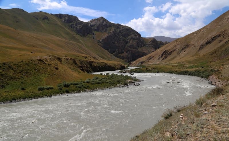
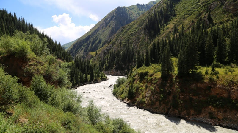
Naryn river.
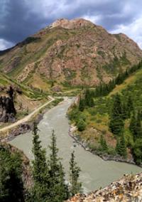
Sights of Naryn River.
“The Naryn River flows south, southwest to the tip of low mountains running along the left bank, its valley is swampy and flat: after passing 8 versts, the road crosses the river, heads south, the terrain rises, hilly, consists of deep pits filled with bitter water, the ground is hard and brackish, then the road goes westward along a dry bed of a stream flowing from the above mountains. The left bank of the Naryn overlooks the valley of the Karasai River.
Valikhanov Shokan. Collected works, volume 3. Almaty, 1985.
"This was the Naryn River, the headwaters of the ancient Jaxartes, on whose lower reaches (the Syr Darya) Russia already stood firmly. We wandered for another two hours between the Naryn's sources, but I didn't dare descend its valley: our horses were exhausted and wounded; with me, besides Kosharov, were only three Cossacks and two Karakirghiz."
P. P. Semenov-Tyan-Shansky. "Journey to Tien-Shan." 1857.
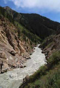
Rafting on Naryn River in Kyrgyzstan.
Naryn River (Alabugatuz; according to available information, "Alabugatuz" is not a separate tributary, but rather refers to parts or features of Naryn River) flows through Issyk-Kul, Naryn, Talas, and Jalal-Abad regions of Kyrgyz Republic and Namangan region of Republic of Uzbekistan.
The river flows through intermountain valleys and, in places, through narrow mountain gorges (the width of the river in these areas is 30-40 meters, and 45 meters near the city of Naryn). Below the confluence of the Maly Naryn River, the river flows in a wide valley (the Naryn Basin).
The river is 807 kilometers long, with a drainage basin area of 59,100 sq. km. The average discharge is 429 cubic meters per second. The Naryn basin extends latitudinally. The basin is bounded by the Terskey, Kyrgyz, and Talas Ala-Too ranges to the north, and by the Atbashi and Fergana ranges to the south.
The discharge at the confluence of the Greater and Lesser Naryns is 90 cubic meters per second. The average annual discharge at the city of Naryn is 88.4, while in the Fergana Valley it is 432, with the highest being 963 cubic meters per second.
The average annual water discharge at Uch-Korgon is 365 (the annual river discharge is 11.5), with a maximum discharge of 1908 and a minimum of 21.2 cubic meters per second. The average water discharge at the river mouth is 480, with a maximum discharge of 2820 cubic meters per second.
Suspended sediment load is 760 kg/s. The Naryn River's waters are used for irrigation. The Great Fergana Canal begins in the Naryn. It freezes from the second ten days of January (ice cover thickness 80-120 cm) until the end of March - early April, ice drift lasts for several days.
The average long-term discharge of suspended sediment near the city of Uch-Korgon is 500 kg/s (15.8 million tons per year). The water is used for irrigation. The Northern Fergana Canal begins from the Naryn River. After the confluence, the Naryn Valley's character frequently changes: wide, flat sections of the river give way to narrow canyons and gorges, filled with rapids and very turbulent currents.
In its upper reaches, the Naryn is a glacial-snow-fed river, with high summer runoff characteristic of this type. Downstream, due to the lowering of the catchment area and changing feeding conditions, the annual flow distribution gradually changes.
Flood season lasts from April to August. Maximum flow occurs in June and July. In its upper reaches, the river freezes. The river's water salinity ranges from 200 to 500 mg/l, increasing toward its mouth, especially during low water. Receiving numerous tributaries, the main ones being the Atbashi and Alabuga on the left, and the Kekjerty and Kökömeren on the right, the Naryn cuts through the Fergana Range.
Entering the Fergana Valley, the Naryn loses its mountain river character and, flowing along its alluvial fan, breaks into branches, forming a pebble floodplain up to 3.5 kilometers wide. Within the Fergana Valley, the Naryn merges with the Karadarya to form the Syr Darya River.
The river is formed entirely within Kyrgyzstan by melting glaciers and snow, with a perennial flow of 23.7 billion cubic meters. There are 750 glaciers in the Naryn basin, covering a combined area of over 1,000 square kilometers. Kyrgyzstan ranks fifth in the world in terms of hydroelectric resources.
The river has significant energy resources. The Toktogul, Tash-Kumyr, Uchkurgan, Kurpsai, and Shamaldysai hydroelectric power plants are located on it. The Kambaratinskaya-2 hydroelectric power plant is under construction, as well as the Upper Naryn hydroelectric power station cascade with associated reservoirs.
The cities of Naryn, Tash-Kemur, and Uch-Korgon (Uzbekistan) are located on the river's banks. The Toktogul Reservoir is located on the river. The Naryn River is formed by the confluence of the Karasai, Taragai, Ekurgen, and Dzhaman-Echki rivers, which originate in the Inner Tien-Shan in the Terskey Ala-Too, Jetim, Jetim-Bel, and Borkoldoy ranges, and partly in the Ak-Shyirak range of the Central Tien-Shan.
The main components of the Naryn River are the Kum-Tor, which flows from the western glaciers of the Ak-Shiyrak Range – the Petrov, Akbel, and Lysyi Glaciers. These glaciers descend to an altitude of 3,730 meters above sea level (the elevation of Lake Petrov) and form powerful ice flows.
The Western Petrov Glacier is 10 kilometers long, while the Eastern Petrov Glacier extends for 12.5 kilometers. The Naryn River basin contains 2,074 glaciers, covering a total area of 1,357.8 square kilometers. Merging with the Ara-Bel-Suu River, it forms the Taragai River.
The confluence of the Taragai and Dzhaman-Echki Rivers in the eastern Jetim Range, the western spurs of the Ak-Shiyrak Range, and the northern slopes of the eastern Chakyr-Korum Range form the Naryn River.
Geographic coordinates of formation of Naryn River are: N41°36'24 E77°43'16
From the confluence of the Bolgart and Karagoman rivers in the southeastern part of the Kapkatas Range and northeast of the beginning of the Jetim Range, the Maly Naryn River forms.
Geographic coordinates of formation of Malyi Naryn River are: N41°42'32 E76°44'51
In the southwestern part of the beginning of the Jetim Range and between the northern slopes of the western part of the Naryn-Too Range, the Maly Naryn forms and flows into the Bolshoi Naryn River.
Geographic coordinates of confluence of Malyi Naryn River and Naryn River are: N41°29'44 E76°25'20
Vast syrts are located in upper reaches of the Naryn River.
The syrts of the upper reaches of the Naryn River are wide buried valleys, partially filled with moraine and fluvioglacial deposits. Numerous glacial boulders cover their surface, and small lakes of moraine origin are common. Numerous streams flow through the valleys, creating, due to permafrost, swampy soil in the lower reaches.
In general, the szyrts of the upper Naryn River are wide, high-mountain valleys (3,600-3,700 m. a. s. l.), with a gently rolling topography, covered with lush grassy vegetation, and completely devoid of forest. The Naryn State Nature Reserve, covering 91,023.5 hectares, is located in the upper reaches of the river, where the Tien Shan maral population is protected and restored.
Geographical coordinates of Naryn River: N41°29'44 E77°01'37
Sources of Naryn River.
Main channel of Naryn river is formed from rivers: Taragai and Kumtor.
Taragay basin consists of following rivers: Kashka-Su, Arabel-Su, Ittysh, Kichi-Maytor, Maitor, Koturtor, Jetimbel, Choloktor, Sook.
Taragai river.
The Taragay River originates from the southern and southeastern slopes of the Terskey Ala-Too ridge. The river gets the name Taragay at an altitude of 3425 m. a. s. l. after the confluence of the Kashka-Su and Maytor rivers. The length of the river is 40 kilometers from the beginning of the confluence of the Kashka-Su and Maytor to the confluence of the right tributary of the Jamanechka.
From the beginning of its sources, the river receives 9 right tributaries, left - 4 tributaries, one of them is the largest - Kumtor.
The speed of the river flow is from 2 to 2.5 meters per second. The height difference on the river for 40 kilometers is 255 meters.
Geographical coordinates of Taragay river: N41°41'45 E77°50'44
Kashka-Su river.
The Kashka-Su River originates on the southern slope of the Terskey Ala-Too ridge at an altitude of 3881 m. a. s. l. from a cascade of lakes. The lakes are located south of the Kashka-Su pass, which is located in the main ridge of the Terskey Ala-Too ridge at an altitude of 3891 m. a. s. l. In the upper reaches, the river flows through a cascade of lakes.
The length of the river Kashka-Su is 30 kilometers. At 8 km after the sources, the river on the left receives a small tributary, which starts from two low-water lakes. At 16 km, the river on the left receives a tributary that flows from a large lake located at an altitude of 3782 m. a. s. l.
At the 20th kilometer, Kashka-Su receives a tributary on the left, which starts from a lake located at an altitude of 3627 meters above sea level. At 21 kilometers, the river crosses a road bridge, the road through which leads to the Kumtor mine. The long tributary Arabel-Su flows into the left for 24 kilometers.
Geographical coordinates of Kashka-Su River: N41°51'58 E78°04'54
Arabel-Su river.
The Arabel-Su River, 41 kilometers long, originates at an altitude of 3,779 meters above sea level from a group of lakes called Dzhashyl-Kel, which are located in the Arabel valley. In turn, the Arabel valley is located between the southern slopes of the Terskey Ala-Too ridge and the northern slopes of the Sook and Jetim-Bel ridges on syrt formations.
The Arabel-Su river basin consists of three main tributaries - Koturtor, Ittysh and Kichi-Maytor. The sources of the river start from the south-east side of the Barskoon pass located at an altitude of 3754 m. a. s. l. Just below the pass is Lake Barskoon at an altitude of 3750 m. a. s. l.
The river passes Lake Barskoon and after 1.8 kilometers flows into Lake Dzhashyl-Kel West, located at an altitude of 3779.1 m. a. s. l. Just 200 meters to the south is the Central Lake Dzhashyl-Kel, located at an altitude of 3779.1 meters above sea level. After 5.5 kilometers, the river flows into the Jashyl-Kel South Lake, located at an altitude of 3752 m. a. s. l.
The river bends around the Jetym-Bel ridge from the north, turns south and flows between the western slopes of the Akshiyrak ridge and the southeastern slopes of the Jetym-Bel ridge until it flows into the Taragai River. At the 28th kilometer in Arabel-Su on the left, the Katurtor River flows into the river at an altitude of 3647 m. a. s. l.
At 35 km after the sources, the Ittysh River flows to the left and a little higher, the Kichi-Maitor River flows to the right. Throughout its length, Kashka-Su receives 8 tributaries on the left, 15 tributaries on the right. The speed of the river flow is 1.1 - 1.2 meters per second.
Geographic coordinates of Arabel-Su River: N41°52'51 E77°53'20
Ittysh river.
The Ittysh River, 17 kilometers long, originates from the southern slope of the Ittysh pass, located at an altitude of 3880.2 m. a. s. l., which in turn is located in the main ridge of the Terskey Ala-Too ridge. 4 kilometers after the sources, the river receives a tributary on the left, which originates from the glaciers of the southern slope of the Terskey Ala-Too ridge.
At 7 km after the sources, a tributary flows from the left, originating from the watershed spur between the Kumtor and Arabel-Su rivers. At 14.5 km, the river receives a tributary on the left, which flows from a small lake located at an altitude of 3645 meters above sea level.
At the 17th kilometer of the Ittysh River, it flows from the left into the Arabel-Su River.
Geographic coordinates of Ittysh River: N41°57'13 E78°01'46
River Koturtor.
The Koturtor River is the left tributary of Arabel-Su, 8.5 kilometers long, originates from the Koturtor glacier, 5.3 kilometers long, which is located on the southern slope of the Terskey Ala-Too ridge. The beginning of the glacier is located in the main ridge of the ridge at an altitude of 4368 m. a. s. l., the tongue of the glacier lies at an altitude of 3882 m. a. s. l.
The mouth of the Koturtor River is located at an altitude of 3647 m. a. s. l.. The coturtor has 4 small tributaries on the right.
Geographical coordinates of river Koturtor: N41°55'24 E77°57'48
River Kichi-Maytor.
The Kichi-Maitor River, 8 kilometers long, is the right tributary of the Arabel Su River. The sources of the river are located on the northeastern slope of the Sook Range. The main channel of the river is formed from three tributaries: northern, central and southern at an altitude of 3894 m. a. s. l.
The southern tributary flows from the moraine lake Kichi-Maytor located at an altitude of 4081 meters above sea level. The length of the lake is 288 meters, the largest width in the central part reaches 190 meters. The mouth of the Kichi-Maytor River is located at an altitude of 3625 m. a. s. l.
Geographical coordinates of Kichi-Maytor River: N41°52'15 E78°00'33
Maitor river.
The Maitor River, 14.7 kilometers long, is the right tributary of the Taragay River. The sources of the river are located on the eastern slope of the Sook Range. The main channel of the river is formed from two small tributaries: northern and southern.
The southern tributary flows from the northern branch of the Maitor Yuzhny glacier. The length of the main glacier, which mostly lies on the southern slopes of the ridge, is 3.5 kilometers. The area of the glacier reaches 4.77 square kilometers, the perimeter of the glacier is 10.6 kilometers.
The length of the side branch of the glacier, from where the southern source of the Maytor River originates, is 1.9 kilometers, its area is 1.07 square kilometers, and its perimeter is 4.78 kilometers. There is a small moraine lake 600 meters below the glacier.
The upper part of the glacier is located at an altitude of 4573.2 m. a. s. l., the tongue of the glacier is located at an altitude of 3999 meters above sea level.The main channel of the river flows out of the large Maitor Zapadny glacier, 2.9 kilometers long.
The area of the glacier is 5.57 square kilometers, the perimeter is 10.06 kilometers. The upper part of the glacier is located at an altitude of 4573.2 m. a. s. l.l, the tongue of the glacier is located at an altitude of 3965 m. a. s. l. The mouth of the Maitor River is located at an altitude of 3458 m. a. s. l.
Geographical coordinates of Maytor River: N41°50'39 E78°03'10
Jetimbel river.
The Jetimbel River, 6.9 kilometers long, is the right tributary of the Taragay River. The main sources of the Jetimbel River are located on the southern slope of the Jetimbel pass, 3993.8 m. a. s. l. 180 meters below the pass there is a moraine lake with a length from south to north of 280 meters and a width of 125 meters.
The river is located on the southern exposition of the area - there are no glaciers in the sources of the river. The mouth of the Jetimbel River is located at an altitude of 3374 m. a. s. l.
Geographic coordinates of Jetimbel River: N41°47'04 E77°56'16
Choloktor river.
The Choloktor River, 14 kilometers long, is the left tributary of the Taragay River, located on the southern slope of the Akshiyrak ridge. The main channel of the river is formed at an altitude of 3478 m. a. s. l. There are no glaciers at the head of the river.
To the west of the river is a swampy plateau with numerous small lakes. The mouth of the river is located at an altitude of 3318m. a. s. l.
Geographic coordinates of Choloktor River: N41°41'30 E77°56'22
Sook river.
The Sook River, 15.7 kilometers long, is the right tributary of the Taragay River, located on the southern slope of the Sook Range. The main channel of the river is formed at an altitude of 3563 m. a. s. l. from three tributaries. The westernmost of them flows down from the southern slope of the Sook Pass, 4021 m. a. s. l.
There are no glaciers at the head of the river. The upper part of the sources is located at an altitude of 4573 m. a. s. l.. The mouth of the river is located at an altitude of 3307 m. a. s. l. Along the river, there is an automobile road connecting the syrts of the Inner Tien-Shan with the Issyk-Kul valley, and a high-voltage power line.
On the road A 364 you can get to the frontier outpost Karasai, the Uchkoshkon deposit and through the Ashu-Suu pass you can get to the Uzengegush river valley.
Geographic coordinates of Sook River: N41°44'34 E77°47'34
Kyzylchesme River.
The Kyzylcheshme River, 26 kilometers long, is the left tributary of the Taragai River, located on the southern slope of the Akshiyrak ridge. The upper part of the sources is located at an altitude of 4281 m. a. s. l. The mouth of the river is located at an altitude of 3299 m. a. s. l.
Geographical coordinates of Kyzylchesme River: N41°39'16 E77°56'19
Jamanechki river.
The Jamanechki River, 28 kilometers long, is the right and last tributary of the Taragay River after which it receives the name Naryn. The sources of the river are located between the northern slopes of the Jetim ridge and the southern slopes of the Jetim-Bel ridge.
On the left side, the river has 8 tributaries of the northern exposure Jetim-Bel. On the right side, the river receives 7 tributaries, one of which - Shorgosu - is a large southern exposition of Jetim. The northern main tributary originates from the Jamanechki glacier, 1.8 kilometers long, located in the side spur of a closed, deep circus.
The area of the glacier is 1.5 square kilometers, the perimeter is 4.94 kilometers. The upper part of the glacier is located at an altitude of 4425 m. a. s. l., the tongue of the glacier is at an altitude of 4055 m. a. s. l. On the western side in the spur there is a breakthrough through which water enters the upper reaches of the northern source.
The southern source of the river originates from the northern slope of the Jamanechki pass, 3863.5 m. a. s. l. The second right tributary originates from the Jamanechki South glacier, 2.8 kilometers long, consisting of two branches, located on the southern slope of the Jetim ridge. he area of the glacier is 3.63 square kilometers, the perimeter is 12.31 kilometers.
The upper part of the glacier is located at an altitude of 4469 meters above sea level, the tongue of the glacier is at an altitude of 3831 m. a. s. l. 3.7 kilometers to the mouth, on the right, the Dzhalgyzbulak tributary, 4.3 kilometers long, adjoins the Jamanechki, which also forms an extended ravine.
The mouth of Jlgyzbulak is located at an altitude of 3297 m. a. s. l. 2.4 kilometers to the mouth, on the right, the Koturchap tributary, 3.4 kilometers long, adjoins Jamanechki, which forms an extended ravine. The mouth of the river is located at an altitude of 3231 m. a. s. l.
Geographic coordinates of Jamanechka River: N41°38'45 E77°42'28
Shorgosu river.
Shorgosu River, 12.2 kilometers long, is the right tributary of the Jamanechka River. The river originates from the Shorgosu glacier, 1 km long, located in a side gorge on the northern slope of the Jetim ridge. The area of the glacier is 0.91 square kilometers, the perimeter is 4.9 kilometers.
The upper part of the glacier is at an altitude of 4384 m. a. s. l.l, the tongue of the glacier is at an altitude of 3957 m. a. s. l.
Geographical coordinates of Shorgosu River: N41°39'18 E77°39'09
Ekurgen river.
The Ekurgen River, 19.7 kilometers long, is the right tributary of the Taragay River, located on the southern slope of the Sook Range. The river mostly flows along the northern side of the Taragay valley. The source of the river is located on the southern slope of the Sarytor pass located at an altitude of 4050 m. a. s. l. in the main ridge of the Sook ridge.
For 4 kilometers from the pass to the confluence with Lake Ekurgen-Kel, located at an altitude of 3628.5 m. a. s. l., the river is called Sarytor. The remaining distance to the mouth of the river flows under the name of Ekurgen. 3.5 kilometers after Lake Ekurgen-Kel, on the left, the tributary Sarytor Zapadny flows into Ekurgen, 11.4 kilometers long.
Before the formation of the main channel, the river has 7 tributaries. The sources of the tributary originate from the Sarytor North and Sarytor West glaciers located on the southern slope of the Jetim-Bel ridge. The Sarytor Severny glacier is 1.5 kilometers long.
The area of the glacier is 0.73 square kilometers, the perimeter is 4.09 kilometers. The upper part of the glacier is at an altitude of 4341 m. a. s. l., the tongue of the glacier is at an altitude of 4193 m. a. s. l. Glacier Sarytor West with a length of 2.28 kilometers.
The area of the glacier is 1.78 square kilometers, the perimeter is 5.91 kilometers. The upper part of the glacier is located at an altitude of 4498 m. a. s. l., the tongue of the glacier is at an altitude of 4040 m. a. s. l. The mouth of the Ekurgen River is located at an altitude of 3249 m. a. s. l.
Geographic coordinates of Ekurgen River: N41°39'51 E77°43'57
Kumtor river.
Kumtor River basin consists of the main full-flowing rivers: left tributaries - Akbel, Bordu, Bordu South, Bordu North, Sarytor South, Sarytor North, right tributaries - the Arabel River. The sources of the Kumtor River, 32.5 kilometers long, are located on the western slope of the ridge Akshiyrak.
The river receives its main source from Lake Petrov, located at an altitude of 3730 m. a. s. l. The main channel of the river is formed at an altitude of 3625 m. a. s. l., almost 9 kilometers west of Petrov Lake, at the confluence of the Arabel River on the right.
The lake is filled from two glaciers: Western Petrov with a length of 11 kilometers and Eastern Petrov with a length of 13.6 kilometers. The top point of the Western Petrov glacier is located in the main ridge of the Akshiyrak ridge at an altitude of 4916 m. a. s. l.
The top point of the Vostochny Petrov glacier is located in the main ridge of the Akshiyrak ridge at an altitude of 5100 m. a. s. l. At 4 km after the sources, the river on the left receives a tributary Lysy, which flows from the glacier of the same name.
At 9 km after the sources, the river flows through the economic part of the Kumtor mine. At the 13th kilometer, the Sarytor tributary flows into the river on the left, which originates from two glaciers: Western Sarytor with a length of 3.9 kilometers and Sarytor East with a length of 3.6 kilometers.
At 18 km after the sources, Kumtor receives the Bordu North tributary from the right, at 24 km the river receives the Bordu South tributary from the left, and here the Akbel tributary adjoins. The mouth of the river is located at an altitude of 3346.3 m. a. s. l.
Geographic coordinates of Kumtor River: N41°47'36 E78°02'36
Arabel river.
The Arabel River, 20 kilometers long, originates from the southern slopes of the Dzhukuchak pass, 4042 m. a. s. l. The Dzhukuchak pass is located in the central ridge of the Terskey Ala-Too ridge. At 6.5 kilometers after the source, the river flows into Lake Dzhukuchak, located at an altitude of 3766.3 m. a. s. l.
The mouth of the river is located at an altitude of 3618 m. a. s. l.
Geographic coordinates of Arabel river: N41°56'35 E78°08'35
River Sarytor North.
The Sarytor Severny River, 6.7 kilometers long, is the left tributary of the Kumtor River. The sources of the Sarytor Severny River originate from the Sarytor Vostochny glacier, 3.6 kilometers long, located on the northeastern slope of the Akshiyrak ridge.
The area of the glacier is 3.55 square kilometers, the perimeter of the glacier reaches 10 kilometers. The upper part of the glacier is closed by the top of the SNK of Kyrgyzstan with a height of 4946.9 m. a. s. l. The tongue of the glacier is located at an altitude of 4022 m. a. s. l.
It should be noted that the glacier is located on the territory of the Kumtor gold deposit. The lower part of the glacier has been damaged by mining, the riverbed has been shifted more than 500 meters to the southwest.
Geographical coordinates of river Sarytor Severny: N41°52'13 E78°09'06
River Sarytor South.
The Sarytor South River, 5.1 kilometers long, is the left tributary of the Kumtor River. The sources of Sarytor South, originate from the Sarytor West glacier, 3.9 kilometers long, located on the northwestern slope of the Akshiyrak ridge. The area of the glacier is 2.91 square kilometers, the perimeter of the glacier reaches 9.52 kilometers.
The upper part of the glacier is closed by the top of the SNK of Kyrgyzstan with a height of 4946.9 m. a. s. l. The tongue of the glacier is located at an altitude of 3948 m. a. s. l. It should be noted that the glacier is located on the territory of the Kumtor gold deposit.
The lower part of the glacier has been damaged by mine development.
Geographical coordinates of river Sarytor South: N41°51'24 E78°08'43
River Bordu North.
The Bordu North River, 6.4 kilometers long, is the left tributary of the Kumtor River. The sources of the Bordu North River originate from the Bordu North Glacier, 4.1 kilometers long, located on the northwestern slope of the Akshiyrak ridge.
The area of the glacier is 4.86 square kilometers, the perimeter of the glacier reaches 10.75 kilometers.
The upper part of the glacier is located at an altitude of 4786 m. a. s. l.. The tongue of the glacier is located at an altitude of 3888 m. a. s. l.
Geographic coordinates of North Bordu River: N41°50'04 E78°07'26
River Bordu South.
Bordu South River, 8.5 kilometers long, is the left tributary of the Kumtor River. The sources of the Bordu South River originate from three glaciers: Akbel East, Akbel Central and Akbel West. The Akbel Vostochny glacier, 4.6 kilometers long, is located on the northwestern slope of the Akshiyrak ridge.
The area of the glacier is 2.39 square kilometers, the perimeter of the glacier reaches 8.94 kilometers. The upper part of the glacier is located at an altitude of 4768 m. a. s. l.. The tongue of the glacier is located at an altitude of 3840 m. a. s. l.
The Akbel Central glacier, 4.5 kilometers long, is located on the northwestern slope of the Akshiyrak ridge.
The area of the glacier is 4.57 square kilometers, the perimeter of the glacier reaches 10.55 kilometers. The upper part of the glacier is located at an altitude of 4713 m. a. s. l. The tongue of the glacier is located at an altitude of 3847 meters above sea level.
The Akbel West glacier, 3.1 kilometers long, is located on the northwestern slope of the Akshiyrak ridge. The area of the glacier is 1.98 square kilometers, the perimeter of the glacier reaches 7.24 kilometers. The upper part of the glacier is located at an altitude of 4713 m. a. s. l.
The tongue of the glacier is located at an altitude of 3893 m. a. s. l.
Geographic coordinates of South Bordu River: N41°50'04 E78°07'26
Akbel river.
The Akbel River, 11.1 kilometers long, is the left tributary of the Kumtor River. After 6.1 kilometers from the sources, the formation of the main riverbed takes place. The sources of the river have an extensive, complex hydrographic network, consisting of 7 tributaries.
The sources of the Akbel River originate from the Akbel glacier, 2 kilometers long, located on the northwestern slope of the Akshiyrak ridge. The area of the glacier is 2.6 square kilometers, the perimeter of the glacier reaches 10.36 kilometers.
The upper part of the glacier is located at an altitude of 4467 m. a. s. l. The tongue of the glacier is located at an altitude of 4033 m. a. s. l. The second nameless glacier is located between the Akbel glacier and the Akbel pass, 3833 m. a. s. l. on the northwestern slope of the Akshiyrak ridge.
The area of the glacier is 3.41 square kilometers, the perimeter of the glacier reaches 10.4 kilometers. The upper part of the glacier is located at an altitude of 4498 m. a. s. l. The tongue of the glacier is located at an altitude of 3937 m. a. s. l.
Geographical coordinates of Akbel River: N41°46'08 E78°05'05
Karasai river.
Karasai river basin consists of the following rivers: right tributaries - Kyrkoo-Su, Kyrgakkor, Kyrkol, Kundai, Achiktashtor, Tarasu, left tributaries - Egiztor, Ashu-Su, Kentor, Cholkotor, Sarytor. 5.7 kilometers after the formation of the main channel of the Naryn River (flowing to the right of the Jamanechka tributary), the Karasai River, 57 kilometers long, flows to the left.
The Karasai River originates on the southern slopes of the Ak-Shyirak ridge from the largest Karasai glacier. The length of the glacier is 9.1 kilometers, the area reaches 36 square kilometers, the perimeter of the glacier is 44 kilometers.
The upper part of the glacier is located at an altitude of 4665 m. a. s. l.
The tongue of the glacier is located at an altitude of 3871 m. a. s. l. 500 meters below the tongue of the glacier, at an altitude of 3790 m. a. s. l., there is a moraine lake Karasai. The length of the lake is 1.9 kilometers, the largest width in the central part reaches 480 meters.
The area of Lake Karasai is 0.97 square kilometers, the perimeter of the lake is 5.83 kilometers. The Karasai River flows out of the southeastern part of the lake. On the eastern slope of the spur, in the western part of the lake, there is the eastern Akbel glacier, 3.1 kilometers long.
From the western slope of the southeastern spur of the Ak-Shyirak ridge, east of Lake Karasai on the left, Karasai receives a tributary that originates from the East Karasai glacier with a length of 6.1 kilometers. The area of the Karasai East glacier is 8.17 square kilometers, the perimeter reaches 17.57 kilometers.
The upper limit of the glacier lies at an altitude of 4983 m. a. s. l. The tongue of the glacier is located at an altitude of 3871 m. a. s. l. From the western slope of the Koendy pass, 4327 m. a. s. l., a tributary flows down to the Karasai on the left, which originates from the Koendy glacier, 2.5 kilometers long.
The area of the Koendy glacier is 2.58 square kilometers, the perimeter is 6.6 kilometers. South-west of Lake Pater-Bashik, the valley of the Karasai River expands and for 27 kilometers the river slowly flows until it flows into the Naryn River. In the lower reaches, the river receives tributaries from the left, from the northern slopes of the Borkoldoy ridge.
In the Karasai valley, to the west of the Karasai border outpost, due to the flat terrain, the Karasai River branches into numerous channels and flows into the Naryn River in two branches. In the middle part of the Karasai River, southwest of the Karageru valley, there is a closed lake Pater-Bashik, located at an altitude of 3598 m. a. s. l.
The length of Lake Pater-Bashtk from southwest to northeast is 2.4 kilometers, the width of the lake in the eastern part is 750 meters. The area of the lake is 1.15 square kilometers, the perimeter is 5.63 kilometers, the catchment area is 8.2 square kilometers, and the depth is 4 meters.
Geographical coordinates of the Karasai River: N41°42'16 E78°10'10
Right tributaries of Karasay River.
Kyrkoo-Su river.
Kyrkoo-Su river basin includes: Kurgakkoo, Kyrkoo rivers. At 51 kilometers after the sources, the Kyrkoo-Su tributary, 21 kilometers long, flows into Karasai on the right. The main channel of the Kyrkoo-Su River is formed at an altitude of 3353.7 m. a. s. l.
The sources of the river are located on the northern slopes of the Beletek pass located at an altitude of 3735.9 m. a. s. l. and on the northern slopes of Mount Kurgakkoo with a height of 3805.9 m. a. s. l.. The mouth of the river is located at an altitude of 3285 m. a. s. l.
Geographic coordinates of the Kyrkoo-Su River: N41°35'58 E77°49'57
Kirkoo river.
At the 12th kilometer after the beginning of the headwaters, a tributary of the Kyrkoo with a length of 12 kilometers flows into the Kyrkoo-Su River. The sources of the river are located on the northern slopes of the Beletek pass located at an altitude of 3735.9 m. a. s. l. and from the northern slopes of Mount Kurgakkoo with a height of 3805.9 m. a. s. l.
The mouth of the river is located at an altitude of 3353.7 m. a. s. l.
Geographical coordinates of Kirkoo River: N41°38'29 E77°52'10
Kurgakkoo river.
At the 12th kilometer after the beginning of the sources, the Kurgakoo tributary, 6.7 kilometers long, flows into the Kyrkoo-Su River. The sources of the river are located on the northern slopes of Mount Kurgakkoo with a height of 3805.9 m. a. s. l. and on the western slopes of an unnamed peak with a height of 3787.5 m. a. s. l.
The mouth of the river is located at an altitude of 3353.7 m. a. s. l.
Geographic coordinates of Kuurgakkoo River: N41°37'14 E77°51'41
River Kundai.
At 41 kilometers after the sources, the Kundai tributary, 15.5 kilometers long, flows into the Karasai from the right. On the right, the river has 8 tributaries originating from the southern slopes of the Ak-Shyirak ridge. On the left, only one tributary flows into the Kundai.
The sources of the Kundai River are located on the southern slope of the Bel Pass, 2714 m. a. s. l.. The mouth of the river is located at an altitude of 3334 m. a. s. l.
Geographical coordinates of Kundai River: N41°36'00 E77°57'59
Achiktash-Tor river.
At 18 kilometers, a tributary of Achiktash-Tor with a length of 13.2 kilometers flows into Karasai on the right. The western sources of the river are located on the southern slope of the Ak-Shyirak ridge, the eastern sources of the river are located on the southern slope of the Akbel pass, 3833 m. a. s. l.
The mouth of the river is located at an altitude of 3565 m. a. s. l.
Geographical coordinates of Achiktash-Tor River: N41°42'50 E78°03'52
Tarasu river.
At 4 kilometers after the sources of the Achiktash-Tor River, a tributary of the Taras with a length of 5.7 kilometers flows from the right. The origins of the Tarasu River are located on the northern slope of a mountain high 4281 m. a. s. l. The mouth of the river is located at an altitude of 3702 m. a. s. l.
Geographical coordinates of Tarasu River: N41°41'26 E78°03'19
Left tributaries of Karasay River.
River Kakty-Bulak.
At the 56th kilometer after the sources, the tributary Kakty-Bulak, 8.1 kilometers long, flows into the Karasai from the left. The sources of the river are located at an altitude of 4182.1 m. a. s. l. The mouth of the river, located in the Sarykoo tract, is located at an altitude of 3199 m. a. s. l.
Geographical coordinates of river Kakty-Bulak: N41°31'14 E77°42'40
Тuyuk-Chakyr-Korum river.
Tuyuk-Chakyr-Korum river basin includes: the Aktash and Uzengikush-Tuyuk rivers. At 43 km after the sources, the tributary Tuyuk-Chakyr-Korum with a length of 5 km flows into Karasai from the left. At an altitude of 3396.1 m. a. s. l., the main channel of the river is formed and after that it receives the name Tuyuk-Chakyr-Korum.
The mouth of the river is located at an altitude of 3306 m. a. s. l.
Geographical coordinates of Tuyuk-Chakyr-Korum River: N41°32'11 E77°51'43
Uzengikush-Tuyuk river.
Uzengikush-Tuyuk River, 17.5 kilometers long, is the main tributary of the Tuyuk-Chakyr-Korum River. The river takes its sources from the Uzengi-Kush-Tuyuk glacier with a length of 5.3 kilometers, located on the northern slope of the Borkoldoy ridge.
The area of the glacier is 4.67 square kilometers, the perimeter of the glacier is 16.57 kilometers. The upper part of the glacier is located at an altitude of 4872 m. a. s. l. The tongue of the glacier is located at an altitude of 3945 m. a. s. l.
Geographic coordinates of river Uzengikush-Tuyuk: N41°26'11 E77°46'48
Aktash river.
At the 7th kilometer from the beginning of the headwaters of the Tuyuk-Chakyr-Korum River, the Aktash tributary, 2.2 kilometers long, flows in from the right. The sources of the river start from the glaciers Aktash West and Aktash East, located on the northern slope of the Borkoldoy ridge.
Aktash Western glacier is 2.8 kilometers long, the area of the glacier is 0.83 square kilometers, the perimeter of the glacier is 4.07 kilometers. The upper part of the glacier is located at an altitude of 4510 m. a. s. l. The tongue of the glacier is located at an altitude of 4054 m. a. s. l.
Aktash East glacier is 2.4 kilometers long, the area of the glacier is 0.95 square kilometers, the perimeter of the glacier is 5.37 kilometers. The upper part of the glacier is located at an altitude of 4510 m. a. s. l.. The tongue of the glacier is located at an altitude of 3995 m. a. s. l.
Geographical coordinates of Aktash River: N41°26'32 E77°48'03
Sarytor river.
Sarytor river basin includes the following rivers: Choloktor, Kentor, Ashu-Su.
The length of the Sarytor River is 16.4 kilometers, it is the left tributary of the Karasai River. In the upper part there are three sources, which originate from minor glaciers located on the northern slope of the Sarytor gorge. In the middle part, the river receives left and right tributaries.
The left tributary, 7.4 kilometers long, originates from the Sarytor North glacier, 2 kilometers long. The area of the glacier is 1.20 square kilometers, the perimeter of the glacier is 6.38 kilometers. The upper part of the glacier feeding area is located at an altitude of 4618.7 m. a. s. l.
The tongue of the glacier is located at an altitude of 3821 m. a. s. l.. In the southeast of the Sarytor Severny glacier, there is another small glacier Sarytor Severny with a length of 1 kilometer. The area of the glacier is 1.39 square kilometers, the perimeter of the glacier is 6.59 kilometers.
The upper part of the glacier feeding area is located at an altitude of 4424 m. a. s. l. The tongue of the glacier is located at an altitude of 3894 m. a. s. l. The mouth of the river is located at an altitude of 3368 m. a. s. l.
Geographic coordinates of Sarytor River: N41°31'33 E78°02'57
River Kentor.
At the 9th kilometer after the sources, the Kentor tributary, 6.2 kilometers long, flows into the Sarytor River on the left. The sources of the river originate from the northeastern slope of the Teshik pass, 4121.7 m. a. s. l. At 800 meters to the northeast is the dominant peak of the spur, 4360.7 m. a. s. l., located on the northern slope of the Borkoldoy ridge.
The river is formed from three tributaries. The mouth of the river is located at an altitude of 3462 m. a. s. l.
Geographic coordinates of Kentor River: N41°31'00 E77°58'39
Choloktor river.
8.5 kilometers after the source, the tributary Choloktor, 5.3 kilometers long, flows into the Sarytor River from the left. The sources of the river originate from the northwestern slope of the Borkoldoy ridge at an altitude of 4190 m. a. s. l. The mouth of the river is located at an altitude of 3469 m. a. s. l.
Geographic coordinates of Choloktor River: N41°30'31 E77°59'48
Ashu-Su river.
At the 8th kilometer after the sources, the tributary Ashu-Su, 9.4 kilometers long, flows into the Sarytor River on the left. The northern sources of the river originate from 8 small streams of the northern slopes of the main ridge of the Borkoldoy ridge located at an altitude of 4543 m. a. s. l.
Small firn formations are also located here, which give the sources of Ashu-Su. At 800 meters to the northeast is the dominant peak of the spur, 4360.7 m. a. s. l., located on the northern slope of the Borkoldoy ridge. The main channel of the northern sources is formed at an altitude of 3644 m. a. s. l.
The western sources of the Ashu-Su river originate from the northeastern slope of the Ashu-Su pass located at an altitude of 3886 m. a. s. l. The western sources are formed from two tributaries at an altitude of 3545 m. a. s. l. The mouth of the river is located at an altitude of 3488 m. a. s. l.
A motor road was laid through the Ashu-Su pass from the Karasai border outpost to the Kichi-Uzengegush gorge, which leads to the gorge of the Uzenge-Gush river.
Geographic coordinates of the Ashu-Su River: N41°28'54 E78°00'42
Egiztor river.
n the 28th kilometer after the sources, the Egiztor tributary, 10 kilometers long, flows into the Karasai from the left. At 5.1 km, the Egiztor River receives a tributary on the right, 4 km long, originating from a closed circus framed by rocks.
There are no glaciers in the circus.
The sources of the river are located at an altitude of 4161 m. a. s. l. The mouth of the river is located at an altitude of 3486 m. a. s. l.
Geographical coordinates of river Egiztor: N41°34'34 E78°04'09
Chakyr-Korum river.
Chakyr-Korum river basin consists of the following main rivers: Kuldzhator, Jagalmai, Turator, Koltor, Ayutor, Echkitor, Joolzhurek-Su, Kichinetor, Chontor, Chon-Kara-Su, Karabdur.
8.5 kilometers after the formation of the main channel of the Naryn River, a tributary of the Chakyr-Korum with a length of 36 kilometers flows from the left. The Jagalmay River, being the main tributary, flows for 10.7 kilometers, and after the confluence of the Kuldzhator tributary on the left, it receives the name Chakyr-Korum.
The river originates from the northwestern spur of the Borkoldoy ridge. The mouth of the river is located at an altitude of 3170 m. a. s. l.
Geographic coordinates of river: N41°28'24 E77°37'29
River Kuljator.
After 8.8 kilometers from the beginning of the sources of the Chakyr-Korum, a tributary of Kuldzhator with a length of 4.1 kilometers flows from the left. The sources of the Kuljator River originate from the southeast side of the dominant Kuljator peak, 4558.5 m. a. s. l.
There are no glaciers in the northwestern spur of the Borkoldoy Range. The mouth of the river is located at an altitude of 3667 m. a. s. l.
Geographical coordinates of Kul'dzhator River: N41°26'16 E77°28'44
Jaglamay river.
The length of the Jagalmay River is 10.7 kilometers; it is one of the main and full-flowing tributaries of the Chakyr-Korum River, which originates from the northwestern spur of the Borkoldoy Range. The main channel of the river is formed at an altitude of 3752 m. a. s. l. from two tributaries - northern and southern.
Before the confluence of the Kuljator on the left, the river receives one more tributary on the right and on the left. In the upper reaches of the Jagalmay gorge, on the northern slopes, there are small glaciers, from where the river receives its food.
Among them, the Jagalmay glacier is 1.7 kilometers long, the area of the glacier is 2.47 square kilometers, the perimeter of the glacier reaches 7.56 kilometers. The upper feeding area of the glacier lies at an altitude of 4472.8 m. a. s. l. The tongue of the Jagalmay glacier is located at an altitude of 3964 m. a. s. l.
The mouth of the river is located at an altitude of 3559 m. a. s. l.
Geographical coordinates of Jagalmay River: N41°25'07 E77°27'37
Turator river.
After 16.1 kilometers from the beginning of the sources of the Chakyr-Korum, a tributary of the Turator with a length of 6.8 kilometers flows from the right. The Turator River originates from the northern slopes of the spur of the Borkoldoy Ridge.
In the upper reaches of the Turator gorge, on the northern slope, there are two small glaciers, from where the river is fed. Among them, the Turator Vostochny glacier is 2.8 kilometers long, the area of the glacier is 4.65 square kilometers, the perimeter of the glacier reaches 11.25 kilometers.
The upper feeding area of the glacier lies at an altitude of 4655 m. a. s. l. The tongue of the Jagalmay glacier is located at an altitude of 3995 m. a. s. l. The mouth of the river is located at an altitude of 3557 m. a. s. l.
Geographic coordinates of Turator River: N41°25'43 E77°32'26
River Koltor.
After 17.8 kilometers from the beginning of the sources of the Chakyr-Korum, the Koltor tributary, 5.4 kilometers long, flows in from the right. The Koltor River originates from the northern slopes of the spur of the Borkoldoy Range. In the upper reaches of the Turator gorge on the northern slope, there are two glaciers - Koltor East and Koltor West.
The Koltor Wast glacier is 3 kilometers long, the area of the glacier is 1.97 square kilometers, the perimeter of the glacier reaches 7.5 kilometers. The upper feeding area of the glacier lies at an altitude of 4789.4 m. a. s. l. The tongue of the Koltor East glacier is located at an altitude of 3954 m. a. s. l.
The Koltor West glacier is 3 kilometers long, the area of the glacier is 3 square kilometers, the perimeter of the glacier reaches 7.78 kilometers. The upper feeding area of the glacier lies at an altitude of 4789.4 m. a. s. l. The tongue of the Koltor West glacier is located at an altitude of 3885 m. a. s. l.
The mouth of the river is located at an altitude of 3520 m. a. s. l.
Geographic coordinates of Koltor River: N41°26'24 E77°35'00
River Ayutor.
After 19.6 kilometers from the beginning of the sources of the Chakyr-Korum, the Ayutor tributary, 6.1 kilometers long, flows from the right. The Ayutor River originates from the northern slopes of the spur of the Borkoldoy ridge. In the upper reaches of the Ayutor gorge, on the northern slope, there is the Ayutor glacier.
The Ayutor glacier is 3 kilometers long, the area of the glacier is 2.92 square kilometers, the perimeter of the glacier reaches 12.5 kilometers. The upper feeding area of the glacier lies at an altitude of 4761 m. a. s. l.. The tongue of the Koltor East glacier is located at an altitude of 3928 m. a. s. l.
The mouth of the river is located at an altitude of 3459 m. a. s. l.
Geographic coordinates of Ayutor River: N41°26'23 E77°36'22
Echkitor stream.
After 20.3 kilometers from the beginning of the sources of the Chakyr-Korum, a small tributary of the Echkitor, 1.6 kilometers long, flows to the right. The Echkitor stream originates from the northern slope of the Chakyr-Korum gorge. The mouth of the river is located at an altitude of 3443 m. a. s. l.
Geographical coordinates of Echkitor stream: N41°27'18 E77°36'51
Joolzhurek-Su river.
After 21.8 kilometers from the beginning of the sources, a tributary of the Joolzhurek-Su with a length of 6.4 kilometers flows into the Chakyr-Korum from the left. The Joolzhurek-Su river originates from the southern slope of the Chakyr-Korum gorge at an altitude of 4732 m. a. s. l.
The mouth of the river is located at an altitude of 3435 m. a. s. l.
Geographic coordinates of Joolzhurek-Su River: N41°27'51 E77°35'34
River Kichinetor.
After 21.8 kilometers from the beginning of the sources, the tributary Kichinetor, 3.8 kilometers long, flows into the Chakyr-Korum on the right. The Kichinetor River originates from the northern slope of the Chakyr-Korum gorge at an altitude of 4286.6 m. a. s. l.
In the upper reaches of the gorge there is a small glacier Kichinetor with a length of 1.1 kilometers, the area of the glacier is 0.43 square kilometers, the perimeter of the glacier reaches 2.54 kilometers. The upper feeding area of the glacier lies at an altitude of 4732 m. a. s. l.
The tongue of the Koltor East glacier is located at an altitude of 4083 m. a. s. l. The mouth of the river is located at an altitude of 3435 m. a. s. l.
Geographical coordinates of Kichinetor River: N41°27'35 E77°37'48
Chontor river.
After 23.9 kilometers from the beginning of the sources, the Chontor tributary, 9.5 kilometers long, flows into the Chakyr-Korum on the right. The Chontor River originates from the northern slope of the Chakyr-Korum gorge. In the upper reaches of the Chontor gorge on the northern slope there are two glaciers - Chontor East and Chontor West.
The Chontor East glacier is 3.9 kilometers long, the area of the glacier is 2.12 square kilometers, the perimeter of the glacier reaches 8.99 kilometers. The upper feeding area of the glacier lies at an altitude of 4665 m. a. s. l. The tongue of the Koltor East glacier is located at an altitude of 3991 m. a. s. l.
The Chontor Western glacier is 4 kilometers long, the area of the glacier is 3.64 square kilometers, the perimeter of the glacier reaches 11.88 kilometers. The upper feeding area of the glacier lies at an altitude of 4885 m. a. s. l. The tongue of the Koltor Western glacier is located at an altitude of 3970 m. a. s. l.
The mouth of the river is located at an altitude of 3405 m. a. s. l.
Geographic coordinates of Chontor River: N41°26'04 E77°39'30
Chon-Kara-Su river.
Chon-Kara-Su river basin consists of two rivers - Kara-Su and Karabdur.
After 28.7 kilometers from the beginning of the sources of the Chakyr-Korum, a tributary of the Chon-Kara-Su with a length of 9 kilometers flows from the right. The sources of the river are located at an altitude of 4182.1 m. a. s. l. On the western slope of the northwestern spur of the Borkoldoy ridge.
There are no glaciers in the Chon-Karasu-Su gorge. The mouth of the river is located at an altitude of 3317 m. a. s. l.
Geographic coordinates of Chon-Kara-Su River: N41°28'42 E77°43'49
Kara-Su river.
Kara-Su River, 9.1 kilometers long, is the left tributary of the Chon-Kara-Su River. The river bed is formed in the upper reaches of three tributaries. The eastern tributary of the Kara-Su originates at an altitude of 4841 m. a. s. l. From the Kara-Su East glacier with a length of 3.4 kilometers.
The area of the glacier is 1.68 square kilometers, the perimeter reaches 7.12 kilometers. The upper part of the glacier feeding area is located at an altitude of 4841 m. a. s. l. The tongue of the glacier is located at an altitude of 3946 m. a. s. l.
The remaining two sources originate from an intermediate spur at an altitude of 4710 m. a. s. l. in the interfluve of Kara-Su and Chon-Kara-Su from two narrow gorges in the upper part, which are located minor glaciers.
The mouth of the river is located at an altitude of 3314 m. a. s. l.
Geographic coordinates of Kara-Su River: N41°27'44 E77°43'44
Karabdur river.
Karabdur River, 5.5 kilometers long, is the left tributary of the Chon-Kara-Su River. The river receives its sources from two small glaciers located on the northern slope of the Chakyr-Korum gorge - Eastern and Western Karabdur. The length of the Karabdur Vostochny glacier is 1.9 kilometers, the area of the glacier is 0.94 square kilometers, the perimeter reaches 5.16 kilometers.
The upper part of the glacier feeding area is located at an altitude of 4869 m. a. s. l. The tongue of the glacier is located at an altitude of 3985 m. a. s. l. The length of the Karabdur West glacier is 880 meters, the area of the glacier is 0.37 square kilometers, the perimeter reaches 2.35 kilometers.
The upper part of the glacier feeding area is located at an altitude of 4869 m. a. s. l. The tongue of the glacier is located at an altitude of 4171 m. a. s. l. The mouth of the river is located at an altitude of 3392 m. a. s. l.
Geographic coordinates of Karabdur River: N41°27'38 E77°41'38
From the mouth of the Chakyr-Korum to the left tributary of the Karakol into the Naryn, 13 unnamed tributaries flow from the left, one of which has the name Aksai.
Aigyrbulak river.
15 kilometers after the formation of the main channel of the Naryn, the Aigyrbulak tributary with a length of 16.2 kilometers flows from the right. The main channel of the river is formed at an altitude of 3498 m. a. s. l. from 4 tributaries. The main, more full-flowing tributaries originate from the southwestern slopes of the Jetim Range.
The sources are located at an altitude of 4332 m. a. s. l. One tributary, the most western, originates from a spring located in the Kulchuk tract on the south side of Lake Sary-Kol, located at an altitude of 3477.1 m. a. s. l. 4.5 kilometers before the confluence with the Naryn, a tributary flows from the right side at an altitude of 3386 m. a. s. l.
The mouth of the river is located at an altitude of 31133 m. a. s. l.
Geographic coordinates of Aigyrbulak River: N41°35'49 E77°37'24
Choloctor stream.
23.5 kilometers after the sources of the Naryn, a small tributary of the Choloktor flows to the right, sometimes drying up, with a length of 13.4 kilometers. The sources of the stream are located on the southern slopes of the Jetim Range. The mouth of the stream is located in the tract Taragay located at an altitude of 3077 m. a. s. l.
Geographic coordinates of Choloktor River: N41°33'54 E77°32'33
Dzhilubulak stream.
fter 26.4 kilometers after the sources of the Naryn River, a small tributary Dzhilubulak flows in from the right, sometimes drying up with a length of 8.4 kilometers. The sources of the stream are located on the southern slopes of the Jetim Range.
The mouth of the stream is located in the tract Taragai, located at an altitude of 3094 m. a. s. l.
Geographic coordinates of Djilubulak River: N41°32'57 E77°31'33
Aksai river.
26 kilometers after the sources of the Naryn, the Aksai tributary, 5.8 kilometers long, flows from the left. The sources of the stream are located on the northern slopes of the northwestern spur of the Borkoldoy ridge. The mouth of the stream is located in the tract Taragai, at an altitude of 3085 m. a. s. l.
Geographical coordinates of Aksai River: N41°29'30 E77°30'18
Uzun-Turke river.
26.7 kilometers after the sources of the Naryn, a tributary of the Uzun-Turuk with a length of 15.2 kilometers flows to the right. Passing 5 kilometers after the start, at an altitude of 3456 m. a. s. l., the river forms the main channel of 5 branched tributaries.
There are no glaciers in the upper reaches of the sources of the river, given the southern exposure of the slope of the Jetim ridge. The sources of the river are located in the main ridge of the ridge at an altitude of 4377 m. a. s. l. The mouth of the river is located at an altitude of 3072 m. a. s. l.
Geographic coordinates of Uzun-Turke River: N41°34'15 E77°29'44
Kara-Chunkur river.
38 kilometers after the sources of the Naryn, a tributary of the Kara-Chunkur with a length of 10.6 kilometers flows in from the right. In the upper reaches of the river there is a small glacier Kara-Chunkur with a length of 1.6 kilometers, the area of the glacier is 0.99 square kilometers, the perimeter reaches 4.88 kilometers.
The upper feeding area of the glacier is located in the main ridge of the Jetim Range at an altitude of 4846 m. a. s. l. The tongue of the glacier is located at an altitude of 4100 m. a. s. l. The mouth of the river is located at an altitude of 3052 m. a. s. l.
Geographic coordinates of Kara-Chunkur River: N41°32'33 E77°26'46
Chon-Korumdy river.
After 40.7 kilometers of the headwaters of the Naryn, a tributary of the Chon-Korumdy with a length of 13.8 kilometers flows from the right. In the upper reaches of the river there is a small glacier Chon-Korumdy with a length of 2.4 kilometers, the area of the glacier is 1.66 square kilometers, the perimeter reaches 6.69 kilometers.
The upper feeding area of the glacier is located in the main ridge of the Jetim ridge on the eastern slope of the dominant Chon-Korumdy peak, 4896.9 m. a. s. l. The tongue of the glacier is located at an altitude of 4093 m. a. s. l. On the moraine, below the tongue of the glacier, there are three moraine lakes. In the upper reaches of the southwestern tributary, at an altitude of 4183 m. a. s. l., there is a moraine lake with an interesting configuration.
The lake looks like an arrowhead with a sharp end pointing south. The mouth of the Chon-Korumdy River is located at an altitude of 3028 m. a. s. l.
Geographic coordinates of Chon-Korumdy River: N41°31'43 E77°22'16
River Kichi-Korumdy.
40.7 kilometers after the formation of the main channel of the Naryn, a tributary of the Kichi-Korumdy with a length of 10.2 kilometers flows from the right. In the upper reaches of the river there is a small glacier Kichi-Korumdy with a length of 1.2 kilometers, the area of the glacier is 0.57 square kilometers, the perimeter reaches 3.13 kilometers.
The upper feeding area of the glacier is located in the main ridge, on the southern slope of the Jetim ridge at an altitude of 4542 m. a. s. l. The tongue of the glacier is located at an altitude of 4242 m. a. s. l. The mouth of the river is located at an altitude of 3027 m. a. s. l.
Geographical coordinates of Kichi-Korumdy River: N41°31'46 E77°21'16
Karakol river.
The Karakol river basin is located on the northern slopes of the Borkoldoy ridge and consists of the following rivers: Jagalmai East, Chakyr-Korum West, Kara-Chukur, Dzhangdzhir, Kichi-Atjalau, At-Dzhailau, Karakolot, Kekdzhar, Achiktash, Karadzhilga.
48.1 kilometers after the sources of the Naryn, a tributary of the Karakol with a length of 26.4 kilometers flows from the left. Karakol River is formed at an altitude of 3825 m. a. s. l. from the confluence of the rivers: the right tributary - Jagalmai East, 26.2 kilometers long and the left tributary - Kara-Chukur, 19.8 kilometers long.
The river is full-flowing, the speed of the river is from 2 to 2.5 kilometers per hour. The mouth of the Karakol River is located in the Dzharyktash tract at an altitude of 2992.3 m. a. s. l. The Karakol River flows through the Issyk-Kul and Naryn regions.
Geographic coordinates of Karakol River: N41°27'54 E77°18'47
River Chakyr-Korum Western.
1.3 kilometers after the beginning of the Karakol River, a tributary of the Chakyr-Korum Western, 7.2 kilometers long, flows in from the right. The main source is located at an altitude of 4240.8 m. a. s. l. on the southern slope of the Jagalmay gorge.
A small tributary flows from the southern slope of the Chakyr-Korum pass, located at an altitude of 3882.4 m. a. s. l. The pass is a watershed of the Chakyr-Korum West and Chakyr-Korum East rivers.
Geographical coordinates of river Chakyr-Korum West: N41°22'55 E77°28'24
Kichi-Atjailau river.
8.4 kilometers after the beginning of the Karakol River, a tributary of the Kichi-Atjailau with a length of 3.8 kilometers flows from the left. The sources of the river are located on the eastern slope of the Kichi-Atjailau gorge at an altitude of 4472.9 m. a. s. l.
In the upper reaches of the gorge there are neti glaciers. The mouth of the river is located at an altitude of 3197 m. a. s. l.
Geographical coordinates of Kichi-Atjailau River: N41°22'06 E77°21'02
Atjailau river.
9.2 kilometers after the beginning of the Karakol River, the Atdzhailau tributary, 8 kilometers long, flows in from the left. The sources of the river are located on the eastern slope of the Atjailau pass at an altitude of 4220 m. a. s. l. and on the southern slope of the Atjailau gorge at an altitude of 4531.1 m. a. s. l.
There are minor glaciers in the upper reaches of the gorge. The mouth of the river is located at an altitude of 3170.5 m. a. s. l.
Geographical coordinates of Atjailau River: N41°22'18 E77°19'26
Karakolot river.
12.6 kilometers after the beginning of the Karakol River, a tributary of the Karakolot with a length of 5.1 kilometers flows from the left. The sources of the river are located on the southern slope of the gorge at an altitude of 4445 m. a. s. l. and on the southern slope of the Karakolot pass located at an altitude of 4081 m. a. s. l.
The mouth of the river is located at an altitude of 3145 m. a. s. l.
Geographic coordinates of Karakolot River: N41°23'37 E77°18'32
Kekdzhar stream.
15.4 kilometers after the beginning of the Karakol River, the Kekdzhar Stream, 5 kilometers long, flows from the left. The sources of the stream originate from the snow-covered, eastern slopes of the Kekdzhar Pass, located at an altitude of 3998 m. a. s. l.
The left sources of the stream are located on the southern slope of the Kekdzhar gorge at an altitude of 4175 m. a. s. l. The mouth of the stream is located at an altitude of 3114 m. a. s. l.
Geographic coordinates of Kekdzhar stream: N41°25'28 E77°18'13
Achiktash river.
15.7 kilometers after the beginning of the Karakol River, the Achiktash tributary, 7.5 kilometers long, flows in from the right. At 4.6 kilometers after the sources, at an altitude of 3372 m. a. s. l., the river forms in one channel. The main source is located at an altitude of 4352 m. a. s. l. on the western slope of the northwestern spur of the Borkoldoy ridge.
The left tributary originates at an altitude of 4551 m. a. s. l. The mouth of the river is located at an altitude of 3113 m. a. s. l.
Geographic coordinates of Achiktash stream: N41°25'59 E77°20'16
East Jagalmai River.
The East Jagalmay River, 26.2 kilometers long, is one of the main tributaries of the Karakol River. The main sources of the river are located on the northern slope of the Borkoldoy ridge, where powerful glaciation is concentrated. The main channel of the river is formed at an altitude of 3531 m. a. s. l.
The river valley expands in this place up to 50 meters. There are three glaciers in the upper reaches of Jagalmay East gorge - Jagalmay East, Jagalmay Central and Jagalmay West. The glaciers are located on the western slope of the Jagalmai East gorge.
East Jagalmay glacier.
Is 8.1 kilometers long, the area of the glacier is 10.76 square kilometers, the perimeter reaches 19.94 kilometers. The upper feeding area of the glacier is located in the main ridge of the Borkoldoy ridge at an altitude of 4996 meters above sea level. The tongue of the glacier is located at an altitude of 3971 m. a. s. l.
Jagalmay Central glacier.
Is 7 kilometers long, the area of the glacier is 6.67 square kilometers, the perimeter reaches 18.27 kilometers. The upper feeding area of the glacier is located in the main ridge of the Borkoldoy ridge at an altitude of 5170 meters above sea level. The tongue of the glacier is located at an altitude of 3966 m. a. s. l.
Jagalmai West glacier.
Is 5.7 kilometers long, the area of the glacier is 8.19 square kilometers, the perimeter reaches 19.65 kilometers. The upper feeding area of the glacier is located in the main ridge of the Borkoldoy ridge at an altitude of 5015 meters above sea level. The tongue of the glacier is located at an altitude of 3834 m. a. s. l.
The mouth of the Jagalmai East River is located at an altitude of 3279 m. a. s. l.
Geographical coordinates of East Jagalmay River: N41°20'50 E77°33'06
Kara-Chukur river.
After 25.2 kilometers after the sources of the East Jagalmai River, a tributary of the Kara-Chukur with a length of 19.8 kilometers flows from the left. The sources of the Kara-Chukur river are located on the northern and northwestern slopes of the Borkoldoy ridge.
One of the main sources is located on the northern slope of the Kubergenty pass, located at an altitude of 3907.2 meters above sea level. In the upper reaches of the western source of the Kara-Chukur, there is the Kara-Chukur glacier with a length of 2.9 kilometers, the area of the glacier is 5.56 square kilometers, the perimeter reaches 10.65 kilometers.
The upper feeding area of the glacier is located in the main ridge, on the southern slope of the Borkoldoy ridge at an altitude of 4790 meters above sea level. The tongue of the glacier is located at an altitude of 4064 m. a. s. l. The mouth of the river is located at an altitude of 3285 m. a. s. l.
Kara-Chunkur receives 10 large and small tributaries on the right, including a large tributary - Karadzhilga, on the left 9 tributaries including a large tributary Dzhangdzhir. It should be noted that the Kubergenty pass is a watershed between the basins of the Naryn and East Aksai rivers.
The East Aksai River is a tributary of the Moduryum River, which in turn is a tributary of the Kokshaal River. To the northeast of the pass is the Kogalyachap watershed plateau, which divides the sources of the Eastern Aksai and Uzengegush. The Kogalyachap plateau is a bridge between the northern slopes of the Western Kokshaal-Too and the southern slopes of the Borkoldoy ridge.
Geographical coordinates of Kara-Chunkur River: N41°17'07 E77°24'48
Karadzhilga river.
At the 11th kilometer after the sources, the tributary Karadzhilga, 12.2 kilometers long, flows into the Kara-Chkur River on the right. The origins of Karadzhilga begin with the Karadzhilga glacier, 2.5 kilometers long, located in the center of the largest glaciation of the Borkoldoy ridge.
The area of the glacier is 3.93 square kilometers, the perimeter reaches 8.17 kilometers. The upper feeding area of the glacier is located in the main ridge of the Borkoldoy ridge on the western slope of the Borkoldoy peak, 4765 m. a. s. l. The tongue of the glacier is located at an altitude of 4023 m. a. s. l.
The mouth of the river is located at an altitude of 3543 m. a. s. l.
Geographic coordinates of Karadzhilga River: N41°17'26 E77°28'15
Jangjir river.
At 16.6 kilometers from the beginning of the sources, the tributary Jangdzhir, 15.3 kilometers long, flows into the Kara-Chukur from the left. The sources of the river are located in the Kalyntaigak tract, on the southern slopes of the eastern part of the Naryn-Tau ridge at an altitude of 4140 m. a. s. l.
On the left, the river receives 7 tributaries, on the right side, 6 tributaries. At 10 km, at an altitude of 3413.6 m. a. s. l., the main channel of the river is being formed. In the upper reaches of the right unnamed tributary of the Dzhangdzhir there is a glacier 1.2 kilometers long, the area of the glacier is 0.93 square kilometers, the perimeter reaches 7.22 kilometers.
The upper feeding area of the glacier is located in the main ridge, on the northern slope of the Borkoldoy ridge at an altitude of 4636 meters above sea level. The tongue of the glacier is located at an altitude of 4070 m. a. s. l. The mouth of the river is located at an altitude of 3320.8 m. a. s. l.
Geographic coordinates of Jangdzhir River: N41°19'55 E77°21'56
Sarybelkyn-Chontory river.
After 48.5 kilometers after the formation of the main channel of the Naryn, a tributary of the Sarybelkyn-Chontora with a length of 6.8 kilometers flows into the right. The sources of the river are located on the southern slopes of the Jetim ridge from a small glacier at an altitude of 4526 m. a. s. l.
The mouth of the stream is located at an altitude of 2991 m. a. s. l.
Geographic coordinates of Sarybelkyn-Chontora River: N41°31'12 E77°14'49
Uzun-Bulak river.
55 kilometers after the sources of the Naryn, a tributary of the Uzun-Bulak with a length of 7.5 kilometers flows to the right. The main channel of the river is formed at an altitude of 3092 m. a. s. l.The sources of the river are located on the southern slopes of the Jetim Range at an altitude of 4432 m. a. s. l.
There are no glaciers in the upper reaches of the gorge. The mouth of the stream is located at an altitude of 2944 m. a. s. l.
Geographic coordinates of Uzun-Bulak River: N41°29'42 E77°12'33
Kashka-Bulak river.
After 58.3 kilometers after the sources of the Naryn, a tributary of Kashka-Bulak, 3.3 kilometers long, flows in from the right. The main channel of the river is formed at an altitude of 3004 m. a. s. l. The sources of the river are located on the southern slopes of the Jetim Range at an altitude of 4244.9 m. a. s. l.
There are no glaciers in the upper reaches of the gorge. The mouth of the stream is located at an altitude of 2913 m. a. s. l.
Geographical coordinates of Kashka-Bulak River: N41°29'16 E77°10'37
Ulan river.
The Ulan river basin consists of the following rivers: Kekdzhar, Tekilitor, Kunanashu, Durme. 63.9 kilometers after the sources of the Naryn, a tributary of the Ulan, 19 kilometers long, flows in from the left. The main channel of the river is formed at an altitude of 3057 m. a. s. l.
The sources of the river are located on the eastern slope from the pass of the same name located at an altitude of 3791.4 m. a. s. l. The river has 7 left small tributaries along its entire length, on the right the river receives 7 tributaries, two of which are large Kekdzhar and Tekelitor.
The mouth of the river is located at an altitude of 2884 m. a. s. l.
Geographic coordinates of Ulan River: N41°26'02 E77°06'03
Kekjar river.
12.3 kilometers after the headwaters of the Ulan River, the tributary Kekdzhar, 18.6 kilometers long, flows in from the right. On the left, the river has 7 tributaries. In the upper part, the sources originate from a group of 5 small glaciers that lie on the northern slopes of the Kekdzhar gorge in the eastern part of the Naryn-Tau ridge.
The upper feeding area of the glaciers lies at an altitude of 4332 to 4531 m. a. s. l. One of the tributaries is located on the western slope of the Kekdzhar Pass, located at an altitude of 3998 m. a. s. l. The Kekdzhar Pass is a watershed of the Ulan and Karakol river basins.
The mouth of the Kekjar River is located at an altitude of 3057 m. a. s. l.
Geographical coordinates of Kekjar River: N41°24'59 E77°10'23
River Tekelitor.
9.4 kilometers after the sources of the Ulan River, the tributary Tekelitor with a length of 10.8 kilometers flows into the right. In the upper reaches, the river receives 4 tributaries on the left and three tributaries on the right. On the northern slope of the Tekelitor gorge is the Kunanashu pass 4009.4 m. a. s. l. and a small glacier 700 meters long that feeds the river.
The area of the glacier is 0.37 square kilometers, the perimeter is 2.55 kilometers. The upper feeding area of the glacier lies at an altitude of 4342 m. a. s. l. The mouth of the river is located at an altitude of 3112 m. a. s. l.
Geographic coordinates of Tekelitor River: N41°22'36 E77°08'23
River Durme.
10.8 kilometers after the headwaters of the Tekelitor River, a tributary of Durma, 8.1 kilometers long, flows in from the left. The sources of the river are located on the eastern slope of the Naryn-Tau ridge, in the upper reaches of the Durme River and on the eastern slope of the Dungurame Pass at a height of 3954.9 m. a. s. l.
On the northern slope of the Durme gorge, there is a glacier of the same name from which the river is fed. The length of the Durme glacier is 2 kilometers, the area of the glacier reaches 2.09 square kilometers, the perimeter of the glacier is 7.85 kilometers.
The mouth of the river is located at an altitude of 3260 m. a. s. l.
Geographical coordinates of Durme River: N41°21'57 E77°04'42
Kunanashu river.
At 6.1 kilometers after the sources of the Durme River, a tributary of the Kunanashu, 7.9 kilometers long, flows in from the right. The sources of the river are located on the western slope of the Kunanashu pass, 4009.4 m. a. s. l. On the northern slopes of the gorge there are small glaciers that feed Kunanash.
The mouth of the river is located at an altitude of 3259 m. a. s. l.
Geographic coordinates of Kunanashu River: N41°20'42 E77°08'03
Authority and photos by:
Alexander Petrov.