


![]()
You are here
History of name of mountains Anyrakay.
Nature of Kazakhstan.
"The land in which labor is not invested has no name."
Turkmen proverb.
Mountain ranges of Kazakhstan.
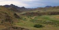
Anyrakay mountains are located at an altitude of 1000 to 1242.6 meters above sea level, are located 43 kilometers southwest of the central part of the Taukum desert, 48 kilometers northeast of the Chu-Ili mountains, 41 kilometers northeast of the Kopa valley, in the southeast of the Zhusandala steppe, in the Korday region in the east Zhambyl region, the southeastern part of the mountains is partially located on the territory of the Zhambyl region in the north-west of the Almaty region.
The Kazakh folk toponym Anyrakay, or Anrakhay, apparently has a rather late origin, as evidenced by the Kazakh folk legends of the late 19th - early 20th centuries, dating the time of its appearance in the historical toponymy of South-Eastern Kazakhstan by the era that followed the expulsion of the Dzhungars from the Kazakh territories they had previously conquered, and the actual absence of any mention of him in written (Eastern, Russian and European) sources of the medieval era.
According to a special historical and toponymic study by scientists E. M. Murzaev, G. K. Konkashpaeva, E. Koichubaea, B. Syulbe.T. Zhanuzak and others, the root basis of the name Anyrakai goes back to the Turkic-Mongolian morphemes ang, anga, angar or angarkhay, which in translation from different Mongolian languages (Mongolian, Oirat, Buryat, etc.) means a gap, a gorge, a crevice, a ravine, crack, etc.
The geographical term angar (atsgar, atsrats. atsrag) has the same semantic content in many modern Turkic languages, including the Kazakh language, where it is usually used to designate canyon-like valleys in the mountains and foothill zones.
This most typical interpretation of the historical toponym Anyrakai is largely consistent with the local climatological version of the origin of this name, which has long been widely used among the Kazakhs - natives of the North-Western Semirechye.
According to the owners of the farm "Abdybek" Malik Abdybekov (born in 1946) and his eldest son Askhat (born in 1972), living in the village of Almaly on the territory of Anyrakai (interview with I.V. Erofeeva and A. Almukambet dated 14 August and September 12, 2005) local Kazakhs for the most part explain it with a loud “weeping-roaring” rumble of wind in the valleys of the Anyrakai mountains - anyrat sokkan zhel “wind blows with a voice”), which is quite often observed in deep mountainous gorges.
Our other informant, Shara Serikova, the widow of Kaunbai Daurenbaev, who lived in the village of Almaly for a long time, confirmed this version; according to her ex-husband, the Anyrakai mountains and area got their name from the strong wind that usually occurs there only in winter and lasts for a week.
“The wind is blowing so hard,” she said, “that it creates a terrible rumble, as if a loud howl is heard. After a week of strong wind, clear and calm weather sets in, resembling calm, and from that time until the end of winter, the pasture on Anyrakai becomes a paradise for livestock and wild animals” (interview with B. N. Kallybekov, September 13, 2007).
This folk etymology is quite convincing and realistic, as it is a certain result of visual and auditory perception and understanding by many generations of nomads of the most obvious natural attractions of the Anyrakay Mountains and the adjacent foothill sloping plain.
The common landscape characteristic of the latter is the presence in their structure of deeply incised canyon-valleys with steep, almost vertical slopes, and in this respect the Anyrakai tract differs markedly from many other natural landscapes of the Chu-Ili region.
The first documentary evidence of the spatial localization of the Anyrakai Mountains is given on two so-called "Kalmyk maps" by the Swedish prisoner of war Johann Gustav Renat (1612 - 1744), who was in the period from 1716 to 1733 in Dzungarian captivity, to which a large scientific literature is devoted.
The most profound studies considering the history of the origin of these maps, their information load and the scientific significance of cartographic materials by Y.G. Renata, were prepared and published in the 19th - 20th centuries. Russian geographer and historian A. I. Maksheev, British orientalist J. Baddeley, his American colleague N. Poppi, Soviet scientists V. I. Grekov and V. I. Volobuev. Thanks to these studies, already at the beginning of the XXth century it was established that one of the two “Kalmyk maps” by J.G. Renata was compiled, apparently, by the Dzungar Khan Galdan-Tszren himself with the help of some unknown European in the historical period from 1711 to 1716. and then copied by the Oirats from the original no later than the end of the 20s. XVIII century.
The Oirot copy of this map was donated by J.G. Renat, in his own words, Galdan-Tsren in Urga. After being released from captivity, he brought her first to Russia, and from there some time later - to his homeland in Sweden.
All the landscape objects of the Semirechye depicted on the map are signed with the Oirat "clear letter", developed by the famous educator Zaya Pandita Namkhai-Jamtso (1599 - 1662) and common among the Oirat nobility, therefore, direct involvement in the creation of a map of the future Dzhungar Khan no doubt.
n St. Petersburg, from the "Kalmyk map" delivered by J.G. Renatom, the Russian cartographer Semyon Starykh made a handwritten copy in 1742, on which he signed the reproduced graphic images in Latin, and placed their Russian translation in Cyrillic below.
In terms of the volume and nature of the geographical information recorded here, the copy of S. Starykh is in fact no different from the Oirat original. The changes were made by the creator only in the shape of the relief image. In particular, the contour lines that indicated on the “Kalmyk map” the natural outlines of mountain ranges visually recorded from a height, were replaced by him with a multitude of cone-shaped hills, which reflected certain traditions of Russian cartography of the late XVIIth - early XVIIIth centuries.
The second edition of the same map was prepared by the mid-30s. XVIII century J.G. Renat. Having significantly improved the Oirat original, in 1738, with the assistance of the translator of the Oirat language of the College of Foreign Affairs V. M. Bakunin, he compiled his own map of Dzungaria called Karta of songarski kalmuskit hwar under kotonerne horer - “Map of Dzungarian Kalmykia, which is subject to cotons”, which subsequently entered the history of European cartography of Central Asia under the name “Maps of I.G. Renata. Unlike the Galdan-Tseren map and its Russian copy compiled by Semyon Starykh, I.G. Renata is painted in several colors and given in the correct projection on all four cardinal points.
It shows the boundaries of the possessions of the Dzungar Khanate, which is not on the "Kalmyk" topographic basis and on the copy of S. Starykh; many more settlements are plotted than in the first two maps, and the locations of the lamaist temples are clearly indicated by special icons, the so-called talters, which are completely absent in the Oirat and Russian versions of the graphic depiction of the territory of Dzungaria.
Received by I.G. Renat from Galdan-Tseren, an exact copy of the original “Kalmyk map” of Dzungaria at the beginning of the 18th century is still little known among historians of the CIS, despite the fact that back in 1919 the English scientist J. Baddeley placed its excellent reproduction in the appendix to the first volume of his fundamental work on the history of cartography of Central Asia.
The scientific community of Kazakhstan is mostly familiar only with the map of I.G. Renata, and according to bad copies published in 1881 in Russia and in 1911 in Germany. The original Oirat map itself and made by I.G. Renat, based on it, a new map of Dzungaria has long been stored in the Department of Maps and Printed Editions of the University Library of Uppsala (Sweden).
Both maps of I.G. Renata are of exceptional value for science, since for the first time in the history of cartography of Central Asia, many natural objects of Semirechye are plotted in them. Eastern and Southern Kazakhstan under their historical names.
They make it possible, with greater or lesser accuracy, to localize the factual information from Russian, Oirat and Chinese sources of the middle of the 17th - first half of the 18th centuries about the places of major military events of that period and to identify the geographical names of the mountains and rivers of the Chu-Ili region found in them with modern toponyms.
On the maps of I.G. Renat, we first meet the left tributary of the Ili River under the name of Almaty (Almatu), where the city of Verny was later founded - modern Almaty; as well as the rivers Kurty (Koton, Kurty), Talgar (Talgar), Shilik (Silick) and Turgen (Turgen) under their historical names.
To the south-east of them, mountains are indicated with the name Khastagan-Daban (Сhastagin Daban), under which the mountainous region with the Kastek pass is easily guessed. Between Kastek and the southwestern coast of Balkhash, the Chu-Ili mountains are quite accurately depicted on the map: Zhambyl (Sambal), Khantau (Chan) and Anyrakai (Ahin-Kodo).
The first two mountain ranges are indicated under their modern names, while the Anyrakai Mountains are named by the term Ahin-Kado, which, translated from the Oirot language, means “field, or pasture, white In the late 50s - mid-60s. In the XIXth century, field studies, topographic surveys and astronomical determinations of points on the earth's surface were carried out in Western Semirechye M. I. Istokov, V. A. Poltoratsky, A. F. Golubev, V. A. Struve, Ch. Ch. Valikhanov and some other researchers.
Thanks to their research, the Anyrakai Mountains and the valleys of the Kopala and Sarybulak rivers cutting through them were clearly marked for the first time in the cartography of this region, and the mountains, in addition, were named in writing on the forty-verst line drawn up in 1868 by the staff captain of the Corps of Military Topographers M. G. Lyusilin " Map of the Turkestan Governor General).
In the second half of the 19th - early 20th centuries, the Anyrakai section of the Chu-Ili mountain system was more or less thoroughly examined by botanists A.N. Krasnov (1886) and M.I. Ptashitsky, statisticians V.E. Nedzvetsky (1909) ) and P. P. Rumyantsev (1911), geologist B. F. Meffert (1910), soil scientists A. I. Bessonov and G. M. Tumin (1914), geographer R. I. Abolin ( 1916) and some other scientists, but there is practically no specific information about the natural boundaries and natural sights of the Anyrakai historical area in their published scientific articles and reports on field research.
In direct connection with the history of the Kazakh-Oirat wars, the natural landscapes of the Anyrakay mountains and adjacent foothill and plain zones of the Western Semirechye (Zhambyl district of Almaty region, Moyinkum and Shu districts of Zhambyl region) began to be explored only after the collapse of the Soviet Union and the formation of a sovereign Republic of Kazakhstan.
Geographic coordinates of Anyrakai Mountains: N43°59'22.11" E75°12'25.21"
Authority:
"Anyrakay Triangle Historical-Geographical Area and Chronicle of the Great Battle". I.V. Erofeeva, B.Zh. Aubekerov, A.E. Rogozhinsky, B.N. Kaldybekov, B.T. Zhanaev, L.L. Kuznetsova, R.D. Sala, S.A. Nigmatova, J.M.P. Deom. Almaty, 2008. "Dyke Press".
Photos by
Alexander Petrov.