


![]()
You are here
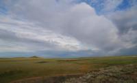
Anyrakai valley.
Tourist routes in Zhambyl region.
“How beautiful life is, by the way, and because a person can travel”
I. A. Goncharov.
Guide to historical monuments of Zhambyl region.
The Anyrakai valley is located at an altitude of 630 to 700 meters above sea level, located in the northern part of the Anyrakai Mountains, most of the tract is located in the Kordai district of the Zhambyl region, a small part of the western part of the tract is located in the Zhambyl district of the Almaty region.
he Anyrakai valley is located in the interfluve of drying river channels: in the east of the salty channel of the Ashchysu, which stretches from south to northeast, in the west the channel of Ketlenkaldy stretches from south to north.
On the territory of the valley there are also several drying channels: Kopaly, Karakemer and Sarybulak originating in the northern spurs of the Anyrakai mountains. In the east, the valley is bounded by the Shoaldyr mountains with a dominant height of 697 meters above sea level.
From the west, the valley is bounded by mountains: Zhyngyldy with a dominant peak 663.9 meters above sea level, Saksayrek with an unnamed peak 674.9 meters above sea level. In the south-west of the tract there are mountains: Dosugul with the peak of the same name 866 meters above sea level and Ketpen-Kaldy with the dominant peak 891.1 meters above sea level.
In the northeastern part of the valley, 11 kilometers away, is the Kalmyktobe fortification, which in the period from 1720 to 1730 was a stronghold of the Dzungarian troops. In the spring of 1730, a historic battle took place between the Kazakh militia and the Dzungarian army in the Anyrakai valley.
Geographic coordinates of Anyrakai valley: N44°05'49.45" E75°11'55.58"
Authority and photos by
Alexander Petrov.