


![]()
You are here
Copper path from Zhosaly to Karsakbay.


British were building a railway from Zhosala to Karsakbay.
“In the second half of the 2nd millennium BC. Central Kazakhstan has become one of the important centers of metallurgy on the Eurasian continent.”
A.H. Margulan.
Trip along steppe road from Zhosala to Karsakbay.
The length of the route from the Zhosaly station to the village of Karsakbay, along which the British transported goods for the construction of the Karsakbay copper smelter along a temporary narrow-gauge railway between 1914 and 1917, is 342 kilometers.
In 1925, Atbastsvetmed launched a steppe road along this route for cars and horse-drawn vehicles from Karsakbay to Zhosala. 18 adobe pickets were built on the road. Warehouses for food, fuel and lubricants were built here.
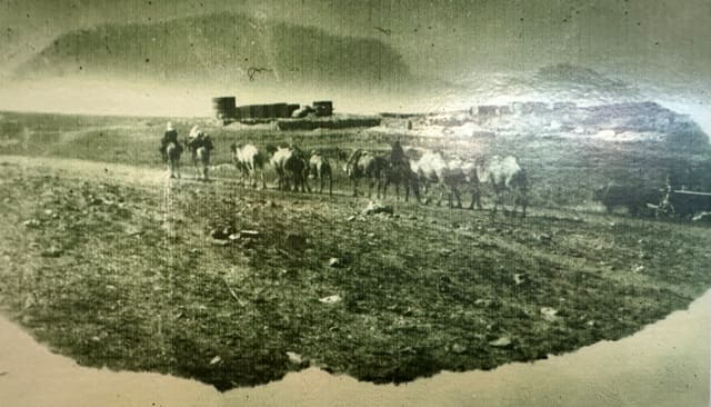
Along this route, equipment for the Karsakbay copper smelter was delivered to Karsakbay by cars, camels and horses. Cargo transportation was mainly carried out on camels, of which about 12,000 were prepared for such work.
In October 1928, the Karsakbay copper smelter began producing blister copper, which was transported along the steppe road from Karsakbay to the Zhosalydal station, mainly on camels. The first 103 kilometers of the route run from Zhosaly to the Kumkol oil field or to the beginning of the western tip of the Kyzylkiya cliffs to the northeast.
From this section of the path in the southeast there is the Daryalyktaki plain, in the east lies the Shengeldy rubble, further in the east are the sands of Arys Kum. At the end of 103 kilometers in the northwest are the southeastern spurs of the Borioainak ridge with heights of up to 288 meters above sea level.
The remaining 239 kilometers of the route also go northeast to the village of Karsakbay. Part of the path passes along the Kyzylkiya chinks, which are located in the western part. It crosses the bed of the Kalmakkyrgan River and the western spurs of the Nura ridge, which is located to the east.
To the Koktal picket, the path has a north-northeast direction and then the direction continues northeast to the village of Karsakbay. In this area, the markings of pickets have been preserved on the 200,000 scale topographic map. For example, there are ruins of picket No. 6 located at an altitude of 228 meters above sea level.
Geographic coordinates of picket No. 6: N46°21'14.42" E65°05'41.97"
Further, after 19 kilometers, there are the ruins of picket No. 7 located at an altitude of 239 meters above sea level.
Geographic coordinates of picket No. 7: N46°27'32.12" E65°16'20.88"
Further, after 15 kilometers, there are the ruins of picket No. 8 located at an altitude of 215 meters above sea level.
Geographic coordinates of picket No. 8: N46°32'25.19" E65°26'04.53"
Almost in the middle between pickets 6 and 7 in the vicinity of the Kyzylkiya tract lies the administrative border between the Kyzylorda and Ulytau regions. After 18 kilometers there is picket No. 148 located at an altitude of 224 meters above sea level.
After 41 kilometers we see on the map picket No. 11, which has the name Ak-Mula and is located on the right bank of the Kalmakkyrgan River. The picket is located at an altitude of 211.6 meters above sea level.
Geographic coordinates of picket No. 148: N46°38'57.04" E65°36'16.40"
After 47 kilometers, on the right bank of the Koktal River there is a picket “Koktal” located at an altitude of 315 meters above sea level.
Geographic coordinates of the Koktal picket: N47°20'23.53" E66°05'10.11"
After 15 kilometers there is a picket “Kara-Bulak” located at an altitude of 337 meters above sea level, on the right bank of the Aschymuyir River.
Geographic coordinates of the Kara-Bulak picket: N47°26'30.60" E66°12'10.26"
After 46 kilometers there is peak No. 18. From the picket to the village of Karsakbay - 17 kilometers. The picket is located at an altitude of 496 meters above sea level
Geographic coordinates of picket No. 18: N47°45'14.44" E66°32'51.82"
Authority:
Alexander Petrov.
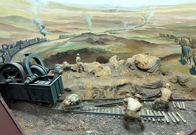
“With the outbreak of the First World War, the demand and prices for copper increased sharply. This accelerated work on the construction of a copper smelter in Karsakpai. In the summer of 1915, the installation of trusses and floors for the smelting shop and processing plant began.
Construction was significantly hampered by the lack of a railway. It was necessary to connect the coal mines and the plant with a railway track. Transportation by tug to Karsakpai of ore from Dzhezkazgan and coal from Baikonur amounted to 14 kopecks per pood.
To connect the mine and mines with the plant by railway, after survey work, in the spring of 1915, construction began on a narrow-gauge railway with a total length of 120 versts. Stations were built in Karsakpai, Baikonur, and Dzhezkazgan.
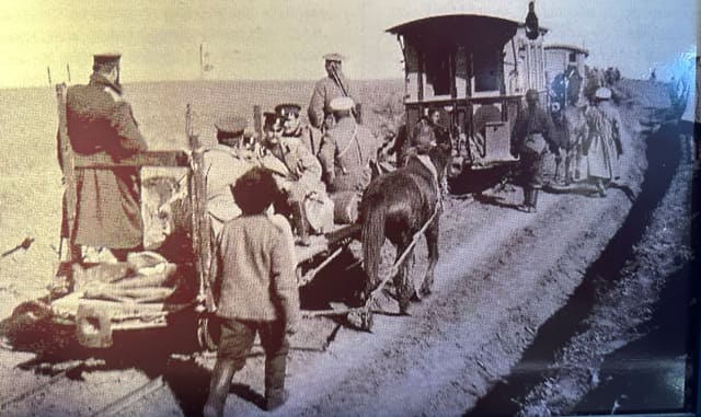
It was necessary to connect the Atbasar industries with the Tashkent railway, the nearest station of which was Dzhusaly (Zhosaly). This transshipment base is located 400 kilometers from Karsakpay. Here the British rented a plot of land, built warehouses, workshops, and living quarters.
About 1,000 carts were purchased to transport goods to the plant. To transport goods, drivers from the local population with their own camels and horses were hired. Along the road, 15 - 20 kilometers away, pickets were created with the necessary supplies of food, water, and fodder.
Delivery of one pound of cargo cost the Company 60 kopecks. At the Dzhusaly station, several hundred thousand pounds of various large-sized cargo accumulated - equipment for the Karsakpai plant, which could not be transported by horse-drawn vehicles.
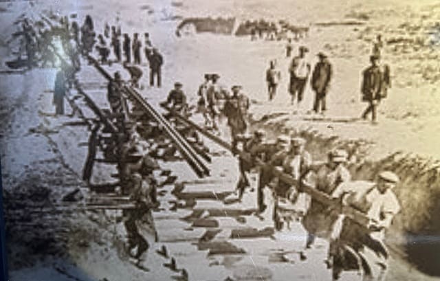
It was necessary to build the Dzhusaly-Karsakpai railway, which required huge capital expenditures. The British took a different route. From Dzhusaly station on the way to Karsakpai the first 13-verst section of the railway was laid.
Five locomotives and 278 cars were mounted on it, occupying 2.5 miles of track. The carriages were loaded with 200,000 pounds of cargo. After moving the rolling stock to the front end of the railway, the free 10.5 km of rail track was remounted, and the caravan of locomotives and wagons moved forward to Karsakpai another 10.5 km.
Thus, the British expected to complete the entire journey in a year. The caravan set off on November 10, 1914 along a narrow-gauge railway, and arrived in Karsakpai on October 8, 1917, that is, three years later. The equipment that arrived was quickly installed.
However, the revolution and subsequent civil war radically changed the course of events. The British failed to complete the construction of the Karsakpai plant. They left the Kazakh steppes for a long time.”
Authority
Novikov Vladimir Yakovlevitch. http://novikovv.ru/kanish-satpaev/vtoroe-rozhdenie-zhezkazgana
To XXth anniversary of 1916 uprising in Kazakhstan.
On Karsakpai "Caravan". Memoirs of a Baikonir worker.
«Litvinov's office was widely known among Karsakpai workers as a company of large contractors and extraordinary swindlers. She was engaged in the delivery of goods from the Dzhusaly station to Karsakpai via a switch railway, for some reason called a “caravan”.
The caravan had 20 kilometers of rail track and 2-3 low-power locomotives. The work was carried out as follows:
They laid 20 kilometers of rails and transported goods along them. Then the transportation stopped and the rails were transferred further. Within a month, they managed to transfer cargo in this way only at a distance of 200 kilometers.
There were very few skilled workers on the “caravan”. The bulk of the workers consisted of Kazakhs and were used for menial work. Once - it was at the end of the summer of 1915, the driver, while loading the rails, carelessly pulled the locomotive.
Twenty-five workers who were carrying a rail link at that time fell and some of them hurt their arms and legs. The workers turned to the office for medical help. Instead of iodine, their wounds were covered with salt, which caused incredible pain.
The next morning, the indignant workers did not go to work. The guards began to drive them out of the barracks with whips. The workers chased away the guards and headed out of the office. The frightened owner fled by car to Karsakpai.
The workers demanded immediate payment of wages and an invitation to a doctor. The strike lasted for two days. On the third day, a truck arrived with three elders, a bailiff, a policeman and two guards. The elders “persuaded” the workers, and in the meantime the bailiff arrested 10 of the most active strikers.
In May 1916, a strike broke out again. This time due to the fact that no bread was given out for a number of days. The workers surrounded the office and began demanding bread and payment. The owners refused both.
Then the workers opened the food car, which was intended for high-ranking employees, and began to take rice, millet, sugar, tea and other products from there. They distributed all this among themselves according to a certain norm.
The strike lasted 3 days, after which some received payment and left. In July–August, when it became known about the mobilization for rear work and the armed uprisings being prepared under the leadership of Amangeldy Imanov in the Turgai steppes, Kazakh workers left the “caravan” in droves and went to the steppe to join the rebel detachments.
I would also like to mention one strike on a “caravan” that broke out in the summer of 1917. The workers made a number of demands, including the demand that the guards be removed immediately. “If you don’t remove them, then we will remove them ourselves,” the workers said.
The guards were removed. On October 1, 1917, the cargo, the shipment of which began from Dzhusaly station in November 1914, was finally delivered to Karsakpai. On this occasion, a drinking party began among the senior administration...
A great proletarian revolution was approaching throughout the country.»

Author:
Syroezhkin. "Kazakhstanskaya Pravda". July 30, 1936.
Photos by:
Black and white photographs were used from the Historical and Industrial Museum named after K.I. Satpayev LLP "Corporation Kazakhmys" of the city of Zhezkazgan.