


![]()
You are here
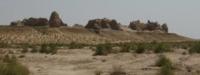
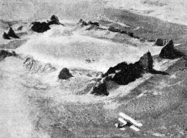
Ancient settlement Kurgashin kala.
Tour to Uzbekistan.
“Both in the east and in the west of the world there are no melons similar to the Khorezm melons, with the exception of the Bukhara melon, followed by the Isfahan melon ... It is surprising that it is cut into pieces, dried in the sun and put in baskets, as we do with dried figs and Malaga figs, and they are taken from Khorezm to the distant cities of India and China..."
Ibn Battuta.
Group excursions in Uzbekistan.
The Kurgashin kala settlement is located on a natural hill 101.8 meters above sea level, located in the southwest of the Kunzheken takyr in the southern part of the Kyzyl Kum sands, 7.1 kilometers northwest of Mount Kokcha, 169.1 meters above sea level. 8 kilometers north and slightly west of the village of Kokcha, 40.2 kilometers north-east of the village of Allikkala in the Ellikala region of the Republic of Karakalpakstan.
The fortress Kurgashin kala is well preserved, and some towers still stand up to the height of the second floor. It covers an area of 1.4 hectares. Kurgashin kala was built in the IVth - IIIrd centuries BC. and existed as a populated city until the IVth century AD.
The walls were built of pakhsa in the lower part, followed by a masonry of square bricks with tamga. The fortress is surrounded by a barrier wall from all sides, except for the south-western one. The fortress probably covered the inner regions of the ancient Khorezm state from the invasion of the steppe tribes.
The fortress has a rectangular shape. The walls are of double thickness with a central corridor, the outer surface is pierced with loopholes. The defense was enhanced by a combination of round and rectangular towers.
This fortress is unusual in its combination of round and rectangular defensive towers and in the different processing methods used in each corner. The gate was in the center of the southeastern wall and was defended by a defensive barbican. Advanced defensive structures strengthen the fortress's defenses.
The fortress was located in a strategically important area and protected the northeastern section of the ancient Khorezm state. As local shepherds say, the name of the fortress comes from the Turkic word meaning "lead", which was supposedly mined near this place.
Several large farms with houses, barns, fields, canals and large vineyards were located right next to the fortress.
Geographic coordinates of the settlement Kurgashin kala: N42 ° 02'03.49 "E61 ° 19'20.34"
Authority:
"In the footsteps of the ancient Khorezm civilization." Tolstov S.P. 1948.