


![]()
You are here
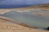
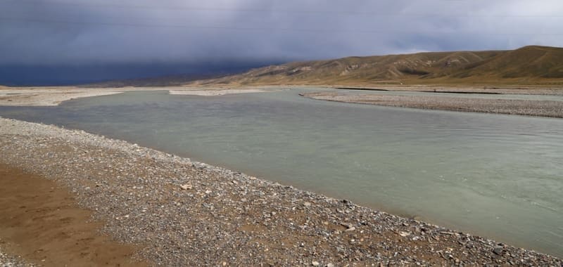
Aksai Western river.
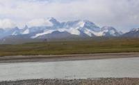
Rivers and lakes in Kyrgyzstan.
“The Aksai flows at the foot of the Kok-Kiya ridge and then enters a narrow gorge between this ridge and Bos-adyr; I assumed its level at the entrance to the gorge, based on the extremely low half-foot alpine willow, to be about 10,000 feet and not lower than 9,800 feet; according to Captain Kaulbars’s barometric measurement, it was about 10,000 feet, which is entirely consistent with the measured height of Tas-Asu and gives about 11,500 feet of absolute height for October snow under the Kok-Kiya peaks, 13,500 feet or even 14,000 feet for eternal snow, and 17,000–18,000 feet for the highest peaks of Kok-Kiya; others were 15,000–16,000 feet. and Bos-adyr about 15,000 feet or even a little lower."
"Travel through the Turkestan region and exploration of the mountainous country of Tien-Shan." N. Severtsov. 1873.
Then we went down to the Aksai River. The riverbed here is very wide, more than 1 verst, and is divided into channels, thanks to which fording is safe. The water in the river is clean. The sandy riverbed is overgrown with various plants, however, all small and creeping along the ground. The calm and clean Aksai River somehow did not resemble mountain rivers. There were no rocks anywhere to be seen, only below our crossing several huge boulders - rocks were visible along the riverbed. Having crossed the Aksai, we began to climb along its high right bank, i.e. along the northern slopes of the foothills of the Aksai Tien Shan. The grass here was especially good.
"Through the mountainous regions of Russian Turkestan". V. I. Lipsky. 1906.
Rivers in Kokshaal-Too mountains.
Western Aksai River is formed at an altitude of 3537 meters above sea level from confluence of rivers: Bulak and Bulak Vostochny. Length of river is 107 kilometers from its source to confluence of Western Aksai with Mudyurum River. Merging together, rivers flow in one stream for 1.5 kilometers and soon Kekkiya tributary flows in from right and after that river gets name Kokshaal. River flows through territory of At-Bashinsky district, in Naryn region.
It originates from the southern slopes and glaciers of the At-Bashi ridge and the northern slopes of the Kokshaal-Too ridge, Meydantag. Kek-Kyya, Kel-Tau, Sarybel, Karakyr and the eastern slopes of the Torugart-Too ridge. The catchment area is 7440 square kilometers. The main source of food is melt, snow and glacial waters. The flood begins in July and ends in September. The average annual water flow is 9.3 meters per second.
Detailed hydrography of Aksai West River.
Sources of Western Aksai River.
The sources of the Western Aksai include two rivers - Bulak and Bulak Vostochny, which originate in the western spurs of the Torugart-Too ridge. The Western Aksai River in its upper reaches is called Bulak, at the confluence of the right tributary of the Bulak East, the river receives the name Western Aksai.
Bulak river.
The drying bed of the Bulak River, 13.5 kilometers long, originates in the western spurs of the Torugart-Too ridge at an altitude of 3834.2 meters above sea level.
Geographical coordinates of Bulak River: N40°42'21 E75°36'46
Bulak East river.
The 12.5-kilometer dry and unstable bed of the Bulak Vostochny River originates in the western spurs of the Torugart-Too ridge at an altitude of 3852 meters above sea level. The mouth of the river is located at an altitude of 3524 meters above sea level.
Geographical coordinates of Bulak East River: N40°41'39 E75°38'55
The sources of the Western Aksai River border on the watershed of the rivers of the Chatyr-Kol Lake basin and the Kokshaal River basin. The watershed starts from the western spurs of the Torugart-Too range from the sources of the Bulak River and is directed to the northeast. It extends to the west of the peak of Kensu with a height of 3739.7 meters above sea level, then continues to the north and northwest to the southern slopes of the Atbashi ridge, between the Kekaigyr rivers in the west and the full-flowing Kensu river in the east.
It should be noted that on topographic maps the river is called Aksai. At the same time, in the eastern part of the Aksai valley, from the confluence of the Karagermes and Chochorganak rivers, the Aksai river is also formed, at the confluence of the Kashka-Su tributary on the right, and on the left of the Kogart, the river gets the name Moduryum.
To eliminate confusion in the names of the rivers of the same name, I added to the river of the western formation West further West Aksai, to the river flowing from the east - East further East Aksai. Western Aksai River has a length of 107 kilometers, flows through a wide valley in an easterly direction, and is located on the territory of the At-Bashinsky district of the Naryn region.
Geographical coordinates of Aksai West River: N40°51'54 E76°12'46
Right tributaries of Western Aksai.
Chingyrsay river.
The drying and unstable channel of the Chingyrsai River, 15 kilometers long, flows into the Western Aksai on the right at 19 kilometers after its beginning. The sources of the river are located at an altitude of 3830 meters above sea level. The mouth of the river is located at an altitude of 3493 meters above sea level.
Geographic coordinates of Chingyrsay River: N40°41'36 E75°41'07
River Karasai Western.
The drying and unstable channel of the Karasai Western River, 27 kilometers long, flows into the Western Aksai on the right at 21.2 kilometers after its beginning. The sources of the river are located at an altitude of 3830 meters above sea level. The mouth of the river is located at an altitude of 3510 meters above sea level. On the right side, the river has 5 on the left 22 large and small drying tributaries.
Geographical coordinates of Western Karasai River: N40°36'55 E75°42'44
Terek river.
he full-flowing channel of the Terek River, 64 kilometers long, flows into the Western Aksai on the right at 39 kilometers after its beginning. This is one of the long rivers of the right tributaries of the Western Aksai. The river has numerous right and left tributaries.
The sources of the river are located on the southern side of the Terek pass at an altitude of 3908 meters above sea level. The mouth of the river is on height of 3308 meters above sea level. On the right side the river has 5 dry tributaries, on the left side there are 22 large and small dry tributaries.
Geographic coordinates of Terek River: N40°38'13 E75°55'23
Basin of Terek River - Urtasu
Left tributaries of Terek River are the Urtasu.
River Otto-Tsch.
The drying and unstable bed of the Otto-Tash River, 8 kilometers long, flows into the Terek on the left at 49 kilometers after its sources. The river is formed at an altitude of 3484 meters above sea level from several tributaries.
he sources of the river are located at an altitude of 3830 meters above sea level. From the west, drying tributaries flow into Otto-Tash: Karasai-1 with a length of 22 kilometers and Karasai-2 with a length of 24 kilometers. To the east, tributaries flow into Otto-Tash: Karasu-1, 24 kilometers long.
The Karasu-1 river receives a small tributary Karasu-2 with a length of 6.5 kilometers. All western and eastern tributaries cross the Balykty-Zhok tract in the middle reaches. The mouth of the river is located at an altitude of 3387 meters above sea level. Otto-Tash has numerous right and left drying tributaries.
Geographic coordinates of Otto-Tash River: N40°39'21 E75°51'25
Saryimek river.
The 51-kilometer-long dry and unstable bed of the Saryimek River flows into the Terek on the left at an altitude of 3475 meters above sea level. The river flows to a height of 3528 meters above sea level in a full-flowing stream, and when it reaches a flat area, it loses its full-flowing, begins to filter and go into underground channels.
Also, up to this height, the river from the beginning of its sources has a name - Lyuutyr. The Lyuutyr River originates from the southern slope of the Sermendavan pass, 3971 meters above sea level, located in the main ridge of the Karakyr ridge.
One of the full-flowing left tributaries of the Lyuutyr River starts from the Kyzyl-Kur pass, 3805.8 meters above sea level, located in the main ridge of the Karakyr ridge. The mouth of the river is located at an altitude of 3475 meters above sea level. Sariiyymek has numerous right and left drying tributaries.
Geographical coordinates of Saryijmek River: N40°33'07 E75°50'59
Urta-Su river.
The full-flowing channel of the Urta-Su River, 31 kilometers long, flows into the Terek on the left at an altitude of 3514 meters above sea level. The river originates from the pass of the same name, 3965 meters above sea level, located in the main ridge of the Meydantag ridge. The mouth of the river is located at an altitude of 3514 meters above sea level. Urtasu has 13 tributaries on the right and 7 tributaries on the left.
Geographic coordinates of Urta-Su River: N40°27'56 E75°49'57
Tepshi river.
At the 16th kilometer from the beginning of the sources, the Tepshi tributary, 16 kilometers long, flows into the Urtasu from the left. In the upper reaches, the river forms the main channel of 3 tributaries, which originate from a height of 4340 and 4321 meters above sea level.
The above heights are located in the main ridge of the Meydantag ridge. The mouth of the river is located at an altitude of 3676 meters above sea level. Tepshi has 7 tributaries on the right and 7 tributaries on the left.
Geographical coordinates of Tepshi River: N40°24'25 E75°46'33
Right tributaries of Terek River are Urta-Su.
In the upper reaches of the Urta-Su River, on the right side, 4 logs adjoin it, which are river channels for small rivers: the Kara-Zhylga log with a length of 9.5 kilometers, the Orta-Zhylga log with a length of 15 kilometers. The mouth of the Orta-Zhylga River is located at an altitude of 3579 meters above sea level. Log Chetkor-Zhylga is 14 kilometers long, its mouth is located at an altitude of 3579 meters above sea level.
Kipchak river.
At an altitude of 3523.9 meters above sea level, a tributary of the Kipchak, 29 kilometers long, flows into the Terek River on the right. The sources of the river begin from the southern side of the pass of the same name, 3922 meters above sea level, which is located in the main crest of the Meydantag ridge. The main channel of the river is formed at an altitude of 3751.7 meters above sea level from two tributaries.
Geographical coordinates of Kipchak River: N40°25'07 E75°58'27
Tysbel-Kenkor river.
At an altitude of 3523.9 meters above sea level, a 34-kilometer-long tributary Tysbel-Kenkor flows into the Terek River on the right. The sources of the river begin from the northern slope of the Meydantag ridge at an altitude of 4550.9 and 4517.5 meters above sea level. The main channel of the river is formed at an altitude of 3765.8 meters above sea level from two main tributaries.
At an altitude of 3657.3 meters above sea level, the tributary Kurchak- Kyzyl-Su, 22 kilometers long, originates at an altitude of 4253 meters above sea level from the northern slope of the Meydantag border ridge.
Geographic coordinates of sbel-Kenkor River: N40°26'47 E76°01'03
Kyzyl-Suu River (Ichke-Kyzyl-Su).
The full-flowing Kyzyl-Su River, 22 kilometers long, flows into the Western Aksu River on the right at 52 kilometers after the beginning of its sources. The main channel of the river is formed at an altitude of 3479.9 meters above sea level.
The river has several large and small tributaries. On the left, the river receives a tributary of the Kurchak-Kyzyl-Su, on the right, the Ichke-Kyzyl-Su (Botogoztok). In the middle course, the river flows through the Dzhilusu tract.
Geographical coordinates of Kyzyl-Su River (Ichke-Kyzyl-Su): N40°41'20 E76°03'51
Rivers of Kyzyl-Suu (Ichke-Kyzyl-Su) basin.
River Ichke-Kyzyl-Su (Botogoztok).
The Ichke-Kyzyl-Suu River, 32 kilometers long, flows into the Kyzyl-Su River on the right 6 kilometers before it flows into the Western Aksai River. The river originates in the interfluve of Tekelik and Orta-Kyzyl-Suu at heights of 4299.5 and 4266.5 meters above sea level on the northern slope of the western tip of the Kokshaal-Too ridge.
In the upper reaches, the main channel of the river is formed at an altitude of 3733.7 meters above sea level from two main tributaries. The mouth of the river is located at an altitude of 3363 meters above sea level.
Geographical coordinates of river Ichke-Kyzyl-Suu: N40°40'09 E76°07'14
Kurchak-Kyzyl-Suu River
The Kurchak-Kyzyl-Suu River, 35 kilometers long, flows into the Kyzyl-Su from the left 10 kilometers before its confluence with the Western Aksai River. The river originates at an altitude of 3962.1 meters above sea level in the interfluve of Chet-Kyzyl-Suu and Terek.
The main channel of the river is formed at an altitude of 3392 meters above sea level. Up to this height, the river has many intermittent and intermittent tributaries. Many tributaries flow in deep ravines, ravines and crevices. The mouth of the river is located at an altitude of 3363 meters above sea level.
Geographical coordinates of Kurchak-Kyzyl-Suu River: N40°41'04 E76°02'06
Chet-Kyzyl-Su river.
The Chet-Kyzyl-Su River, 32 kilometers long, is the beginning and generatrix of the Kyzyl-Su River 22 kilometers before its confluence with the Western Aksai River. The river originates at heights of 4550.9 and 4435 meters above sea level in the eastern tip of the Meydantag ridge in the interfluve - from the west of Kentor and from the east of Orta-Kyzyl-Su.
In the upper reaches, the main channel of the river is formed at an altitude of 3777.4 meters above sea level from two tributaries. The mouth of the river is located at an altitude of 3470.9 meters above sea level.
Geographical coordinates of Chet-Kyzyl-Su River: N40°38'37 E76°04'00
Orta-Kyzyl-Su river
The Orta-Kyzyl-Su River, 33 kilometers long, is the beginning and generatrix of the Kyzyl-Su River 34 kilometers before its confluence with the Western Aksai River. The river originates from the western slope of the Orkash-Kakashu pass, 4189.7 and 4435 meters above sea level, which is located between the eastern end of the Meydantag ridge and the western end of the Kokshaal-Too ridge.
In the upper reaches, the main channel of the river is formed at an altitude of 3817 meters above sea level from several tributaries. The mouth of the river is located at an altitude of 3470.9 meters above sea level.
Geographical coordinates of Orta-Kyzyl-Su River: N40°35'48 E76°08'46
River Kara-Batyr (Konkoy).
The Kara-Batyr River, 29 kilometers long, flows into the Western Aksai River on the right at 54.7 kilometers. The river originates in the interfluve of Tekelik and Ichke-Kyzyl-Su from the northern slope of the western tip of the Kokshaal-Too ridge at heights of 3841 and 3806.5 meters above sea level.
In the upper reaches, the main channel of the river is formed at an altitude of 3502.3 meters above sea level from several tributaries. In the middle reaches, the river flows through the Karabudur tract. The mouth of the river is located at an altitude of 3255 meters above sea level.
Geographic coordinates of Kara-Batyr River: N40°43'12 E76°09'01
Tekelik river.
The full-flowing Tekelik River, 51 kilometers long, is one of the longest, flows into the West Aksai River on the right at 65.4 kilometers from the beginning of its sources. The river originates between the Tarash and Ichke-Kyzyl-Su rivers from the northern slope of the western tip of the Kokshaal-Too ridge at an altitude of 4400 meters above sea level.
At an altitude of 3439.5 meters above sea level, the river receives a 12-kilometer-long tributary Karabel on the right. In the upper reaches, the main channel of the river is formed at an altitude of 3674.9 meters above sea level from several tributaries. In the middle reaches, the river flows in the eastern part of the Karabudur valley. The mouth of the river is located at an altitude of 3178.3 meters above sea level.
Geographical coordinates of Tekelik River: N40°40'42 E76°11'57
Tributaries of Tekelik River Basin.
Karabel river.
The full-flowing Karabel River, 12 kilometers long, flows to the right at 28 kilometers into the Tekelik River at an altitude of 3439.5 kilometers from the beginning of its sources. The river originates from the Sarybeles glacier, 2.5 kilometers long. The upper border of the glacier starts from the top of Sarybeles, 4650 meters above sea level. The glacier is located on the northern slope of the Sarybeles ridge. The mouth of the river is located at an altitude of 3439.5 meters above sea level.
Geographic coordinates of Karabel River: N40°40'27 E76°14'55
Ortosu river.
The Orthosu River, 17 kilometers long, flows into the Tekelik River from the right at 25 kilometers from the beginning of its sources. The river originates from the western slope of the Karabel pass with a height of 4023.1 and a height of 4299.6 meters above sea level.
Two small rivers flow into the western tributary on the left: the Tashty-Bulak, 4.5 kilometers long, and the Tuyuk-Tor, 5.5 kilometers long. Both rivers originate at an altitude of 4150.2 meters above sea level. The main channel of the river is formed at an altitude of 3557 meters above sea level from the western and eastern tributaries. The mouth of the river is located at an altitude of 3488 meters above sea level.
Geographic coordinates of Ortosu River: N40°38'16 E76°15'59
Tarashu river.
The Tarashu River, 13 kilometers long, flows into the Tekelik River from the right at 14.5 kilometers from the beginning of its sources. The river originates at an altitude of 4510 meters above sea level. The main channel of the river is formed at an altitude of 3953.3 meters above sea level.
The mouth of the river is located at an altitude of 3674.9 meters above sea level. At the 6th kilometer after the sources, a small tributary of the Tyuzbel with a length of 2.2 kilometers flows into Tarash on the right. Tyuzbel originates at an altitude of 4366.3 meters above sea level and flows west to the mouth past the Tyuzashu pass with a height of 3933.1 meters above sea level.
A small tributary of the Tura-Zhylga with a length of 4.3 kilometers flows into the Tarasha River on the right at 11 kilometers after its beginning. The sources of the river are located at an altitude of 4299.6 meters above sea level.
Geographical coordinates of Tarashu River: N40°33'45 E76°20'38
Tekesu river.
The Tekesu River, 27 kilometers long, flows into the Western Aksai River from the right at 72 kilometers from the beginning of its sources. The river originates at an altitude of 3917.5 meters above sea level among rocky outliers, some of which reach a height of 7 meters.
The main channel of the river is formed at an altitude of 3425.4 meters above sea level. The mouth of the river is located at an altitude of 3160 meters above sea level.
Geographic coordinates of Tekesu River: N40°47'57 E76°13'22
Bolshay Kuldzha-Bashi river.
The Bolshoy Kuldzha-Bashi River, 26.5 kilometers long, flows into the West Aksai River from the right at 72 kilometers from the beginning of its sources. The river originates from the northern slope of the Sarybeles ridge at an altitude of 4726.6 meters above sea level.
The main channel of the river is formed at an altitude of 3322 meters above sea level. The mouth of the river is located at an altitude of 3160 meters above sea level. A road was laid along the river to the alpine lake Kel-Suu, located at an altitude of 3530 meters above sea level.
Geographical coordinates of river Big Kuldzha-Bashi: N40°47'55 E76°16'04
River Malaya Kuldzha-Bashi.
The drying river Malaya Kuldzha-Bashi, 19 kilometers long, flows into the Western Aksai River from the right at 82 kilometers from the beginning of its sources. The river originates from the western slope of the Sarybeles ridge at an altitude of 3717.8 meters above sea level and from the Kekkiya pass located at an altitude of 3620 meters above sea level. The main channel of the river is formed at an altitude of 3265 meters above sea level. The mouth of the river is located at an altitude of 3135 meters above sea level.
Geographical coordinates of river Malaya Kuldzha-Bashi: N40°49'44 E76°17'42
Kekkiya river.
The full-flowing channel of the Kekkiya River, 44 kilometers long, flows to the right at 107 kilometers into the Western Aksai River from the beginning of its sources. The river is the second longest after the Tekelik River, which flows into the Western Aksai from the right.
The river has complex hydrography and is one of the components of the Kokshaal River. The main channel of the river is formed at an altitude of 3328 meters above sea level. On the left bank of the river there is a small shepherd's village, tent and yurt camps of tourist companies of Kyrgyzstan, which offer services for accommodation and walks to the local natural attraction - Lake Kel-Suu, located at an altitude of 3530 meters above sea level.
The river is formed from two large tributaries: the left tributary - the Kurumduk River, which flows from the western slope of the pass of the same name with a height of 3795.5 meters above sea level, located at the western end of the Kokshaal-Too ridge and flows through Lake Kel-Suu.
The Tuyuk-Botomoinok tributary, 30 kilometers long, receives the Kekkiya from the right. The mouth of the Kekkiya River is located at an altitude of 2980 meters above sea level.
Geographical coordinates of Kekkiya River: N40°51'14 E76°28'02
Right tributaries of Kekkiya River.
Suesh river.
After 10.3 kilometers from the beginning of the formation of the Kekkiya riverbed, a small tributary of the Suesh, 5 kilometers long, flows in from the right. The sources of the river are located at an altitude of 3815.1 meters above sea level. The river is located between the Sumasary and Aksayuru rivers.
Geographic coordinates of the Suesh River: N40°45'28 E76°25'38
Tarash river.
After 7.4 kilometers from the beginning of the formation of the Kekkiya riverbed, a small tributary of the Tarash, 5.4 kilometers long, flows in from the right. The sources of the river are at an altitude of 3622 meters above sea level.
Geographical coordinates of Tarash River: N40°46'56 E76°25'46
Aksayuru river.
After 32 kilometers from the beginning of the formation of the channel of the Kekkiya river, a large tributary of the Aksayuru with a length of 31 kilometers flows from the right. The sources of the river begin from the western slope of the Chon-Uru pass, 4096.4 meters above sea level, located in the main ridge of the Kokshaal-Too ridge.
The river on the right has 19 and on the left 6 tributaries. One of the right, unnamed tributaries of the Aksayuru River originates from the westernmost glacier located on the southern slope of the Kekkyya ridge. The length of the glacier is 2.5 kilometers.
Geographical coordinates of Aksayuru River: N40°44'47 E76°32'40
Left tributaries of Kekkiya River.
Kurumduk river.
The Kurumduk River, 52 kilometers long, merges with the right tributary of the Tuyuk-Botomoinok and thus forms the Kekkiya River. Kurumduk is the longest river of the left tributaries of the Kekky. Kurumduk has 27 large and small tributaries on the left. For 13 kilometers, the river carries its waters through Lake Kel-Suu.
The sources of the river are received from the western slope of the pass of the same name located at an altitude of 3795.5 meters above sea level, which is located in the main ridge of the western tip of the Kokshaal-Too ridge.
In the upper course, the river flows through the Uchchat valley. The main channel of the river is formed at an altitude of 3328 meters above sea level. On the left bank of the river there is a small shepherd's village, tent and yurt camps of tourist companies of Kyrgyzstan, which offer services for accommodation and walks to the local natural attraction - Lake Kel-Suu, located at an altitude of 3530 meters above sea level.
The river is formed by two large left tributaries - the Kurumduk River and the Tuyuk-Botomoinok tributary, 30 kilometers long, which Kekkiya receives on the right. The mouth of the Kurumduk River is located at an altitude of 3325 meters above sea level.
Geographic coordinates of Kurumduk River: N40°51'14 E76°28'02
Tuyuk-Khodzhent river.
After 6.5 kilometers from the beginning of the sources, a tributary of the Tuyuk-Khojent, 13 kilometers long, flows into the Kurumduk River on the left. The sources of the river are located on the northern slope of the western part of the Kokshaal-Too ridge, originate from the eastern slope of the Erteke pass from a height of 4158 meters above sea level.
One of the right tributaries of the river originates from the northern side of the Tuyuk-Khojent pass, 3798.6 meters above sea level, located in the main crest of the western part of the Kokshaal-Too ridge. The mouth of the river is located at an altitude of 3716 meters above sea level.
Geographical coordinates of Tuyuk-Khodzhent River: N40°24'35 E76°23'52
Khojent stream.
After 10.5 kilometers from the beginning of the sources, a small tributary of the Khodzhent with a length of 10.8 kilometers flows into the Kurumduk River on the left. The sources of the river are located on the northern slope of the western part of the Kokshaal-Too ridge, originates from the northern slope of the pass of the same name with a height of 3962.9 meters above sea level.
At 5.5 kilometers from the beginning of the sources of the Khujand River, a tributary of Chonsu with a length of 5 kilometers flows from the right. The sources of Jeonsu lie at an altitude of 4350.2 meters above sea level.
At 6.4 kilometers from the beginning of the sources of the Khojent River, a tributary of the Biyrek-Bulak, 6 kilometers long, flows in from the left. The sources of Biyrek-Bulak lie at an altitude of 4435 meters above sea level.
The mouth of the Khojent River is located at an altitude of 3873.3 meters above sea level.
Geographical coordinates of Khodjent River: N40°26'07 E76°20'47
Stream Tuyuk-Tor.
After 10.8 kilometers from the beginning of the sources, a small tributary Tuyuk-Tor, 7.5 kilometers long, flows into the Kurumduk River on the left. The sources of the river are located at an altitude of 4200 meters above sea level.
t 5.7 kilometers from the beginning of the headwaters of the Tuyuk-Tor River, a tributary of the Tala-Bulak, 4.4 kilometers long, flows in from the right. The sources of Tala-Bulak lie at an altitude of 4145 meters above sea level.
At 4.5 kilometers from the beginning of the headwaters of the Tuyuk-Tor River, a tributary of the Orkash-Kakashu, 4 kilometers long, flows in from the left. The origins of Orkash-Kakashu lie on the southern slope of the pass of the same name with a height of 4189.7 meters above sea level.
At 5.4 kilometers from the beginning of the headwaters of the Tuyuk-Tor River, the Sasyk-Bulak tributary, 4.7 kilometers long, flows from the left. The sources of Sasyk-Bulak lie to the east of the Orkash-Kakashu pass, 4189.7 meters high above sea level.
The mouth of the Tuyuk-Tor River is located at an altitude of 3868 meters above sea level.
Geographical coordinates of Tuyuk-Tor River: N40°27'42 E76°20'47
Sary-Kungey river.
After 12.8 kilometers from the beginning of the sources, a small tributary of the Sary-Kungei, 5.5 kilometers long, flows into the Kurumduk River on the left. The sources of the river are located at an altitude of 4361 meters above sea level on a hill between the Western Aksai and Kurumdyk. The mouth of the Sary-Kungei River is located at an altitude of 3669 meters above sea level.
Geographical coordinates of Sary-Kungei River: N40°29'01 E76°22'08
Yugenbas river.
After 28.8 kilometers from the beginning of the sources, a small tributary of the Yugenbas, 11 kilometers long, flows into the Kurumduk River on the left. The sources of the river are located at an altitude of 4510 meters above sea level on a hill between the Western Aksai and Kurumdyk. Throughout its length, the river flows parallel to the Kurumdyk River from the western side. The mouth of the Yugenbas River is located at an altitude of 3542 meters above sea level.
Geographic coordinates of Yugenbas River: N40°34'08 E76°24'30
Tyuzashu River.
After 31.7 kilometers from the beginning of the sources, a small tributary of the Tyuzashu, 7 kilometers long, flows into the Kurumduk River on the left. The sources of the river are from the northern slope of the Tyuzashu pass, 3933.1 meters above sea level, which is located on a hill between the Western Aksai and Kurumdyk rivers. The mouth of the Tyuzashu River is located at an altitude of 3540 meters above sea level.
Geographic coordinates of Tuzashu River: N40°35'26 E76°23'03
Stream Kosh-Zhailoo.
After 35.8 kilometers from the beginning of the sources, on the left, a small tributary of Kosh-Zhailoo with a length of 5 kilometers flows into the Kurumduk River (at this point the river flows through Lake Kel-Suu and the river flows into the lake).
The sources of the river are located at an altitude of 4269 meters above sea level, in the interfluve of the Western Aksai and Kurumdyk. The mouth of the Kosh-Zhailoo River is located at an altitude of 3530 meters above sea level.
Geographic coordinates of Kosh-Zhailoo River: N40°36'32 E76°23'33
It-Zholy stream.
After 37.3 kilometers from the beginning of the sources, on the left, a small tributary of the It-Zholy, 9 kilometers long, flows into the Kurumduk River (at this point the river flows through Lake Kel-Suu and the river flows into the lake).
The sources of the river are located northeast of the Sarybeles peak, 4650 meters above sea level, and flow down from the southern slope of the Sarybeles ridge. The mouth of the It-Zholy River is located at an altitude of 3530 meters above sea level.
Geographic coordinates of It-Zholy River: N40°38'42 E76°21'54
Chon-Sarybeles stream.
After 37.3 kilometers from the beginning of the sources, a small tributary of the Chon-Sarybeles, 5 kilometers long, flows into the Kurumduk River on the left. The sources of the river are located on the eastern slope of the Chon-Sarybeles pass located at an altitude of 3590.9 meters above sea level. The mouth of the Chon-Sarybeles River is located at an altitude of 3325 meters above sea level.
Geographic coordinates of Chon-Sarybeles River: N40°44'29 E76°22'49
Right tributaries of Kurumduk River.
River Karabel South.
After 7 kilometers from the beginning of the sources, a small tributary Karabel Yuzhnaya, 11 kilometers long, flows into the Kurumduk River on the right. The sources of the river are located in the main crest of the western end of the Kokshaal-Too ridge at an altitude of 4096.1 meters above sea level.
The mouth of the Chon-Sarybeles River is located at an altitude of 3706 meters above sea level.
Geographical coordinates of river Karabel South: N40°26'15 E76°26'53
River Karabel Severnaya.
After 17.8 kilometers from the beginning of the sources, a small tributary of the Karabel Severnaya, 12.5 kilometers long, flows into the Kurumduk River on the right. The sources of the river are located in the main crest of the western end of the Kokshaal-Too ridge at an altitude of 4333 and the Kary-Zhylga pass at a height of 4088.5 meters above sea level.
At an altitude of 3782 meters above sea level, the main channel of the river is formed from several tributaries. The mouth of the river Karabel Severnaya is located at an altitude of 3618 meters above sea level.
Geographic coordinates of river Karabel Severnaya: N40°28'43 E76°30'05
Bash-Kara-Zhylga river.
After 19.3 kilometers from the beginning of the sources, a small tributary of the Bash-Kara-Zhylga, 7.3 kilometers long, flows into the Kurumduk River on the right. The sources of the river are located in the main crest of the western end of the Kokshaal-Too ridge at an altitude of 4333 meters above sea level. The mouth of the Bash-Kara-Zhylga River is located at an altitude of 3613.6 meters above sea level.
Geographical coordinates of river Bash-Kara-Zhylgai: N40°30'21 E76°28'55
Orta-Kara-Zhylga river.
After 20.3 kilometers from the beginning of the sources, a small tributary of the Orta-Kara-Zhylga with a length of 9.2 kilometers flows into the Kurumduk River on the right. The sources of the river are located in the main crest of the western end of the Kokshaal-Too ridge at an altitude of 4396.5 meters above sea level.
At the 6th kilometer after the sources, an unnamed tributary with a length of 6.3 kilometers flows into the Orta-Kara-Zhylga on the left, originating at an altitude of 4396.5 meters above sea level. The mouth of the Orta-Kara-Zhylga River is located at an altitude of 3597 meters above sea level.
Geographic coordinates of Orta-Kara-Zhylga river: N40°31'53 E76°29'21
Ayak-Kara-Zhylga river.
After 22.9 kilometers from the beginning of the sources, a small tributary of the Ayak-Kara-Zhylga, 6.7 kilometers long, flows into the Kurumduk River on the right. The sources of the river are located in the main crest of the western end of the Kokshaal-Too ridge at an altitude of 4460.2 meters above sea level. The mouth of the Orta-Kara-Zhylga River is located at an altitude of 3573 meters above sea level.
Geographical coordinates of river Ayak-Kara-Zhylga: N40°33'04 E76°29'08
Besh-Bala river.
fter 25.4 kilometers from the beginning of the sources, a small tributary of the Besh-Bala, 5.2 kilometers long, flows into the Kurumduk River on the right. The sources of the river are located in the main crest of the western end of the Kokshaal-Too ridge at an altitude of 4265 meters above sea level. 200 meters to the northeast from the mouth of the river there is a farm and the ancient cemetery of Besh-Kala. The mouth of the Besh-Kala River is located at an altitude of 3555 meters above sea level.
Geographical coordinates of Besh-Bala River: N40°34'17 E76°27'37
River Kok-Zhylga.
After 30.5 kilometers from the beginning of the sources, a small tributary of the Kok-Zhylga, 5.3 kilometers long, flows into the Kurumduk River on the right. The sources of the river are located in the main crest of the western end of the Kokshaal-Too ridge at an altitude of 4170.8 meters above sea level. The mouth of the Orta-Kara-Zhylga River is located at an altitude of 3544 meters above sea level.
Geographic coordinates of Kok-Zhylga River: N40°35'45 E76°26'31
River Eshigart West.
After 31.7 kilometers from the beginning of the sources, a small tributary of the Eshigart Western, 6.2 kilometers long, flows into the Kurumduk River on the right. The sources of the river are located on the southwestern slope of the Eshigart pass, 3933.8 meters above sea level, located in the main ridge of the western tip of the Kokshaal-Too ridge.
4 kilometers before the mouth, a tributary of the Ekayryk with a length of 7 kilometers flows into the Eshigart Western River on the left. The mouth of the Eshigart Western River is located at an altitude of 3530 meters above sea level, flows into the southern part of Lake Kel-Suu.
Geographical coordinates of Eshigart West River: N40°37'07 E76°26'30
Echkili-Zhylga river.
After 33.1 kilometers from the beginning of the sources, a small tributary of the Echkili-Zhylga, 5.5 kilometers long, flows into the Kurumduk River on the right. The sources of this small river are located on the southwestern slope of the Eshigart pass, 3933.8 meters above sea level, located in the main ridge of the western extremity of the Kokshaal-Too ridge. The mouth of the Echkili-Zhylga River is located at an altitude of 3530 meters above sea level, flows into the southern part of Lake Kel-Suu.
Geographical coordinates of Echkili-Zhylga River: N40°37'07 E76°26'30
Ulusbol river.
After 36.4 kilometers from the beginning of the sources, a small tributary Ulusbol with a length of 3.4 kilometers flows into the Kurumduk River (Lake Kel-Suu) on the right. The sources of this small river are located at an altitude of 4190.8 meters above sea level. The mouth of the Echkili-Zhylga River is located at an altitude of 3530 meters above sea level, flows into the southern part of Lake Kel-Suu.
Geographical coordinates of Ulusbol River: N40°39'06 E76°24'42
Tuyuk-Botomoinok river.
Tuyuk-Botomoinok River, 30 kilometers long, is the right tributary of the Kurumduk River after its confluence, which forms the Kekkiya River. The river is formed at an altitude of 4548.2 meters above sea level, the sources begin from the western slope of the Kokshaal-Too ridge.
The river has 18 large and small tributaries on the right and 13 on the left. The main channel of the river is formed in the upper reaches of three tributaries. The mouth of the Tuyuk-Botomoinok River is located at an altitude of 3329 meters above sea level.
Geographical coordinates of Tuyuk-Botomoinok River: N40°40'59 E76°29'28
Right tributaries of Tuyuk-Botomynok River.
Kara-Zhylga river.
The Kara-Zhylga River, 7.2 kilometers long, flows into Tuyuk-Botomoinok on the right at 5.6 kilometers after the beginning of its sources. The river is formed at an altitude of 4321 meters above sea level, the sources lie in the interfluve of Tuyuk-Botomoinok and Sumsary.
Geographic coordinates of Kara-Zhylga River: N40°42'13 E76°30'42
Sumsary river.
Еhe Sumsary River, 9.5 kilometers long, flows into Tuyuk-Botomoinok on the right at 7.4 kilometers after the beginning of its sources. In the upper reaches of the river there is a pass of the same name with a height of 3763.3 meters above sea level.
One of the right tributaries of the Sumsara originates from the southwestern slope of the Uruashtat pass with a height of 3622.2 meters above sea level. The river is formed at an altitude of 4321 meters above sea level, the sources lie in the interfluve of Tuyuk-Botomoinok and Sumsary.
Geographical coordinates of Sumsary River: N40°44'01 E76°30'10
Left tributaries of Tuyuk-Botomynok River.
River Kulja-Alator.
The Kulja-Alator River, 10 kilometers long, flows into Tuyuk-Botomoinok on the left 7.5 kilometers after the beginning of its sources. The sources of the river are located at an altitude of 4274.5 meters above sea level. The river is formed at an altitude of 4321 meters above sea level, the sources lie on the southern slope of the Kokshaal-Too ridge.
Geographic coordinates of Kulja-Alator River: N40°39'17 E76°37'21
Tuyuk-Tor river.
Tuyuk-Tor River, 11 kilometers long, flows into the Tuyuk-Botomoinok on the left at 9.6 kilometers after the beginning of its sources. The sources of the river are located at an altitude of 4274.5 meters above sea level on the southern slope of the Kokshaal-Too ridge.
Geographical coordinates of Tuyuk-Tor River: N40°39'05 E76°35'49
Echkili-Zhylga river.
The Echkili-Zhylga River, 10.3 kilometers long, flows into the Tuyuk-Botomoinok River on the left, 1.8 kilometers lower after the confluence of the Botomoinok River and 16 kilometers after the Tuyuk-Botomoinok headwaters. The sources of the river are located at an altitude of 4325.3 meters above sea level, located on the southwestern slope of the Kokshaal-Too ridge.
Geographic coordinates of Echkili-Zhylga River: N40°38'00 E76°31'01
Botomoinok river.
The Tuyuk-Tor River, 15.5 kilometers long, flows into the Tuyuk-Botomoinok on the left 10 kilometers after the beginning of its sources. The sources of the river are located on the western slope of the Butmanak pass, 4026 meters above sea level, located in the main ridge of the Kokshaal-Too ridge.
Right tributaries of the Botomoinok River.
At 6.5 km from the beginning of the sources, the tributary Kos-Bulak South flows into Botomoinok on the right. At 6.9 km from the beginning of the sources, the North tributary Kos-Bulak flows into Botomoinok on the right.
The Konjar River, 11 kilometers long, flows into Botomoinok on the right 14 kilometers after the beginning of its sources. The sources of the river are located at an altitude of 4274.5 meters above sea level on the southern slope of the Kokshaal-Too ridge.
Geographic coordinates of Kondzhar River: N40°39'05 E76°35'49
Left tributaries of Botomoinok River.
At 4.5 kilometers from the beginning of the sources, the Eshigart tributary, 4.7 kilometers long, flows into Botomoinok on the left.
Geographical coordinates of Eshigart River: N40°34'55 E76°33'35
On the left, a tributary of Aksu with a length of 77 kilometers flows into the Eshigart River. Aksu originates at an altitude of 4396 meters above sea level on the western slope of the Kokshaal-Too ridge.
Geographic coordinates of Aksu River: N40°34'19 E76°32'25
At 5.6 km from the beginning of the sources, the tributary Uzun-Bulak, 4.6 km long, flows into Botomoinok from the left. The sources of Uzun-Bulak are located at an altitude of 4325.3 meters above sea level.
Geographic coordinates of Uzun-Bulak River: N40°35'25 E76°31'49
Geographic coordinates of Botomoinok River: N40°38'06 E76°32'19
River Konjar.
The Kondzhar River, 11 kilometers long, flows into Tuyuk-Botomoinok on the left, 14 kilometers after the beginning of its sources. The sources of the river are located at an altitude of 4274.5 meters above sea level on the southern slope of the Kokshaal-Too ridge.
Geographic coordinates of Kondzhar River: N40°39'05 E76°35'49
Left tributaries of Western Aksai.
Kensu river.
The bed of the Kensu River, 23.3 kilometers long, is the left tributary of the Western Aksai and flows into it 20 kilometers after its source. The river originates from small glaciers, which are located to the south of the peak of Kensu with a height of 4757.4 meters above sea level in the main Ambashi ridge. The mouth of the river is located at an altitude of 3493 meters above sea level.
Geographic coordinates of Kensu River: N40°46'23 E75°41'09
Bash-Ichkesu river.
The drying bed of the Bash-Ichkesu River, 18 kilometers long, is the left tributary of the Western Aksai and flows into it 25.3 kilometers after its sources. The river originates from the arid desert, southern slopes of the At-Bashinsky Range at an altitude of 3893.7 meters above sea level. The mouth of the river is located at an altitude of 3450 meters above sea level.
Geographical coordinates of river Bash-Ichkesu: N40°45'56 E75°46'51
Orta-Ichkesu river.
The drying bed of the Orta-Ichkesu River, 23 kilometers long, is the left tributary of the Western Aksai and flows into it 31 kilometers after its sources. The river originates from the arid, desert, southern slopes of the At-Bashinsky Range at an altitude of 4150.7 meters above sea level.
In the upper reaches, the river consists of five tributaries before being formed into the main channel. The mouth of the river is located at an altitude of 3407 meters above sea level.
Geographical coordinates of Orta-Ichkesu River: N40°45'33 E75°49'1
Chet-Ichkesu river.
The drying bed of the Chet-Ichkesu River, 30 kilometers long, is the left tributary of the Western Aksai and flows into it at 38 kilometers after its source. The river originates from a small glacier on the southern slope of the At-Bashinsky Range at an altitude of 3770.4 meters above sea level. The mouth of the river is located at an altitude of 3365 meters above sea level.
Geographical coordinates of Chet-Ichkesu River: N40°46'46 E75°49'32
River Uch-Ompol.
The drying channel of the Uch-Ompol River, 28 kilometers long, is the left tributary of the Western Aksai and flows into it at 44 kilometers after its source. The river originates from the southern slope of the At-Bashinsky Range at an altitude of 4488 meters above sea level. The mouth of the river is located at an altitude of 3319 meters above sea level.
Geographic coordinates of river Uch-Ompol: N40°49'19 E75°52'54
Koshkar-Ata river.
The bed of the Koshkar-Ata River, 35 kilometers long, is the left tributary of the Western Aksai and flows into it at 49.5 kilometers after its source. The river originates from a glacier located on the southern slope of the At-Bashinsky Range at an altitude of 3736.4 meters above sea level. The mouth of the river is located at an altitude of 3284.2 meters above sea level.
Geographic coordinates of Koshkar-Ata River: N40°49'33 E75°56'59
Muz-Tabas river.
The bed of the Muz-Tabas River, 30.5 kilometers long, is the left tributary of the Western Aksai and flows into it at 58 kilometers after its source. The river originates from the Muz-Tabas glacier located to the south of the main ridge of the At-Bashinsky ridge at an altitude of 3736.4 meters above sea level.
The area of the glacier is 2.66 square kilometers, the perimeter of the glacier reaches 9.4 kilometers. The length of the glacier is 2.5 kilometers. The upper limit of the glacier is located at an altitude of 4398 meters above sea level.
The tongue of the glacier is located at an altitude of 3901 meters above sea level. The mouth of the river is located at an altitude of 3237 meters above sea level.
Geographic coordinates of Muz-Tabas River: N40°52'00 E75°59'11
Bozjar river.
Bozjar River, 24 kilometers long, does not reach the left bank of the Western Aksai River for about 5 kilometers and is lost in the folds of the relief of the arid slope. The river originates from the southern slope of the Atbashinsky Range at an altitude of 4229.2 meters above sea level.
Geographic coordinates of Bozjar River: N40°53'03 E75°56'11
Karagir river.
Karagir River, 27 kilometers long, is the left tributary of the Western Aksai and flows into it at 61.6 kilometers after its source. The river originates from the southern slope of the Atbashinsky Range at an altitude of 4815.8 meters above sea level. At an altitude of 3578.4, the main channel of the river is formed.
The mouth of the river is located at an altitude of 3219 meters above sea level.
Geographic coordinates of Karagir River: N40°53'09 E76°03'13
River Bordu.
The Bordu River, 17.3 kilometers long, is the left tributary of the Western Aksai and flows into it 64 kilometers after its source. The river originates from the southern slope of the At-Bashinsky Range at an altitude of 3562.4 meters above sea level. At an altitude of 3578.4, the main channel of the river is formed. The mouth of the river is located at an altitude of 3200 meters above sea level.
Geographic coordinates of Bordu River: N40°54'04 E76°05'38
Tuyuk-Bogoshty river.
Tuyuk-Bogoshty River, 30 kilometers long, is a left tributary of the Western Aksai and flows into it 65.4 kilometers after its source. The river originates from two glaciers located on the southern slope of the At-Bashinsky Range - Tuyuk-Bogoshty East and Tuyuk-Bogoshty West.
Tuyuk-Bogoshty Vostochnay glacier consists of two branches - northern and southern. The northern part of the glacier is 1.7 kilometers long. The area of the northern part of the Tuyuk-Bogoshty Vostochny glacier is 1.94 square kilometers, the perimeter of the glacier reaches 6.94 kilometers.
The upper limit of the glacier is located at an altitude of 4495 meters above sea level. The tongue of the glacier is located at an altitude of 3931 meters above sea level. The southern part of the Tuyuk-Bogoshty Vostochnay glacier is 1.8 kilometers long.
The area of the northern part of the Tuyuk-Bogoshty Vostochnay glacier is 1.26 square kilometers, the perimeter of the glacier reaches 5.25 kilometers. The upper limit of the glacier is located at an altitude of 4484 meters above sea level. The tongue of the glacier is located at an altitude of 3887 meters above sea level.
The Tuyuk-Bogoshty Western glacier has an area of 2.27 square kilometers, the perimeter of the glacier reaches 8.58 kilometers. The length of the glacier is 2 kilometers. The upper limit of the glacier is located at an altitude of 4430 meters above sea level.
The tongue of the glacier is located at an altitude of 3878 meters above sea level. At an altitude of 3578.4, the main channel of the river is formed. In the middle reaches, the river is fed from springs. The mouth of the river is located at an altitude of 3199 meters above sea level.
Geographical coordinates of river Tuyuk-Bogoshty: N40°54'29 E76°06'59
Surteke river.
Surteke River, 29 kilometers long, is the left tributary of the Western Aksai and flows into it 72 kilometers after its source. At 10 km from the beginning of the sources, the river loses its permanent course, flows in wetlands. The river originates from the southern slope of the At-Bashinsky Range at an altitude of 4333.8 meters above sea level.
Geographic coordinates of Surteke River: N40°55'10 E76°07'59
Zhol-Bogoshty river.
hol-Bogoshty River, 23 kilometers long, is the left tributary of the Western Aksai and flows into it 72 kilometers after its source. The mouth of the river is located at an altitude of 3165 meters above sea level.
At an altitude of 3505.3, the river is formed from three tributaries:
- the eastern tributary of the Echkulu-Zhylga, 6.6 kilometers long, originates east of the Bogoshty pass, 3928.4 meters above sea level, from the southern slope of the At-Bashi ridge.
Geographical coordinates of Echkulu-Zhylga River: N41°02'31 E76°06'46
- the central tributary of the Tuyuk-Bogoshty, 9 kilometers long, originates from the Bash-Kaindy Vostochny glacier, 1 kilometer long, located on the eastern slope of the At-Bashi ridge. The river has only two tributaries. The second, small, drying tributary originates from the southern slope of the Bogoshty pass, 3928.4 meters above sea level, which is located in the main ridge of the At-Bashi ridge.
Geographic coordinates of the Tuyuk-Bogoshty River: N41°02'23.81" E76°04'53.05"
- The western tributary of the Echkulu, 6 kilometers long, originates at an altitude of 4156.6 meters above sea level from the eastern slope of the At-Bashi ridge.
Geographic coordinates of Echkulu River: N41°01'09 E76°04'44
Geographic coordinates of Zhol-Bogoshty River: N40°57'26 E76°08'01
River Bogoshty-Kashka-Suu.
The Bogoshty-Kashka-Su River, 22.5 kilometers long, is the left tributary of the Western Aksai and flows into it 82 kilometers after its source. The river originates at an altitude of 3731.1 meters above sea level from the southern slope of the Atbashi ridge. In the middle reaches, the river receives its recharge from numerous springs located in the riverbed. The river flows between the Kashka-Su and Zhol-Bogoshty.
Geographic coordinates of river Bogoshty-Kashka-Suu: N40°56'23 E76°14'49
Kashka-Suu river.
he Kashka-Suu River, 24.5 kilometers long, is the left tributary of the Western Aksai and flows into it 82 kilometers after its source. The river originates at an altitude of 4523.2 meters above sea level from the southern slope of the Atbashi ridge.
In the middle reaches, the river receives its recharge from numerous springs located in the riverbed. The mouth of the river is located at an altitude of 3070 meters above sea level. The river flows between the rivers Beshte-Kashka-Suu and Zhol-Bogoshty.
Geographical coordinates of Kashka-Suu River: N40°57'04 E76°15'35
River Kashka-Suu East.
Kashka-Suu East River, 3.9 kilometers long, is the left tributary of the Western Aksai and flows into it 85 kilometers after its source. The mouth of the river is located at an altitude of 3054 meters above sea level. Do not think that this river is so short. 3.9 kilometers before its confluence with Aksai West at an altitude of 3127 meters above sea level, the river is formed from two main tributaries:
- The western tributary of the Korumduk-Kashka-Suu, 27 kilometers long, originates at an altitude of 3945.3 meters above sea level from the southern slope of the At-Bashi ridge. At an altitude of 3232.7 meters above sea level, the Korumduk-Kashka-Suu river receives a tributary of the Bette-Kashka-Suu, 22 kilometers long, on the right. The river originates from the glacier of the same name, 1.2 kilometers long, located on the eastern slope of the At-Bashi ridge.
Geographic coordinates of river Bette-Kashka-Suu: N41°00'21 E76°14'11
Geographical coordinates of river Korumuduk-Kashka-Suu: N40°56'37 E76°20'51
- the eastern tributary of the Uchemchek-Kashka-Suu, 21.5 kilometers long, originates at an altitude of 4156.6 meters above sea level from the eastern slope of the At-Bashi ridge. At 7.2 kilometers from the beginning of the headwaters of the Uchemchek-Kashka-Suu river, a tributary of Kempir-Oldyu with a length of 13.7 kilometers flows from the right.
The river originates from the southeastern slope of the Karangy-Ter peak, 4410.2 meters above sea level, located in the main ridge of the At-Bashi ridge. At the headwaters of the upper course, the river is called Karagangy-Ter, it receives its sources from springs located on the slope of the gorge.
Geographical coordinates of Karagangy-Ter River: N41°05'12 E76°15'19
Geographic coordinates of Kempir-Oldyu River: N41°01'47 E76°17'44
Geographic coordinates of river Uchemchek-Kashka-Suu: N41°00'09 E76°20'16
Geographical coordinates of East Kashka-Suu River: N40°54'21 E76°23'40
Tyuz-Ashuu river.
The Tuz-Ashuu River, 20 kilometers long, is the left tributary of the Western Aksai and flows into it 94 kilometers after its source. The main channel of the river is formed at an altitude of 3269 meters above sea level from two tributaries, eastern and western:
- the eastern tributary originates at an altitude of 3400 meters above sea level, northeast of the Tyuz-Ashuu pass, 3362.7 meters above sea level, located on the southern slope of the Atbashi ridge.
- the western tributary in its upper reaches has two names: at an altitude of 3579 meters above sea level - Kuyo-Suu.
In the uppermost glacial sources, the tributary has a name - Chong-Ter, originates from a small glacier located on the eastern slope of the At-Bashi ridge at an altitude of more than 4000 meters above sea level. The length of both tributaries is 17 kilometers before the confluence and formation of the
Geographical coordinates of Kuyo-Suu: N41°05'13 E76°20'11
Geographical coordinates of Chong-Tur: N41°06'38 E76°15'35
At the 8th kilometer from the beginning of the sources, the tributary Uzun-Bulak, 16 kilometers long, flows into the Tuz-Ashuu River on the right. Uzun-Bulak originates at an altitude of 3818.2 meters above sea level on the southern slope of the At-Bashi ridge. In the middle reaches of the river, it is fed from numerous springs located in the swampy floodplain; valley of the same name.
Geographical coordinates of Uzun-Bulak River: N41°01'18 E76°23'32
At the 14th kilometer from the beginning of the sources, the tributary of the Kyuesu with a length of 8 kilometers flows into the Tyuz-Ashuu River on the right. The sources of Kyuesu are located at an altitude of 3302.8 meters above sea level on the southern slope of the At-Bashi ridge. The mouth of the river is located at an altitude of 3079 meters above sea level.
Geographical coordinates of Kyuesu River: N40°57'08 E76°23'46
In the middle reaches, the river receives its recharge from numerous springs located in the riverbed. The mouth of the river is located at an altitude of 3070 meters above sea level. The river flows between the rivers Kynda and Uchimchek-Kashka-Suu.
Geographical coordinates of Tyuz-Ashuu River: N40°57'16 E76°25'18
River Kyndy.
The Kyndy River, 22 kilometers long, is the left tributary of the Western Aksai and flows into it at 97 kilometers after its source. The main channel of the river is formed at an altitude of 3238 meters above sea level from two tributaries: the eastern Uch-Bulak and the western Karala-Tash.
The tributary Uch-Bulak with a length of 8.2 kilometers originates at an altitude of 3557.2 meters above sea level between two passes: Kyndy with a height of 3400 meters above sea level and Arashan with a height of 3413 located on the southern slope of the Atbashi ridge.
Geographic coordinates of Uch-Bulak River: N41°07'00 E76°27'53
The tributary Karala-Tash, 9.7 kilometers long, originates at an altitude of 3456.3 meters above sea level from the southern slope of the small Besh-Bel-Chir ridge.
Geographic coordinates of Karala-Tash River: N41°06'25 E76°25'59.51"
4 kilometers after the beginning of the Kynda River, a drying tributary of the Kyzyl-Bulak, 7 kilometers long, flows in from the left. The sources of the river lie at an altitude of 3345.4 meters above sea level on the southern slope of the At-Bashi ridge.
Geographical coordinates of Kyzyl-Bulak: N41°04'03 E76°29'10
The mouth of the Kynda River is located at an altitude of 3035.1 meters above sea level, the river flows between the Mudyurum and Tyuz-Ashuu rivers.
Geographical coordinates of river Kyndy: N40°56'54 E76°30'57
Authority and photos:
Alexander Petrov.