


![]()
Вы здесь
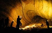
Kiev cave in Uzbekistan.
Visiting in Uzbekistan.
“Difficulties increase as you approach the goal. But let everyone make their way like the stars calmly, not in a hurry, but constantly striving for the intended goal”
Johann Goethe.
Speleotourism in Uzbekistan.
Kiev Cave (KILSI Cave - Kiev Laboratory of Speleological Research) is a karst cave with a depth of 990 meters. Located in the western part on the Kirktau plateau, the Zeravshan ridge (Uzbekistan, Samarkand region, Urgut district), 14 kilometers west of the city of Urgut, at an altitude of 2400 meters above sea level.
The cave belongs to the Gissar-Alai speleological region, Zeravshan-Gissar province in the karst erosion basin. The total length of the cave is 1850 meters, volume 36 000 cubic meters, depth up to 950 meters. It is a cascade of inclined slit-like limestone galleries and wells up to 90 meters deep.
Slow formations - stalactites, stalagmites, corallites and others. Air temperature about 5 ° C, water 3 ° C. In the cave there is a stream, the flow rate at the siphon is 15 liters per second in the low water and lake, up to 10 meters deep.
The entrance has the form of a narrow gap in the bottom of the karst funnel, at an altitude of 2398 meters above sea level. The mine was laid in massive dolomite Silurian limestones, broken by numerous faults into blocks in a large block block at the bottom of the karst funnel, in the southern part of the karst erosion basin Sarytkal, one kilometer west of Lake Katakul.
The basin is stretched from west to east, has a length of about 1.5 kilometers, a width of about 600 meters, and for the most part is the surface catchment of the mine. The Kirktau Plateau (Kirgtag - “Forty Mountains”) is replete with all kinds of caves with vertical karst cavities, grottoes, with underground labyrinths, karst springs and lakes.
A total of about sixty karst cavities were noted and studied. Kiev cave consists of alternating vertical shafts with a depth of 20 - 95 meters and inclined slit-shaped galleries with a length of 30 - 50 meters. It is laid according to the systems of cracks associated with two large faults with a strike of 50 - 230 ° and 130 - 310 °.
From a depth of 100 meters, a permanent watercourse begins, forming a chain of flowing lakes up to 1.7 meters deep. Water temperature is about 3 ° C. The mine ends in a siphon. Secondary formations are represented by allochthonous aquatic mechanical and residual sediments, as well as various aqueous chemogenic sediments (stalactites, stalagmites, sap barks, gurs, Zaberes, corallites, etc.).
Air temperature 4 - 5 ° С. The halls and threshold, which received the names: Hall Ukraine, Hall Zemlyanichka, Hall IV of the MMS Congress, the threshold of Unknown. Opened in 1972 by cavers of the Kiev section of speleotourism and the Laboratory of speleological research (supervisor A. B. Klimchuk).
In 1973, a depth of 520 meters was reached, in 1975 - 700 meters, in 1976 -1030 (?) Meters (Kiev and Tomsk speleologists, heads A. Klimchuk and V. Chuykov) and 1080 meters (?) (Crimean speleologists, head G. S. Pantyukhin).
Topographic survey was carried out by Kiev (leader V. Ya. Rogozhnikov) and Crimean (leader S. S. Evdokimov) cavers. In 1977, the All-Union Speleological Expedition (headed by V.V. Ilyukhin) re-shot the mine using a hydraulic level.
Its depth was 950 meters. Materials for description were provided by A.B.Klimchuk, G.S. Pantyukhin, V.V. Ilyukhin. In speleotourism, the Kiev cave is classified - 5 category of complexity.
Authority:
V.N.Dublyansky, V.V. Ilyukhin. The largest karst caves and mines of the USSR. M: Nauka, 1982, p. 46.
Photos
Alexander Petrov.