


![]()
Вы здесь
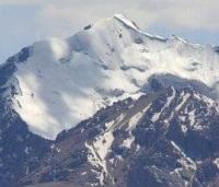
Glaciers of Ak-Shiyrak ridge.
Travel and tourism Kyrgyzstan mountains.
"Akshiyryak Glaciers. I have already said above that the Akshiyryak mountain system is quite capable of developing large glaciers. In almost all of its gorges, glaciers move, unloading it from the enormous amount of snow that accumulates on its upper basins and slopes."
A.V. Kaulbars. "Materials on the geography of Tien Shan collected during a journey in 1869."
Today traveling in Kyrgyzstan.
Ak-Shyirak ridge is second largest glaciated mountain range located between southern slopes of Terskey Ala-Too ridge and northern slopes of Kokshaal-Too ridge. In east, ridge borders on western slopes of Kuilyu-Too ridge. It is located in upper reaches of Taragai rivers in north, Irtash and Aktash in east, Karasai and Barlabas in south, in Jety-Oguz and Aksu districts of Issyk-Kul region.
The Ak-Shyyrak mountain range, this is one of the most compact nodes of the Tien-Shan glaciation, its degree of glaciation is 46%. The massif consists of three parallel ridges stretching from northwest to southeast. The highest point of the massif is 5125 m. a. s. l., another 4 peaks are more than 5000 m. a. s. l.
The interior of the massif has a typical alpine appearance with narrow rocky ridges that separate vast firn fields, often connected to each other through gentle passes. In the west, the massif rises 1000 - 1200 m. a. s. l. the high Arabel and Kumtor syrts, the northeastern slopes abruptly break off to the deep river valleys of the Sary-Jaz river basin.
The climate of Ak-Shyirak is harsh.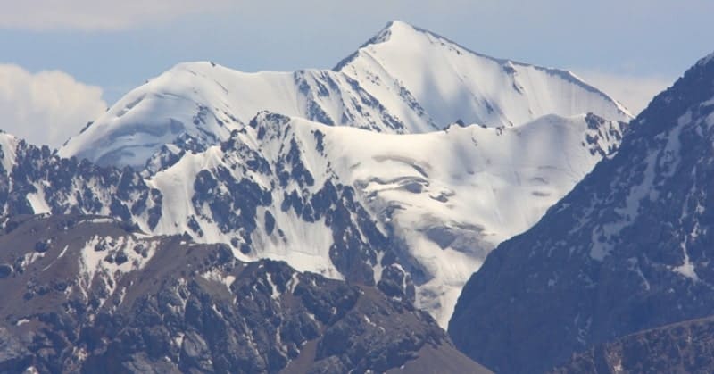
The average annual air temperature (-8.1 °) is the same as in the Arctic. Precipitation is brought mainly by westerly and northwesterly winds. The northwestern part of Ak-Shyirak is influenced by the Issyk-Kul basin, from where moist air masses penetrate the passes of the Terskey-Ala-Too ridge.
Here, up to 400 mm of precipitation falls annually. East of the massif, the amount of precipitation is about 200 mm. An important factor for the development of glaciation is the wind transfer of snow from the windward western slopes to the leeward eastern ones.
The snow border is the lowest located in the western part of the massif, with a height of 4100 - 4150 m. a. s. l.. To the southeast, it rises and reaches a maximum height on the glaciers of the southern border - 4500 - 4550 m. a. s. l. Glacier ablation is predominantly due to direct solar radiation. In total, there are 154 glaciers on the Ak-Shyirak massif with an area of 435.8 square kilometers.
18 glaciers over 5 square kilometers. Valley glaciers prevail (more than half the number and 89% of the total area). Complex valley glaciers occupying the longitudinal valleys between the ridges in the upper reaches are interconnected through passes and saddles.
The width of these glaciers is up to 2.5 kilometers, the thickness of the ice in the middle parts is about 200 meters. Valley glaciers have well-defined feeding areas, the even calm surface of the glacial ends is occasionally complicated by icefalls.
There are many glaciers of hanging valleys, especially in the eastern part of the massif. Hanging glaciers are found mainly in its marginal parts.
Glaciers of the western slope exist in the most favorable conditions - here, with a favorable exposure of the slope, more precipitation falls than in other parts of the massif. Valley glaciers with firn basins confined to wide gorges prevail.
The largest glacier on the Ak-Shyyrak massif is the complex Petrov valley glacier, 11.3 kilometers long, 69.8 square kilometers long, the glacier's feeding area lies in a deep longitudinal valley between the northern and middle Ak-Shyyrak ridges and connects with firn through several high saddles the Jaman-Su glacier basin in the northeast and with the North Kara-Sai glacier in the southwest.
Below the end of the glacier is a lake. In the mid-1950s, the lower 4.6 kilometers of the square lower part of the glacier consisted of dead ice with deep canyon-like channels of streams and an abundance of karst craters. However, on the 1957 AFS, traces of glacier activation were visible. Later, after a short revival, the glacial tongue was dead again.
Significant glaciation is the Kara-Sai River Valley, which penetrates deep into the massif. In the upper reaches of the valley are two large glaciers - Northern Kara-Sai with numerous tributaries and Southern Kara-Sai.
With a length of 12.2 kilometers, an area of 49.2 kilometers square, with its headwaters in the very center of the massif, is connected with the firn fields of the Petrov Glacier. At the beginning of the XXth century, the glacier advanced, leaving the final moraine and dam lake. In the late 50s. 
The surface of the tongue was covered with many hillocks with lakes. Such a relief is characteristic of inactive ice. But by 1958, the glacier advanced 920 - 1000 meters, forming a pressure moraine up to 40 - 45 meters high and about 150 meters wide.
The advance was apparently short-lived and occurred in 1955 - 1956. (Bondarev. 1963). Judging by the AFS of 1967, the glacier again began to retreat in 1973 (KS) retreat continued.
South Kara-Sai glacier.
Is currently catastrophically shrinking, its end part is thin dead ice, the melting of which is not compensated by the supply of matter from the feeding area, the ice thickness 2 kilometers from the end from 1943 to 1957 decreased by 36 meters.
The Jaman-Su glacier descends to the lowest altitude on Ak-Shyirak - 3545 m. a. s. l. The lower end of the glacier digs into erratic moraine deposits. From 1912 to 1959, the glacier retreated 1300 - 1350 meters. The retreat was accompanied by flattening of the surface and separation of tributaries.
Koyandy Glacier.
In the upper reaches of the river of the same name from 1933 to 1959 retreated to 640 - 720 meters, and at its end there was a glacial lake. The former tributary Veeroobraznyi glacier disconnected from the glacier, which in turn was divided into two glaciers.
In the northern part of the Ak-Shyyrak massif there are medium-sized valley glaciers (5 - 10 square kilometers. Small hanging glaciers are found on weakly dissected sections of the slopes. Two valley glaciers are Bezymyannyi, 4.9 km long, 5.9 km square and Chomoi, 5.1 kilometers.
An area of 11.2 kilometers square was tested by the first - between 1943 and 1967, the second - between 1943 and 1961. On the southern slope of the massif, small glaciers exist in unfavorable conditions due to southern exposure and low rainfall.
Here, the maximum height of the firn line for Ak-Shyirak is at an altitude of 4500 - 4550 m. a. s. l. and the ends of glaciers at an altitude of 4100 - 4300 m. a. s. l. (Avsyuk. 1952; Bondarev. 1963).
Total area of glaciation of Ak-Shiyrak ridge is about 430 square kilometers.
Largest glaciers of Ak-Shiyrak ridge.
Glacier Karasay Severny.
With a length of 12.2 kilometers, an area of 49.2 square kilometers, located at an altitude of 3800 to 4950 m. a. s. l.l, belongs to the Naryn river basin.
Jama-Suu Glacier.
With a length of 10.4 kilometers, an area of 35.0 square kilometers, located at an altitude of 3400 to 5040 m. a. s. l., belongs to the Sary-Jazz River Basin.
Koyandy Glacier (Koenduu).
With a length of 8.0 kilometers, an area of 24.3 square kilometers, located at an altitude of 3850 to 5000 m. a. s. l., belongs to the Ak-Shiyrak river basin.
Karasai Yuzhny Glacier.
With a length of 7.2 kilometers, an area of 16.0 square kilometers, is located at an altitude of 3880 to 4980 m. a. s. l., belongs to the Naryn river basin.
Davydov Glacier.
With a length of 5.8 kilometers, an area of 11.6 square kilometers, located at an altitude of 3720 to 4840 m. a. s. l.l, belongs to the Naryn river basin.
History of Davydov Glacier.
Davydov Glacier, located on the western slope of the Ak-Shyirak ridge, was named in 1925 after the head of the expedition of the Central Asian Meteorological Institute, Lev Konstantinovich Davydov (19.10.1893, Tashkent - 12.12.1968, Leningrad), a Soviet geographer and hydrologist, Doctor of Geographical Sciences (1947).
From 1930, he was the director of the Central Asian Hydrometeorological Institute.
Sarytor Glacier (Sary-Ter).
With a length of 5.5 kilometers, an area of 9.6 square kilometers, is located at an altitude of 3880 to 4460 m. a. s. l., belongs to the Sary-Jazz River Basin.
Bordo Yuzhny Glacier.
With a length of 5.1 kilometers, an area of 5.9 square kilometers, is located at an altitude of 3750 to 4770 m. a. s. l., belongs to the Naryn river basin.
4.5 km long Bordu Glacier.
An area of 7.9 square kilometers, is located at an altitude of 3730 to 4710 m. a. s. l., belongs to the Naryn River Basin.
Sarytor Glacier.
With a length of 5.5 kilometers, an area of 9.6 square kilometers, is located at an altitude of 3880 to 4460 m. a. s. l., belongs to the basin of the Sary-Jazz River.
5.1 km long Chomoi Glacier.
An area of 10.3 square kilometers, located at an altitude of 3600 to 5040 m. a. s. l., belongs to the Sary-Jazz River Basin.
Glacier Veeroobraznyi Left.
With a length of 5.1 kilometers, an area of 8.1 square kilometers, located at an altitude of 3880 to 4917 m. a. s. l., belongs to the Ak-Shiyrak river basin.
Glacier Veeroobraznyi Right.
5.1 km long, 7.3 square kilometers, located at an altitude of 3880 to 5100 m. a. s. l., belongs to the Ak-Shiyrak river basin.
Oroy Glacier.
With a length of 5.0 kilometers, an area of 8.6 square kilometers, is located at an altitude of 3860 to 5040 m. a. s. l., belongs to the Sary-Jazz River Basin.
Geographical coordinates of Akshiyrak ridge: N41°51'10 E78°17'12
Authority:
"Glaciers." L.D. Dolgushin, G.B. Osipova. Series "Nature of the world." Moscow, the publishing house "Thought". 1989.
Photos by:
Alexander Petrov.