


![]()
Вы здесь
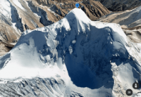
Peak of Soviet Constitution in ridge Kuilyu-Too.


Mountain ranges of Kyrgyzstan.
“... At the beginning of August 1936, after a tiring day's march, a group of climbers climbed the saddle that closed the B. Taldy-su glacier by evening. At the saddle, the whole group stopped, as if spellbound. In the rays of the evening sun, a beautiful, slender peak, bound by ice, sparkled in front of the climbers. As a pointed pyramid with a small shoulder, it towered over the glacier flowing to the south (Ayu-tor glacier). I was especially struck by its great relative height; it rose like a two-kilometer wall above the surface of the glacier. All the fatigue of the group members immediately disappeared, and for a long time they could not tear themselves away from the spectacle presented. It was decided to call the peak the peak of the Stalin Constitution, in honor of the historic act of 1936, the development and approval of the Constitution of the Soviet Union, the Basic Law of the country of victorious socialism.»
Letavet A.A. "Ten Journeys in the Mountains of Central Asia".
Highest peaks of Kyrgyzstan.
Peak of Soviet Constitution with a height of 5281 m. a. s. l. is located in southeastern part of Kuilu-Too ridge in Tien-Shan mountains in Jety-Oguz district of Issyk-Kul region.
From the Terekty River to the north, a powerful massif extends for 12 kilometers to the source of the Small Taldysu River, which belongs to the Sary-Dzhaz basin. In this massif, in its central part, there is the peak of the Soviet Constitution. The massif is enclosed between the sources of two rivers: Ayutor in the east, Ikichat in the west, both rivers belong to the Terekty basin.
From the north and northeast, the rock-ice walls of the Soviet Constitution fall sheer. From the northwestern slope of the summit descends the Ikichat Severny glacier with a length of 2.1 kilometers. On the western slope of the peak is the Ikichat Yuzhny glacier, 1.5 kilometers long.
5 kilometers from the peak of the Soviet Constitution to the east and a little to the north is the peak of Menzu with a height of 5068 meters above sea level. 17.3 kilometers west of the peak of the Soviet Constitution is the peak of Obruchev, 5203.2 meters above sea level.
First ascent to the peak of the Soviet Constitution.
1936
In the summer, the amateur group of A. Letavet set itself the task of crossing the Kuilyu-Too ridge several times in its eastern part and determining the nature and location of the main peaks. This task was completed. The gorges Big and Small Taldy-Su were passed and passes were found in the valley of the Terekty river.
1937
One of the tasks of the expedition was the first ascent to the peak of the Stalinist Constitution. After a fierce three-day struggle on September 7, 1937, an assault group consisting of I. Cherepov, V. Mukhin. II Popov and V. Ratseka reached the summit along the northern ridge in 2A category of difficulty.
The height of the peak turned out to be 5,250 m. a. s. l. To all those who observed the peak, both near and from afar, it seemed to be much higher, such an impression must be created due to its unusually slender shape and high relative height.
Geographical coordinates of peak of Soviet Constitution: N42°02'10 E78°54'23
Authority and photos:
Letavet A.A. "Ten Journeys in the Mountains of Central Asia". Geographgis, 1949.
Alexander Petrov.
Photos by:
Alexander Petrov.