


![]()
Вы здесь
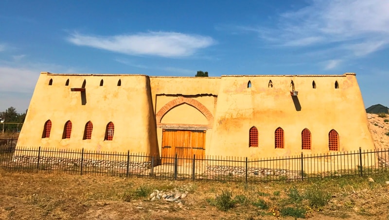
Ancient settlement of Talhir (Talgar).
Travel across Almaty.
“Caravans roam the Karatau mountains,
Camels on loaded caravans,
I didn’t know that the homeland is so hard to leave
Caravans flow down my dark tears”
The song "Elim-ah!" ("My native land...").
Tours of ancient cities in mountains of Zailiysky Alatau.
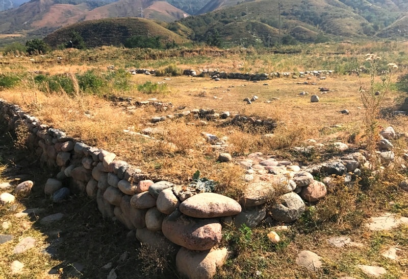
Ancient settlement of Talkhiz (Talgar, Talkhir) is located at an altitude of 1080 m. a. s. l., in southern part of city of Talgar, western part of settlement borders on right bank of Talgar River, on northern slope of Zailiyskiy Alatau ridge, in Talgar district, Almaty region.
The ancient town of Talhir (Talgar). Scroll to the top of the page of the geographical composition of the last third X century The Boundaries of the World, written in Persian. According to the outstanding orientalist V.V. Bartold, "an unknown author had much more thorough knowledge of the geography of Central Asia, especially its eastern parts, than his Arab contemporaries."
On one of the pages of this essay two villages are named - Tong and Talkhiza, located on the border between the possessions of the Djikil and Karluks, near Lake Issyk-Kul. Not without reason, the inhabitants of these villages must have earned a flattering characterization of warlike and courageous brave men.
Let's try to find these names on the map. Of particular interest is the village of Talhira (Talhiza). And above all, its sound similarities with the name of the city of Talgar, well known to contemporaries, located near Almaty. What do archaeological searches in the area mean?
The fact that there is a medieval settlement. It is located on the southern outskirts of the city of Talgar, on the banks of a turbulent and high-water river flowing in a deep picturesque canyon with steep steep slopes. The city itself is buried in apple trees
and pear orchards. The name Talgar also bears the mountain river that gave the city its name, and the highest peak of Zailiysky Alatau, the white mass of which is visible from afar, already 100 km to the north, from the ancient route of the Great Silk Road, and now the highway connecting Almaty with the north-eastern regions of Kazakhstan and By China.
The toponym (geographical name) Talgar, of course, is very ancient, it clearly distinguishes its second part “gar”, dating back to Indo-European languages and meaning “mountain”. Archaeologists found the remains of the ancient city on the southern outskirts of the city, on the right bank of the river of the same name when it exited the mountain gorge.
The monument has long attracted the attention of researchers. Famous archaeologists A.N. Bernshtam and A.Kh. Margulan was the first to determine that the annalistic Talhir and the settlement of Talgar are one and the same. For many years, excavations have been conducted at the ancient settlement, first by the expedition of the Kazakh pedagogical Institute (now Almaty State Pedagogical University named after Abay) under the direction of I.I. Kopylov, and in the second half of the 70s, the archaeological expedition of the Institute of Archeology.
A.H. Margulana, led by T.V. Savelyeva. Since 1994, American scientists, as well as researchers from Germany, Japan, Israel, not only archaeologists, but also ecologists, geomorphologists, soil scientists, paleobotanists, paleozoologists have been participating in the work.
This is understandable, since the study of the ancient city is a very difficult and responsible matter, and research should be comprehensive. How, for example, you can learn about the composition of the herd in the townspeople, studying only the bones of animals, found during excavations?
Paleozoologists do this. Without paleobotanists, it is impossible to determine what the inhabitants of the suburbs and nearby villages grew in their gardens and gardens. Specialists in earthquakes - paleoseismologists are also involved, since natural disasters have repeatedly violated the lives of citizens.
Traces of destruction from earthquakes were noted by them during the study of the monument. The result of many years of research in the Talgar settlement and, above all, excavations of its territory revealed a picture of the layout, lifestyle and occupation of residents.
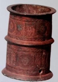
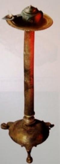
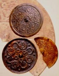
The nature of the urban dwelling and fortifications of the city, improvement and water supply. From the finds of the remains of handicraft workshops and of ceramics, iron, bronze, and glass products themselves, it became possible to determine the level of development of such crafts as pottery, blacksmithing, glass, copper, jewelry.
Talhira's international connections were clarified with Iran, China, Central Asia, India and even Japan in the X-XIII centuries. 1800 years ago, in the Bronze Age, areas of Talgar were already inhabited by people. They were engaged in agriculture and in domestic cattle breeding, smelted copper and made tools and weapons from bronze.
VIII-III century BC. here formed a union of Saka tribes, which in the IV century. BC. created their own state on the lands of Zhetysu. Later, in the III century. BC, it was replaced by the state of the ancient Usuns, which existed until the V century.
AD We know about the culture of Saks from the famous burial place of the “golden man” in Issyk barrow, and about the way of life of Saks and Usuns from excavations of their settlements near Talgar. It turned out that they were engaged in distant and nomadic cattle breeding, as well as growing several varieties of wheat, wheat, barley, and irrigated their crops with the help of branch channels.
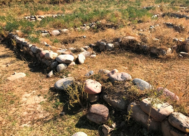
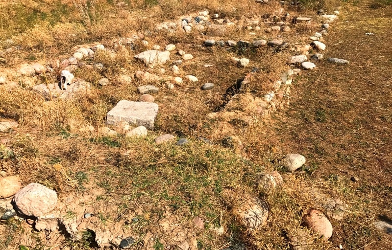
Talhir as a city appeared, apparently, on the site of one of such settlements in the VIII century. CE, and in the X-XII century. reached its peak. I managed to find out its layout. The town was divided by straight streets into quarters. Each quarter totaled from 12 to 14 manor houses, interconnected by small streets.
It is assumed that in the neighborhoods lived people connected by family ties. The manors of the city had a characteristic feature: the presence of a residential part, of the house and courtyard proper, the size of which depended on the wealth of the owner, since urban land always cost expensive.
Consider one of the estates. She's corner in the quarter. A careful study of the site plan makes it clear that the ancient builders each estate was divided into two parts: the smaller - the residential part of the house, and the larger - farm and livestock yards.
The entrances to each part of the house and to the farmyard were located on opposite sides. The entrance to the farmyard was on the south side and immediately led to the main street. It was convenient to drive cattle out to a watering place and grazing from here.
Two entrances to the residential part of the house were located on the western side and overlooked a narrow intra-quarter street. In the residential neighborhoods of Talhir, even during the harsh winter, there was no particular cold, because the wind, thanks to the narrow streets and dull walls of the houses, could not get inside the quarter.
The walls of the estate were built from local material: raw bricks and cobblestones. The lower part of the wall (foundation) was laid out of boulders and deepened into the ground to maintain heat in the winter season. The height of the masonry is approximately 1/3 of the entire height of the wall, which significantly increases the strength of the walls, and also protects the home from possible earthquakes.
The bonding material of the masonry is clay mortar. Raw clay bricks were also made from clay for the upper part of the walls. The internal walls of the house were made only of mud brick. As seismic belts in the masonry of the walls, logs of the Tyanshan spruce were used (its wood impregnated with resin does not rot).
The roof over the residential part of the house is gable. This is a prerequisite in foothill areas where there is a lot of rainfall. The walls were the main support of the ceiling. A semicircular recess was cut down in the upper part, or wooden "pillows" were placed on top of the wall.
Then the main longitudinal beam (matrix) is placed in a recess or on a “pillow” - a round log with a diameter of 14-20 cm. On average, the height of the room reached about 3 m. After fixing the matrix, poles with a diameter of 6 - 10 cm were placed perpendicularly to it, forming "Grating" of a gable floor.
On top of it lay a layer of reeds or reeds and branches, then a layer of dry grass, and on it a layer of clay mixed with ash. In this way, a flat roof, impervious to rain and snowmelt, was created. The slabs above the cattle pens were flat and light.
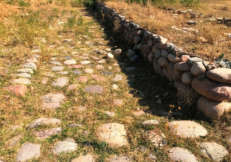
Most often they were covered only with dry grass, reeds or straw. Medieval Talhir had a high level of accomplishment. The main streets of the city were paved with cobblestone, water was supplied through clay pipes from the water supply system, sewage was discharged into water-absorbing wells.
It was home to artisans who made clay and copper utensils for sale, jewelry made of bronze, gold and silver, iron products: axes, knives, door locks, boilers, tips of arable tools, carpentry tools. The bone-carving craft achieved high perfection, and the masters from Talhir used horns and bones of both wild animals - deer, argali, saiga, and livestock - sheep, horses, cows, as material.
We can now judge all this based on materials from archaeological research. An important role in the life of the city was played by international trade along the Great Silk Road. Talhir occupied a nodal position on it, since here. The Silk Road branched: one direction went northeast down the Talgar River to the river Ili, and then to Prijungar, to the banks of Alakol and further to China, and the second went east through Chilik to Charyn, and then along the right bank of the river Ili through modern Dzharkent and Khorgos to China or through Chilik, modern Raimbek (Narynkol) also to China.
Merchants from different countries had their caravanserais in Talhir, where they rested and then continued on. They sold part of the overseas goods at the city bazaar, or paid for goods with Talkhir "customs officers" and presented strange things to the rulers of the city.
During the excavations of the houses of the townspeople, bronze mirrors, china from China, bronze jugs and dishes from Iran, ivory products brought from distant India, pottery from Samarkand, even from distant Japan, Talhir got a faience dish. It depicts people in rich gilded robes.
The list of UNESCO included the ancient settlement Talhis Talgar district, Almaty region).
Geographic coordinates of ancient settlement of Talkhiz (Talgar): N43°16'45 E77°13'20
Authority:
"The medieval cities of Kazakhstan on the Great Silk Road." K.M. Baipakov, Almaty, Gylym, 1998, 216 p.
Photos by:
Alexander Petrov.