


![]()
Вы здесь
Kokaral dam.
Visit to Northern Aral in Kazakhstan.
“Everything in excess is opposed to nature”
Hippocrates.
Excursion to Kok-Aral dam.
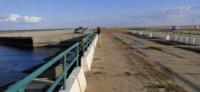
Kokaral dam - a dam that straps the Berg's Strait between the North Aral Sea (Malaya Sea) and the Southern Aral Sea (Big Sea) is located at an altitude of 45 meters above sea level, is located 1.5 kilometers south of the Syr Darya delta, 23.2 kilometers at 23.2 kilometers to the north-west of the Aklak hydroelectric power engine, 104 kilometers southwest of Aralsk, 25 kilometers north-west of the village of Karateren, southeast of the former Kokaral Peninsula, in the Aral district of the Kyzylorda region.
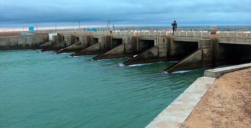
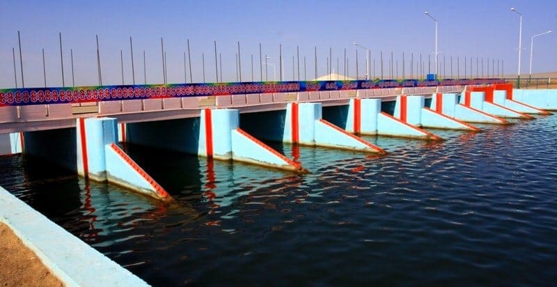
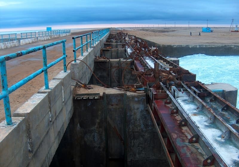
The name of the dam comes from the former peninsula of the Kokaral which now has become a plot of land. Within the framework of the project “Regulation of the River of the Syrdarya and the North Aral Sea” (RRSSAM) in 2003 - 2005, Kazakhstan built a cocaraal from the peninsula and almost to the mouth of the Syrdarya Kokaral Dam with a hydraulic shutter (which allows you to skip excess water to regulate the level of a reservoir), which fenced off a small Aral from the rest (large aral).
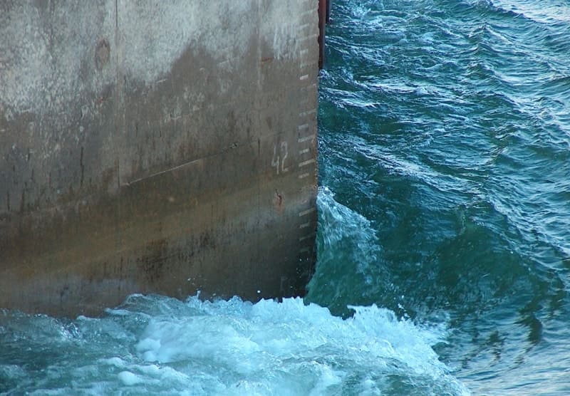
hanks to this, the stock of the Syrdarya accumulates in the small Aral, the water level here has increased to 42 meters of absolute height, the salinity decreased, which allows you to breed some fishing fish. In 2007, the catch of fish in Small Aral amounted to 1910 tons, of which Kambala accounted for 640 tons, the rest - freshwater species (carp, asp, pike perch, bream, som).
This building is one of the main points in the project “Regulation of the River of the Syrdarya and the preservation of the northern part of the Aral Sea”. The total cost is more than 85,000,000 dollars. The World Bank was allocated as a loan, the republic’s budget - about 22,000,000.
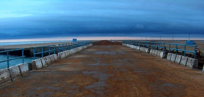
They began to build a new dam in 2004 - with the involvement of Russian engineers and the money of the International Bank for Reconstruction and Development. The Kokaral dam is four meters high and thirteen kilometers -length divided the sea into two arals through the Berg's Strait, through which water previously flowed into the southern sea.
The width of the dam at the base is 300, and at the top - nine meters. Three million cubic meters of sand and crushed stone are laid in the body of the dam. For critical cases, spilling - several cylindrical holes with a bandwidth of 46 cubic meters per second.
In only a year, the level of small aral rose by four meters. Now water is at a mark of 42 meters above the ocean: this is 14 meters higher than in South Aral, but 11 meters below forty years ago. According to experts, the implementation of the project will help to significantly improve the environmental situation of the Aral region.
This project includes not only the dam, but also the Aklak hydroelectric station, the head structures on the Sagimbai and Domalak channels, the ATEK structures, the protective dams on the Syr Darya, and the hiding of its channel.
In the late eighties, the northern part of the sea finally separated from the southern. Syrdarya water, according to the remaining narrow breakthrough, proceeded from the small part of the sea. Small Aral Challenge and disappeared before our eyes.
The construction of structures of the Kokaral dam and the hydraulic complex "Aklak" led the Russian OJSC Zarubezhvodstroy. He led the project-the Committee on Water Resources of the Ministry of Agriculture of the Republic, and technical supervision was carried out by the British-Turkish company Mott-Makdonald.
In the Small Aral, 29 cubo -kilometers of water were accumulated, in comparison - this is six times more than in the Shardarinsky reservoir. Water covered the dry bottom of the sea. This made it possible to restore the fish reserves of the region.
The environmental situation around the North Aral Sea has improved. Life reappeared on deserted and deserted lands. It is assumed that by 2012 the catch of fish in the small Aral will reach 10,000 tons (in the 1980s, about 60,000 tons were caught in the entire Aral Sea).
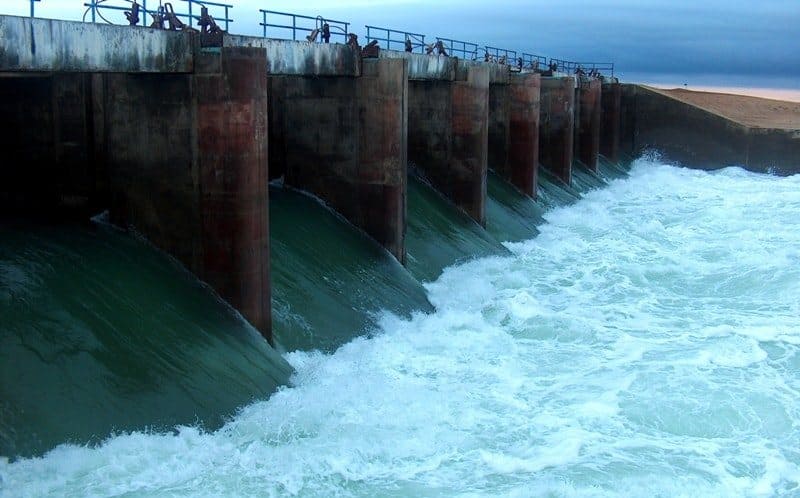
On the dam, a culvert was built with a bandwidth of 600 meters of cubic per second, designed to protect it from destruction by discharge of excess water into the Southern Aral. It is assumed that water will be covered with an area of 870 square kilometers, and this will restore the flora and fauna of the Aral Sea region.
In Aralsk, the Fisheries-Perepretting Combam Balyk fishing plant (300 tons per year), located on the site of the former bakery, is currently functioning. As part of the implementation of the second phase of the PRSSAM project in 2010 - 2015, it is planned to build a dam with a hydroelectric complex in the northern part of the Small Aral, separate the Sary -Shyganak bay and fill it with water along a specially dug canal from the mouth of the Syrdarya, bringing the water level in it to 46 meters.
It is supposed to build a navigable channel to the port of Aralsk (the width of the canal along the bottom will be 100 meters, a length of 23 kilometers). To ensure transport communications between Aralsk and a complex of structures in the Sary-Shyganak Gulf, the project provides for the construction of a highway of V category with a length of about 50 kilometers and a width of 8 meters parallel to the former coastline of the Aral Sea.
The project of the second phase of the revival of the North Aral Sea is being prepared. At the rate of 250 - 300 million dollars, it is planned to reconstruct the system of reservoirs with the flow of the Syr Darya in Kazakhstan, clean the riverbed and build another more powerful dam with the gateway at the entrance to the Sary -Shyganak bay, on which Aralsk stands.
The water of the Syr Darya should fill the bay through a 50-meter canal-it will be sprouted from the Delta Lake Kamihubas to the port of Aralsk.
Geographic coordinates of Kokaral dam: N46 ° 06'07.54 "E60 ° 46'09.51"

Authority:
Mass media of Kazakhstan. http://www.inform.kz
Photo by
Alexander Petrov.