


![]()
Вы здесь
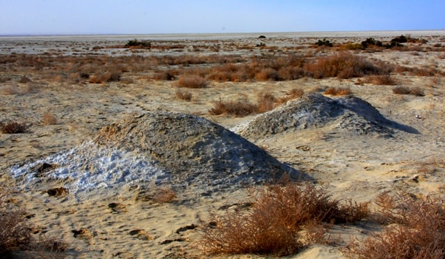
History of Aral Sea


Walking tour to Aral Sea.
“The Aral Sea is a gloomy sea. Flat shores, wormwood, sands, erratic mountains along them. The islands on the Aral Sea are pancakes, poured onto a frying pan, flat to a gloss, spread flat on the water - you can see the shore, and there is no life on them. Neither birds, nor cereals, but the human spirit is only felt in the summer. The main island in the Aral Sea is Barca Kelmes. What it means is unknown, but the Kyrgyz say that "human death". In the summer from the Aral village go to the island of fishing. Rich fishing at Bars-Kelmes, boiling water from the fish course. But, as autumn seamen roar with foamy bunnies, fishing is saved in a quiet bay of the Aral village and they don’t show their nose until spring. If all the catch from the island is not brought to the seas, the fish remains to winter in salted wooden stacked sheds. In severe winters, when the sea freezes from the Chernyshev Bay to Bars itself, expanse to the chasers. They run across the ice to the island, salty barbel or carp are drunk to the point that, on the spot, they die. And then, having returned in the spring, when he breaks the ice crust of Syr Darya with yellow clay of flood, they find nothing fishing from the pickle thrown in the fall. The seamen roar, roam the sea from November to February. And the rest of the time only occasionally storms fly in, and in the summer the Aral stands motionless - a precious mirror. Boring Sea Aral. Aral’s joy is blue-color, extraordinary.”
Lavrenev Boris Andreevich “Forty-first”.
Bird Watching Tours Aral Sea Kazakhstan.
History of Aral Sea is a history of changes. Water level of Aral Sea has been changing at different times. The sea was filled with Syrdarya river water, later it was fed by Amudarya river water. Amudarya River’s bed has been changing for a very long period of time.
In the early XXth century as a result of wet climate and increase of water volume in Amudarya River water level rose to 58 - 60 meters. Later climate became drier after what water lever first decreased to 35 meters and to 27 meters after.
There have been three periods of drying of Aral sea, but later there also have been periods of high water in the sea.
The ancient history of the Aral Sea, knew the periods of falling and rising levels. Now this story is quite reliably reconstructed by various methods. The specialists have disagreements in some details and dates, but, in general terms, the evolution of the Aral Sea looks something like this.
Initially, the basin of the Aral Sea was fed only by the waters of the Syr Darya, which formed a small lake in it. At that time, the Amu Darya flowed into the Caspian Sea (its ancient dry channel towards the Caspian, called Uzba, is well preserved to this day).
Then, according to various researchers, from 10 to 25 thousand years ago, the channel of the Amu Darya changed, and it went to the Aral. The reason for this was tectonic movements of the Earth's surface. The fact is that the features of the relief in the area of the watershed between the Caspian and the Aral Sea are such that a very slight tectonic uplift is enough to redirect the river from one reservoir to another.
As a result of the influx of water from the Amu Darya, the Aral Sea level rose to about the level we were used to at the beginning of the XXth century (53 m. a. s. l.). Then, from 4 to 8 thousand years ago, the climate humidified, and the river flow into the Aral Sea almost tripled.
As a result, the level rose to record levels of 58 - 60 meters, and the Aral Sea through the Sarakamysh Depression again "flowed" into Uzboy and connected through it with the Caspian. After some time, a new era of climate aridization followed, and more than three thousand years ago, the Aral Sea level again fell to 35 meters (communication with the Caspian was interrupted again), and then rose to 45 - 55 meters and fluctuated between these marks, until 1500 - 1900 years ago, a new regression (drying out) did not occur - so far the deepest in history.
At this time, the level dropped to the level of 27 meters, that is, even lower than now. Later, the level gradually rose again, and 400 - 600 years ago a new, so-called medieval regression took place, when the Aral surface was at 31 meters above sea level, which roughly corresponds to the recent situation in the early 2000s.
This medieval regression is confirmed not only by geological data, but also by archaeological finds and even chronicles. In the ancient history of the Aral Sea there were already at least three episodes of drying, comparable to the current one.
And each time they were replaced by periods of full-flowing sea.
The history of the Aral Sea is contradictory and unclear, despite the fact that many tomes have been devoted to its research, beginning from the beginning of the last millennium, and from the second half of the XIXth century, the Aral became the object of numerous expeditions and works of the Russian Geographical Society and various scientific organizations of the Russian state.
The results of these works were summarized in 1908 by L. Berg in his famous work, "An Essay on the History of Research of the Aral Sea," where he states that none of the Greek and Roman authors had a direct or indirect mention of the Aral Sea, but many of they are talking about Oksa (Amu Darya) and Aksart (Syrdarya), it is not clear where they flowed.
According to the testimony of the famous Khorezm scholar Al Beruni, who died in 1048, the Khorezmians, dating from 1292 BC, testify to the existence of the Aral Sea. Berg makes the same reference to the holy book of the Avesta, where there is an indication that the Vakhsh river or the current Amu Darya flows into Lake Varakhsha, by which some mean the Aral Sea.
The first more or less reliable sources about the existence of the Aral Sea belong to the Arabic scripts that depict the evidence of the conquerors of Khorezm in 712. These data are described in detail by V.V. Barthold of which means that already in the 800s the Aral Sea existed, and it was located near Khorezm, because its description completely coincides with the character of the eastern coast of the Aral Sea.
Other evidence belongs to Massudi ibn Nurusti, Al Balkhi and a number of other Arab writers and geographic researchers. Geological surveys, which were carried out at the end of the 19th and the beginning of the 20th centuries (A.M. Konshin, P.M. Lessor, V. Obruchev), boiled down to the fact that in the post-Pleocene era a part of the Karakum desert between the Ustyurt patch in the north , by the mouths of Murghab and Tejen in the south, in the west, the soles of Kopetdag were flooded by the Great Aral.
The eastern half of the connected Aral-Caspian Sea, in their opinion, had the Unguz coastline as the border of the former Karakum Gulf. This united sea covered a wide strip of the modern Caspian Sea right up to the base of the western spurs of the Kopetdag and connected with the Karakum and Chilmetkum bays along two straits - the Big and Small Balkh.
The Aral part in the same period flooded the entire Sarykamysh depression and formed a gulf before Pitnyak, now occupied by the modern Amu Darya delta and the Khiva oasis (by the way, this explains the sedimentary deposits at Pitnyak).
Uzboy was a strait connecting both of these water areas, but, obviously, its current form with large deviations formed as the Caspian separated from the Aral Sea and the difference in elevations between them increased.
During the subsequent geological period to our days, the united Aral-Caspian basin was divided into its component parts and its gradual reduction to its current limits. First, a watershed appeared between the Aral-Sarykamysh and the Caspian at Ball Ishem in Ustyurt, then the Uzboy channel gradually became apparent.
The sequence of drying is confirmed by examples of transitional deposits from fresh cemeteries of the Caspian mollusks (along Uzboy, in the sands of Chilmetkul, along the southeastern coast of the Caspian), covered with bare loose sand with weak and young vegetation, to ancient formations in central Karakum that transformed into shores, takyrs compacted sand mounds fixed by woody vegetation.
Shores, as the lowest points of the seabed, nourished by pressure bitter-saline solutions, preserved the appearance of ancient coastal lakes. All researchers and historians from ancient times describe the transformation of the Aral Sea and the Caspian depending on the water content of the rivers of their joint basin and the development of irrigation.
They state the fact of the final drying of Sarykamysh from the end of the XVIth century, when the Amu Darya no longer broke into Sarykamysh along Kunya - Daria and Daudan and further along Uzboy. The Uzboy from the Caspian to the Balla Item watershed has a rise of 40 meters over a length of more than 200 km.
According to Obruchev, the existence of Sarykamysh took place from the 7th century until the XIIth century until the 16th century. Jenkinson in 1559 on the road to Khiva noted the presence of Sarykamysh, which he mistook for the flow of Oxus into the Caspian.
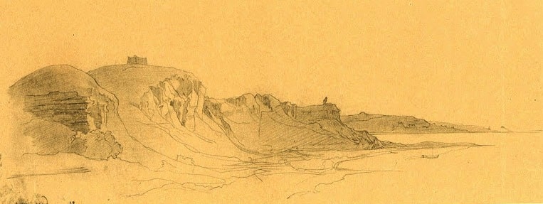
He relies on the similar evidence of Abdulgazi Khan, Gamdudla and other Khorezm chroniclers. The Aral-Caspian lowland is depicted on more than a dozen maps, carefully analyzed by Rene Letal and Monica Mainglo in their beautiful monograph Aral - Aral (Springler - Verlag France, Paris, 1993).
Starting from the “Geography” of Ptolemy (II century BC), in which the Caspian is in all its grandeur, but there is no mention of the Aral Sea (Fig. 1), through the scheme of Al Idrisi (1132) - where the Aral Sea is through the “Catalan Atlas” (1352) to the map of Butakov, where the Aral is already shown in a familiar form to us, we can trace all the migration dynamics of the Aral Sea in human perception.
Most researchers (B.V. Andrianov, A.S. Kes, P.V. Fedorov, V.A. Fedorovich, E.G. Maev, I.V. Rubanov, A.L. Yanshin and others) are based on geological and historical surveys came to almost a single conclusion, well formulated by N.V. Aladin: "in prehistoric times, changes in the level and salinity of the Aral Sea took place due to changes in the natural climate."
During the humid climatic phase, the Syr Darya and Amu Darya were full of water, and the lake reached a maximum level of 72 - 73 m. In contrast, during the phases of the arid climate, both rivers became shallow, the Aral level also fell and the salinity of the Aral Sea increased.
In historical time since the existence of ancient Khorezm, level changes depended, to some extent, on climate change, but mainly on irrigation activities in the region along both rivers. During periods of intensive development of the countries adjacent to the Aral Sea, an increase in land irrigation led to the withdrawal of most of the water for this purpose, and the water level in the Aral Sea immediately declined.
During unfavorable periods in the region (wars, revolutions, etc.), irrigated lands were reduced, and the rivers and the Aral were again filled with water. Geological and hydrological surveys conducted by A.S. Kesya and a number of prominent geographers in the 80s of the last century showed that the Amu Darya and Syr Darya, constantly changing their routes and migrating through the Middle a significant amount of desert, finely dusty, sandy-sandy deposits that created the delta and most of the channel and channels of the Amu Darya.
On the other hand, as the studies of zoologists, in particular, Polishchuk, Aladin from the Zoological Institute of the USSR Academy of Sciences in 1990, show, the Aral Sea itself is distinguished by a very poor initial fauna, there are no many groups of animals that are developed in the Caspian Sea, which is close in origin.
At the same time, distinctive species are found in the Aral Sea, and all this indicates that the salinization, which periodically occurred with the Aral Sea, was reflected in these huge transformations. The analysis carried out by zoologists showed that in the Aral Sea there were mainly preserved a small number of marine oceanic species, and a huge complex of brackish-water groups, up to the Caspian-estuary fauna, was destroyed here.
All rivers flowing into the Aral Sea have not preserved marine types of fish, or at least some remnant of this fauna. This indicates that the waters of the Amu Darya and other rivers penetrated in one way or another both into the Aral Basin and through the lower Uzboy valley and fell into the Caspian Sea.
At the same time, it is worth noting the very developed deltas of both the Syr Darya and the Amu Darya, which totaled quite significant areas. According to N.M. Novikova, during a steady influx of about 41 km3 of water into the Amu Darya delta, the total area of land flooded by floods exceeded 3800 sq. km, the area of the lakes was 820 km2.
The Syr Darya delta has also received significant development. At the same time, intense vegetative background was widespread in the local deltas. Periodically flooded deltas were characterized by huge areas of fruiting reeds, tugai, hayfields and pastures.
In particular, until 1970 the area of reed thickets amounted to 700 thousand ha, tugai - 1.3 million ha, hayfields - 420 thousand ha, pastures - 728 thousand ha only in the Amu Darya delta. The corresponding areas were occupied by delta and other vegetation in the Syrdarya delta. A.S. gives a different picture.
Agreeing with several periods of flooding of the Aral basin from the Late Pliocene, first with the waters of the Akchagyl and then the Absheron Sea, she does not consider the existence of a single Aral-Caspian Sea to be proven and insists on the absence of a connection between the Aral and Caspian Sea, although she maintains the opinion that the highest elevations of the early Absheron Lake belong to 80th, by the end of the Absheron, dropping to zero.
The Akchagyl period was marked, in her opinion, by the partial existence of the Aral Sea below the modern one (near or below 40 m). In the Neolithic period, the Amu Darya, filling the Khorezm Depression with alluvium, broke through into Sarykamysh and created an extensive lake here and in Assak-Audan, from which water in the amount of about 20% of its flow (this was determined by the hydraulic parameters of Uzboy) flowed through Uzboy to the Caspian Sea.
This runoff lasted for the 3rd-4th millennium BC. and periodically in the second - beginning of the first millennium BC The Syr Darya at that time flowed into the Aral Sea. Although A.L. Yanshin argued for the presence of transgression during this period, but subsequent research by Kiryukhin L.G., Kravchuk and Fedorov P.V. (1966) rejected this as well as later studies of E.G. Maeva, Yu.A. Kornicheva (1999), and before that I.V. Rubanova (1982).
It is more or less clear now that the Aral Sea has undergone five or seven (according to recent radiocarbon studies of bottom sediments) transgressions, the most powerful of which belong to the highest terraces, apparently related to the Early Pliocene (A.V. Shitikov) or Akchagyl.
The source of such a high water cut is not clear - these are the results of the melting of the northern ice masses, as suggested in his work "Patterns of salt accumulation in the Aral-Caspian lowland," USSR Academy of Sciences, 1956, V.A. Kovda and V.V. Egorov, or the inflow of the waters of the Praamudarya, which is mentioned in the Avesta (presumably, this is the river that combined the waters of all the tributaries of the Amu Darya, including not only Zeravshan, Tejen, Murghab, but also Syr Darya and Chu before the overlap of the Isthmus of Buram.
Kes, the results of research by PI Chalov et al. (1966). The first stage of flooding of the Aral Basin began in the Late Pliocene, at which time the western plains of Central Asia were flooded by the waters of the vast Akchagyl and then Absheron Sea but the fauna, terraces, and coastal ramparts of this age are found in Sarykamysh and Assak-Audan, in the Aral Sea and in some depressions of the Kyzylkum. advancing into the Aral depression and along with the Syr Darya, which then flowed through the Gendar and Kuvandarya, began to fill it and formed the modern sea.
At the beginning of the 19th century, the level of the Aral Sea was low. In 1845 and after the 1860s, some increases were noted. In the early 80s, the level became especially low, and therefore researchers of those times came.
The amplitude of oscillations during the half-century of the late XIX and early XX centuries was not more than three meters.
The natural water resources of the Amu Darya (without drainage areas of Tedzhen, Murgab, etc.) amount to 75 km / year and Syrdarya 37 km / year (total 112 km / year) in the formation zone. Fluctuations in the annual values of the natural water resources of the Amu Darya and Syr Darya are quite significant (Сv variation coefficients are 0.15 and 0.21, respectively) and are characterized by significant synchronism (correlation coefficient 0.83), which makes it difficult to provide water to the main consumers of river flow in dry years.
The basins of the Amu Darya and Syr Darya are areas of ancient irrigation that change the natural flow of these rivers for a long time. Prior to the beginning of the 1950s, the volumes of irrevocable withdrawal of runoff fluctuated insignificantly both in individual river basins and in the sea basin as a whole and reached 29-33 km3 / year.
The increase in water withdrawals from rivers in the 1950s to 35 - 42 km3 / year, due to the expansion of irrigated agriculture and water management measures (construction of reservoirs on the Syr Darya, the supply of Amu Darya water to the Karakum canal), was compensated by a slight decrease in channel runoff losses, and also the natural high water availability of this decade (total natural water resources were approximately 9% higher than normal).
As a result, until the beginning of the 60s, the inflow of river waters to the sea and its regime remained relatively stable. The time period from the beginning of systematic instrumental observations of the level and other characteristics of the sea regime (1911) to the 60s can be defined as conditionally natural.
The approximate equality of the input and expenditure components of the water balance of the sea (table) determined insignificant fluctuations of the level around the level of 53 m abs., Which was taken as the average multi-year level. The average area of the water mirror at 53 m. Abs.
It amounted to 66.1 thousand km2, and the water volume reached 1064 km3. By its size, the Aral Sea ranked fourth in the row of lakes in the world: after the Caspian, the Upper Lakes of North America and Lake. Chad. The area of the Aral Sea was 64,490 km2. (with islands); the greatest length is 428 km, the greatest width is 284 km.
The lake was relatively shallow: the greatest depth - 68 meters; the average depth is only 16 meters. The greatest depths are concentrated near the western coast in the form of a narrow strip; an area deeper than 30 meters occupied only about 4% of the lake.
So, the ancient Aral Sea, which underwent 5 or 6 transgressions - increase and subsequent drying up - again found itself on the verge of a new drying out. Degradation of the sea and the Aral Sea region. Although the disappearance of the Aral Sea is attributed to the Soviet state as the main culprit of this natural and man-made disaster, the idea of sacrificing the Aral Sea to the development of irrigation and the growth of agricultural production belongs to pre-revolutionary scientists.
In particular, A.I. Voeikov (1908) insisted that the existence of the Aral Sea in the rational management of the economy is absolutely unjustified, since the economic effect of it (fish farming, sea transport) is much less than the effect of economic development and especially irrigated agriculture.
In 1913, the same idea was presented not by a scientist, but by Prince V.I. Masalsky, who believes that the ultimate goal is "to use all the water resources of the region and create a new Turkestan ... by introducing tens of millions of hectares of new lands to the culture and providing Russian industry with the necessary cotton ...".
The development of irrigation begun by the Russian government received an unprecedented acceleration in Soviet times. But until 1960, water withdrawal for irrigation was accompanied by an increase in collector networks and, accordingly, an increase in return water, as a result of which there were no significant changes in river deltas and in the sea.
For 1911 - 1960 a quasi-equilibrium state of the salt balance of the sea is characteristic. Each year, 25.5 million tons of salts entered the sea, the bulk of which was sedimented by mixing sea and river waters (due to the oversaturation of Aral waters with calcium carbonate) and precipitated in shallow waters, in bays, bays and filtration lakes of the northern, eastern and southern coasts of the sea.
Due to the freezing of the sea and thawing, the average salinity of the sea during this period varied in the range of 9.6 - 10.3%. The relatively large annual volume of river runoff (about 1/19 of the volume of the sea) determined the very peculiar salt composition of the Aral waters, which differs from the salt composition of other inland and semi-enclosed seas by a high content of carbonate and sulfate salts.
The modern period in the life of the sea, starting in 1961, can be described as a period of active anthropogenic influence on its regime. A sharp increase in irrevocable flow withdrawals, reaching in recent years 70 – 75 km3 / year, exhaustion of the compensatory capabilities of rivers, as well as natural low water availability for two decades from 1960-1980. (92%) led to a violation of equal.

Authority:
wikivisually.com
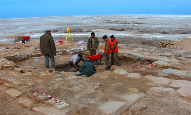
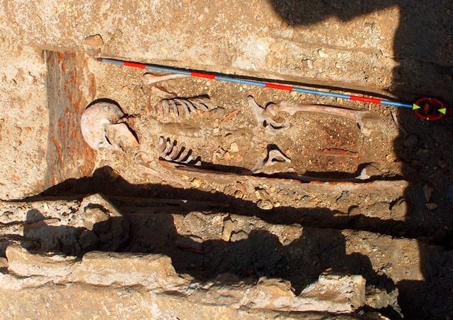
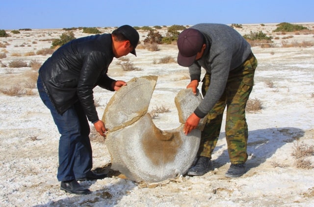
Photos by:
Alexander Petrov.