


![]()
Вы здесь
Sagyz Nature Reserve.
Botanical tours of Central Asia.
“The joy of seeing and understanding is the most beautiful gift of nature”
A. Einstein.
Kazakhstan tulips.
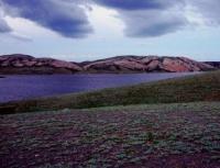
State integrated nature reserve "Sagyz" is located in the Baiganinsky district of Aktobe region. The motivation for organizing the Big Barsuki integrated nature reserve was the conservation of ecosystems of the sand massif and river valleys with habitats of rare, endemic and relict species of flora and fauna.
Places of nesting and resting on the passage of waterfowl and near-water birds, a promising key ornithological territory. The relief of a flat or weakly wavy plain with absolute elevations of 200 m, rugged by valleys of temporary streams.
On the right bank of the river. Sagyz is located the sandy mass “Akkumsagyz sands”, elongated by a narrow strip along the river. The relief is hilly-ridged, flat with channel-shaped hollows and the remains of river banks. Aeolian sediments are represented by fine, less often medium-grained sands.
Sagyza Valley - a wide floodplain (from 1 to 4 km), open, sometimes overgrown with reeds and waterlogged, cut by channels, drying out riverbeds, ravines; gentle shores, steep in places (up to 7 m). The climate is desert, sharply continental, characterized by high summer temperatures - the average July temperature is + 25 + 26 ° C and moderately cold, very little snowy winter -13 ° C.
The average annual air temperature is + 6.9 ° C; the sum of temperatures above 10 ° C is 3200 - 3500 °. The average annual rainfall is 120 - 140 mm, the hydrothermal coefficient is 0.3 - 0.4. The average annual wind speed is from 4 - 4.5 to 4.5 - 5.5 m / s, eastern and northern winds prevail during the year.
Surface water is represented by the Sagyz River, which is formed from the confluence of the Kyzyladylsai and Daulda rivers, has a constant watercourse and is lost 10-12 km south of the station. Makat in the suns of Tedyaksor.
The total length of the river is 510 km, the catchment area is 19.4 thousand square kilometers. The water is salty. The width of the river is from 3 to 48 m, the depth is from 0.3 to 2.0 m, the flow velocity is 0.1 m / s. The waters are highly mineralized, especially in the low-water period - in the flood of 0.8 - 0.9 g / l, in the low-water period it can reach 20 g / l.
The river freezes at the end of November, opens at the end of March, the thickness of the ice can reach 1.0 m. Spring flood in early April and lasts 15 - 20 days; low water in early June. In the dry years there is no constant flow, Sagyz breaks up into separate reaches.
The underground waters of the territory lie at a depth of 1 – 4 m in the north, to 4 – 20 m in the southern part of the sands. Along the loamy margins of the sands are 15 – 20 m, and by depressions - 1 – 4 m. The water bearing sediments are represented by fine- and medium-grained sands with a thickness of 3 to 30 m, in the thickness of which groundwater lies at a depth of 0.5 - 1 m in depressions up to 10 - 15 m under the hillocks.
Fresh water with a salinity of up to 1 g / l of calcium and sodium bicarbonate is widespread in the zone of intense water exchange. In the fixed sands, it increases to 1 - 3 / l, the composition is sulfate-carbonate or sodium sulfate.
On the outskirts of the sand mineralization reaches 5 - 10 g / l, sometimes more. Groundwater in the floodplain of the Sagyz River and on the lower terrace lies at a depth of 0.5 - 5 m, at high to 15 - 20 m. In the Sagyz valley, increased salinity is noted - up to 15 g / l.
Nutrition due to flood filtration, to a lesser extent due to atmospheric precipitation filtration. The soil cover is represented by light chestnut solonetzic soils in combination with desert solonetzic, brown desert solonetzic soils and tuberous ridges semi-fixed and loose sand.
The hilly semi-fixed sands are fine-grained, loose, little affected by the soil-forming process. As the sand overgrows, desert sandy soils form on them. In the moist between ridge basins meadow-alluvial soils are developed.
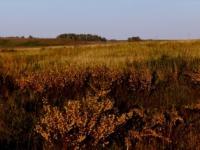
The vegetation cover is wormwood and feather grass, represented by complexes of desert shrubs.
Authority:
Natural resources of Aktobe region. Ecoproject LLP. 216 p.
Photos
Alexander Petrov.