


![]()
Вы здесь
Tortkuli Lesser Hobda.
Nature sighte Tours in Aktobe region.
"How can only see an eye,
A boundless front is floating in the clouds
The cloud cried a little
And, like everyone else, it went beyond the horizon”
Anatoly Bolutenko.
Sights of Aktobe region.
On the relatively calm surface of the Podural Plateau, in many places, the cone-shaped remnants of paleogene sands and sandstones, lying on the strata of brown-green clays, are sharply distinguished. Such remnants, covered from above with a cap of dense glandular sandstones, received the local name tortkuli.
The northernmost cake-kul Poduralya rises in the upper reaches of the Small Khobda river in the south of Akbulaksky district. The area here has soft, rounded shapes. Chains of ridges scatter across the boundless steppe breadth of the Ileksko-Khobdinsky interfluve.
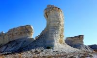
Between the gorges green hollows wind with thickets of wild cherries, bobbins, and chiligos. They are going to a flat-bottomed beam Sarybulak. At the top of the beam, the steppe is flattened and looks like a huge amphitheater, on which stands the unusual mountain-cone Korsak-Bas, which in Kazakh means “the head of a fox.
The height of the mountain is 310 meters above sea level, and it rises almost 50 meters above its sole. The remnant is composed of dense glandular sandstones with interbeds of clay, sand and gravel. These rocks formed in the Paleogene, more than 40 million years ago.
Thanks to its glandular cap, the mountain was preserved from destruction and erosion. The slopes of the mountain are very steep, and even steep from the southern and eastern sides. Wild pigeons, small falcons, and other small birds arrange nests in the steep walls.
On plates of sandstones one can find imprints of fossil marine plants - witnesses of a distant geological era. Climbing the mountain is very steep, a strong gusty wind is ready to rip the rising traveler from the slope.
A panorama of the steppe expanses opens from the top: in the north there is a juicy green ribbon of the Ilek valley, in the east and west - endless ridges, in the south - not equal hills, steeply terminating towards the Little Khobda River.
On a mountain open to all winds, sparse steppe vegetation is huddled. It is dominated by patterned hen, graceful astragals, curtains of feather grass and fescue. Kuzmich grass is also found - a coniferous plant of the Ural steppes with bright red cone-berries.
Peculiar turtles with sharp peaks resembling the shape of a yurt are located on the interfluve of Sarykhobdy and Karakhobdy in the Alginsky district of the Aktobe region. These mountains are called Uytash. An interesting remnant hill, Mount Baysary, 316 m above sea level, rises above the interfluve of Sagiz, Temir and Uila in the extreme southwest of the Mugodzharsky district.
The mountain is composed of greenish paleogene clays covered with a cap of ferruginous sand and sandstone. Noteworthy as a natural monument is Mount Besoba in the upper Uila River, 25 km from Shabarkuduk. Its height is 325 m above sea level.
At the top of Besoba, piles of stones made of ferruginous sandstones are scattered. A very characteristic cone-shaped cake-kul is a sight of the environs of the city of Emba, on the right bank of the river of the same name. This outlier is part of the Muzbel mountain top system.
Authority:
A.A. Chibilev. "The Ural River." Leningrad. Hydrometeoizdat, 1987.
Photos
Alexander Petrov.