


![]()
Вы здесь
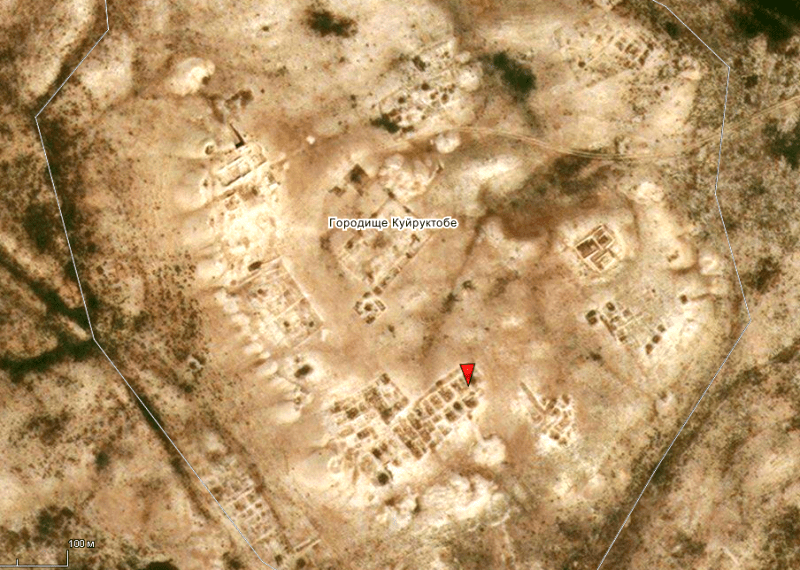
Ancient settlement of Kuyruk-tobe.
.")
.")
Student Tour Aksu-Zhabagly reserve.
“If an ancient man saw planes two thousand years ago
He would've thought they were birds
Or angels from another world
Or messengers from other planets”
Dejan Stojanovic.
Educational Tours around Shymkent.
The medieval settlement of Kuyruk-tobe is located 8.4 kilometers to the north and slightly east of the mouth of the Arys River in the Syr Darya, 4.1 kilometers from the right (eastern) bank of the Syr Darya River, 1.2 kilometers to the west and slightly north of the Arstanbab mausoleum , 4 kilometers west of the Otrar settlement, 3.6 kilometers north-west of the Kogam village and 3.5 kilometers west and slightly south of the Talapty village in the Otrar district of the Turkestan region in the Otrar oasis.
The ancient settlement Kuyryk-tobe (dates back to the period from the first centuries AD to the XVth century) is one of the largest monuments of the Otrar oasis. It is identified with the large city of Keder, which in the IXth - XIth centuries, according to written sources, was the capital of the Farab district.
Opened in 1951 by A.N.Bernshtam, systematic excavations have been carried out since 1981 (K.A.Akishev, K.M.Bay packs, etc.). After around the beginning of n. e. By the IInd half of the VIIth century, it turned into a city (an area of about 5 hectares), surrounded by a wall with towers, probably , being the rate of the place of the right of the government.
In terms of the settlement, it is a trapezoidal hillock with the dimensions of the sides: northeastern - 250 m, western - 125 m, southwestern - 225 m, southeastern - 180 m. The height of the hillock above the surrounding terrain is 7.5 m.
In the south-western corner of the settlement there was a citadel in the form of a rounded hillock with a diameter of about 30 m and a height of 15 m. Remains of towers are still visible at the corners of the wall around the citadel.
The rest of the hillock is the ruins of the shakhristan, which, like the citadel, is surrounded by walls with towers along the perimeter. Traces of buildings are visible around the shakhristan - these are the remnants of a trade and craft suburb.
Excavation at the citadel revealed building structures from three different construction periods. During many years of archaeological work on the territory of the Kuyruk-tobe settlement, a significant amount of material was collected that requires analysis.
On an elevated site of the settlement, a castle-type building was discovered. Excavation at the citadel revealed building structures from three periods. The constructions of the lower initial horizon, related to the palace building, date from the second half of the VIIth - the first half of the IXth century.
On the plan of the preserved part of the palace, the largest area is occupied by the central hall, the dimensions of which are 15 x 10.5 m. Sufas were located along the walls. During the clearing of the hall, a large number of remains of a burnt-out wooden floor and carved boards, decorated with ornaments and scene scenes with images of the Avestan gods and representatives of the nobility, were found.
After drawing and comprehending, the carved wooden decor of the central hall was reconstructed. The composition of the northwestern wall, located behind the throne of the ruler, in a reconstructed form is mounted in the exposition of the Museum of Archeology of the National Academy of Sciences of the Republic of Kazakhstan.
Carved wooden decor adorned the premises that combined the functions of the ceremonial hall and the cult hall "dare-mehr". Nearby was a storage room for the sacred Adurian fire, with a circular podium in the center.
By the decoration of the central hall, one can judge the importance of the Avestan religion (Mithraism) among members of noble families. As shown by the archaeological work carried out at the Kuyruk-tobe settlement, in almost every dwelling of the early medieval period of the VIth - VIIIth centuries. there was a home altar in the central living quarters.
These premises, as well as the central hall of the palace, combined everyday and cultural functions. The altar consisted of an altar niche - a rectangular depression in the wall, outlined by a roller and an altar podium under it. In the houses of the 1XIIh century in Otrar and Kuyruk-tobe, ornamented floor altars were found, testifying to the preservation of relics of the Avestan faith and used despite the domination of Islam.
The religious worldview was reflected in works of art that were included in the system of religious worship and performed certain functions in it. Things used in ritual practice as attributes often have artistic value. In the planned monograph of the settlement of Kuyruk-tobe, it is supposed to consider the pictorial features, semantic the meaning and functional use of artistic ceramics, artistic metal and carved wood, to which three chapters will be devoted.
The structures of the lower horizon belonged to the palace building of the citadel. The building was placed on an artificial platform. The building is poorly preserved. The ceremonial hall is interesting. During the excavation of the ceremonial hall at the floor level and during the excavation of the premises at the level of the lower building horizon, a complex of ceramics was assembled.
During the excavations, two terracotta figurines of Fravashi were found, embossed in molds. Their faces are hunchbacked with almond-shaped eyes. There are earrings in the ears, the heads are crowned with crowns.
Among the finds is an intaglio carnelian seal with a carved image of a horse. During the clearing of the ceremonial hall, a large number of charred woodwork, decorated with carvings, was collected. The closest analogies of carved wood from Kuyryk-Tobe come from Sogd and Ustrushana.
Ornamental motives are typical for the monuments of Shahristan, Urtakurgan. Studies of the early city cathedral mosque are interesting. It was located in the center of the settlement. The mosque was rebuilt. Remains of the walls of square burnt bricks have been preserved from the early construction.
The later mosque was mainly dismantled into bricks for Muslim burials of the 13th-15th centuries. However, from the remaining remains, it was possible to get an idea of its appearance. The dimensions of the building are 36.5 x 20.5 meters.
It stretches from southwest to northeast. In the north-western part, the bases of 16 baked brick bases were cleared from wooden columns on the floor. There were 50 bases in total in the short and 10 in the long. The column spacing is 3 meters.
The mosque dates back to the XIth - XIIth centuries. and belongs to the number of pillar or column buildings. The town also existed in post-Mongol times. Workshops were excavated in Rabad, which date back to the XIIIth - XVth centuries.
The materials of Kuyryk-Tobe are unique in the richness of materials testifying to the high artistic culture of the population of medieval Kazakhstan.
Geographic coordinates of the settlement of Kuyryktobe: N42 ° 51'12.85 "E68 ° 15'09.92"
Authority:
Karl Baipakov, Academician of the National Academy of Sciences of the Republic of Kazakhstan, Director of the Institute of Archeology named after A. Margulan.
Photos from the site
https://bigenc.ru/archeology/text/2119838