


![]()
Вы здесь
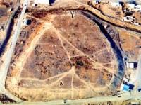
Ikan ancient settlement.
Guide to Turkestan.
"Area near Yassy-Turkestan"
Hafiz Tanysh. Description of the campaign of Abdallah Khan in 1582 in Desht-i Kypchak.
Ancient settlements of Turkestan region.
The settlement of Ikan is located in the central part of the village of Staroikan (Kaz. Eskiygan), which is subordinate to the city administration of the city of Turkestan, 24.4 kilometers south-east of the regional center in the Turkestan region.
The Ikan settlement dates back to the Xth - XVth - XVIIIth centuries. In the XVIIIth century, the town of Icahn gained popularity due to the fact that it was the headquarters of Tursyn Khan (1712 - 1717) and his son Barak (1749 - 1750).
Unfortunately, there is no exact data as to when Icahn was built, which is now a hill. In his work "Abdullanama" Hafiz Tynysh writes that the Bukhara Khan Abdullah in 1582, during a campaign against the Tashkent ruler Baba Sultan, stopped at Ikana.
The famous historian PI Rychkov, who lived in the XVIIIth century in his work "Topography of the Orenburg province", indicated that there were about 300 houses in Icana and its inhabitants were engaged in agriculture. In the Middle Ages, Icahn played a significant role among the cities of the Turkestan region.
At present, the preserved place of the hill is trapezoidal, 6 - 7 meters high and 300 - 225 meters in size. In the south-eastern part, the remains of the citadel are displayed, as well as the outlines of various buildings in structure.
According to the layout, it can be assumed that the gates of the city were in the northwest with several towers from where surveillance outside the city was conducted. Most of the city was destroyed during the construction of new structures.
The 1951 monograph by E. I. Ageeva and G. I. Patsevich contains a plan and topographic survey of the settlement before its destruction. The plan shows the remains of a citadel on the southeastern side of the hill. At present, the dimensions of the hill on the north side are 200 meters, south-west - 210 meters, south-east - 240 meters, north-west - 85 meters.
The total area of the hill is 4.6 hectares. In 1947 the settlement was explored by the South Kazakhstan archaeological expedition (S.N.Bernshtam). In 1999, the Turkestan archaeological expedition examined it for the second time (M.K. Tuyakbayev).
Three exploration excavations were carried out in Shaharistan, two exploration excavations were carried out in the citadel. The first excavation in the citadel consists of 3 building tiers, measuring 2.5 x 2 meters, the second one consists of 6 building tiers, measuring 4.5 x 2 meters.
However, the pits were not opened further from the level of the 9th century, as the lower floors, due to the incessant drainage well, turned into a kind of muddy water. In 1994, the settlement was included in the collection "Chronicle of historical and cultural monuments of Kazakhstan" in the South Kazakhstan region under number 631, and was taken under state protection.
The total land area is 4.7 hectares. Hafiz Tanysh, in his description of the campaign of Abdallah Khan in 1582 in Desht-i Kipchak, called Ikan as “a place near Yassy-Turkestan” [48, p. 282]. However, Ikan (Ikhkan) as a city and birthplace of a number of sheikhs was widely known in the works of Arabic sources of the early XIIIth - XIVth centuries.
This is evidenced by their nisba, while the second nisba connects their origin with Farab [50, p. 86, 135, 150, 160]. In the 18th century, in 1735, Nurmukhammed Alimov reported about Icahn as a city [48, p. 29]. Karl Miller wrote about a small village “Ikant, located 20 versts from Turkestan” in 1738 [48, p. 161-162, 166-168]. In the materials about the trip of the Cossack Ataman Lieutenant Dmitry Telyatnikov and Sergeant Aleksey Beznosikov from the Irtysh line to the Tashkent possessions in 1796, Ikan is called a “shtetl”.
It is also said that Icahn was built by Bukey-Sultan from the Middle Horde. Icahn was ruled by Barak khan, the son of Tursun khan, who in turn captured Icahn in 1717. He died near Icahn in the city of Karnak [48, p. 388-389].
According to Russian sources, Bukey Sultan gathered 200 families here from Tashkent and settled them in Ikan and Turkestan. He himself always lived in this town. The inhabitants of Icahn feed on arable land, they have no cattle breeding, they will have quite abundant cotton paper, from which they dress, and sell the excess.
"In Icana and Turkestan, according to Russian sources, abundant wheat, barley, millet will be born, and from the fruits - melons and watermelons" [48, p. 161-162, 166-167].
Geographic coordinates of the settlement of Icahn: N43 ° 11'20.58 "E68 ° 31'25.16"
Authority and photos:
http://azretsultan.kz/rus/gorodishhe-ikan/