


![]()
Вы здесь
Tour to Ulytau mountains.


Traveling to monuments in Ulytau.
“We leave something of ourselves behind when we leave a place, we stay there, even though we go away. And there are things in us that we can find again only by going back there”
Pascal Mercier. «Night Train to Lisbon».
Short description of tour program from Zhezkazgan to Ulytau mausoleums:
Zhezkazgan town - Terekty valley – Zhoshy-Khan mausoleum - Dombauyl mausoleum - Ketebay and Labak mausoleum – Alasha-Khan mausoleum - Duzen Sandybay necropolis - Ulytau mountain - Altynshchoky mountain – Tamdy petroglyphs – Baykonyr petroglyphs – valley Akzhar – Mount Aulie - Mount Edege Baskamyr ancient settlement and mausoleum Ayakkamyr - Zhezdy village - Zhezkazgan town - Almaty.
Distance of route: 978 km.
Length of hiking part of tour: 8 km.
Season: May - September.
Duration of tour: 7 days 6 nights.
Best time for tour: June - August.
Detailed program of educational tour of Ulytau district in Karaganda region:
Trip to Ulytau Mountains.
Day 1. Zhezkazgan - rock paintings of Terekty (94 km).
Arrival in Zhezkazgan. Meeting at the airport, transfer to hotel, accommodation.
City tour, visit to the historical and archaeological museum of the town.
The museum has more than 25,000 exhibits, here are the bones of a giant rhinoceros that lived in this region 40 million years ago, jewelry and household items preserved from ancient civilizations. The museum has exposition halls: paleontology, nature, archeology and ethnography, an art and exhibition hall.
A visit to the town park of culture and recreation 30 years of Victory, the Square of Metallurgists, the monument to the Metallurgists, the monument to the First Builders of the town, the monument to space explorers, the monument to Abylai-Khan, the monument to the sarbaz-rebels, the monument to Kanysh Satpayev, the monument of glory to the soldiers of the Dzhezkazgan who died in the Great Patriotic War, the temple Apostle Andrew the First-Called.
We will visit Cosmonauts Boulevard, which from 1994 to 2010 was called "Saken Seifullin Boulevard". By tradition, astronauts who returned from space and landed in the Zhezkazgan area in the 1970s - 1980s of the XXth century planted pine trees on Cosmonauts Boulevard.
About the "space" history of Zhezkazgan resembles the stela "Cosmos" and a panel depicting Yuri Gagarin on the house on Nekrasov Street, as well as the monument "Aviation and Cosmonautics".
Transfer: Zhezkazgan - Terekty village - rock paintings of Terekty (94 km).
The historical and archaeological complex of Terekty-Aulie consists of a gallery of rock paintings - Neolithic sites, settlements and necropolises of the Bronze Age, mounds of the early Iron Age, the remains of horizontal and vertical adits, in which ores and semiprecious minerals were mined, tomb of the saint of the XIXth century.
The Terekty petroglyphs are located on the tops of three granite hills stretching from west to east. On the stones are images of animals that can be attributed to the Saks animal style, to the Bronze Age (III - I millennium BC), the early Iron Age (IX century BC - III century AD) and to the Middle Ages.
Walking in the environs, visiting cave paintings and tomd of the saint of the XIX century. End of excursion, return to Zhezkazgan, transfer to hotel, overnight.
Day 2. Town of Zhezkazgan - Ulytau village (171 km)
Breakfast. Transfer: Zhezkazgan - Kengir reservoir - Korganbai village - Kara-Kengir river - Zhoshy-khan mausoleum (50 km).
After we pass the town, our path turns north, to the left of us is the Kengir reservoir, we pass the small village of Kongarbai, the valley Konyrbaisai, the bed of the drying river Basbulak and soon arrive at the necropolis of Zhoshi-Khan. For the first time, the mausoleum of Zhoshi-Khan is mentioned in the notes of Hafiz Tanysh (XVI century).
In 1946, an archaeological expedition led by A. Margulan during excavations discovered two burials in the mausoleum. According to scientists, one of them belongs to Khan-Juchi, the other to his older wife Bektumysh. Walk around the ancient necropolis.
Transfer: Mausoleum of Zhoshy-Khan - Mausoleum of Dombauyl (5 km).
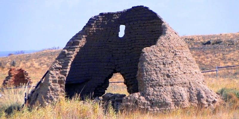
Our path after the mausoleum of Zhoshi-Khan lies to the north-east, along the left bank of the Kara-Kengir River. Arrival at the mausoleum of the Hunnic period Dombauyl. The first written mention of the Dombaul mausoleum is found in Chingiz Valikhanov in the article “On Kyrgyz-Kaisak Graves and Antiquities in General”.
One of the largest stone structures in Kazakhstan, built in the pre-Islamic period, VIII - IX centuries The mausoleum is a tall cone-shaped structure similar to a square.
Transfer: Mausoleum of Dombauyl - Mausoleum of Ketebey and Labak (20 km).
Our path continues further along the left side of the Kara-Kengir River, along the entire length of our path in the riverbed there are small, separate lakes, there is no river here. Arrival at the Koptam Necropolis. Visit to the mausoleum of Konusbai-Labak.
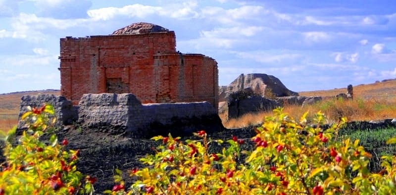
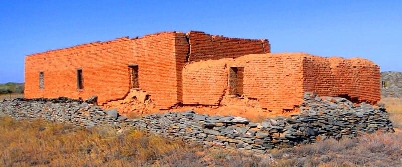
The mausoleum was built in 1874. The Labak Mausoleum is a portal dome structure measuring 7.25 × 8.25 meters and a height of 6.45 meters. The mausoleum was built of adobe bricks, lined with burnt bricks from the outside and inside, the dome is lined with square burnt bricks.
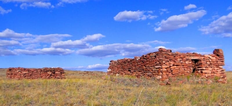
There is also the mausoleum of Ketebay (XIX century). Visit to the mausoleum of Ketebay. The mausoleum is built of adobe bricks and faced with burnt bricks. This is one of the best examples of mausoleums of the XIX century of Central Kazakhstan. The dome is destroyed, restoration work was not carried out.
Transfer: the mausoleums of Ketebey and Labak - the Kara-Kengir river - the mausoleum of Alash-Khan (15 km).
We cross the riverbed and head to the mausoleum of Alash-Khan. Arrival and visit to the mausoleum. The mausoleum of Alash-Khan was erected in the first half of the XIIIth century, built of good burnt square bricks, has a portal dome structure.
The outer masonry of the mausoleum imitates a carpet with alai patterns. According to popular tradition, Alash-khan was a just ruler, brave and brave leader of the Kazakh tribes.
Transfer: Mausoleum of Alash-Khan - necropolis of Duzen Sandybai (23 km).
Arrival at the necropolis for a walk in the vicinity. The Duzen Sandybayuly mausoleum was built in the middle of the XIXth century in 1863 - 1866 by the Kazakh master Seraly Elamanuly by the order of a large feudal lord Erdyn from the Naiman clan over the grave of his brother Zhuzden.
It is a bad copy of the mausoleum of Alash-Khan. The mausoleum is built of burnt bricks on clay mortar. According to the stories of old-timers, sheep’s milk was added in the manufacture of bricks for its strength. The construction of a cubic shape with a hemispherical dome.
Transfer: necropolis Duzen Sandybai - village Kokolen -valley Korylybulak - village Ayyrtau - village Ulytau (58 km).
Arrival in the Ulytau village, transfer to the guest house, accommodation, rest, overnight.
Day 3. Village Ulytau - Tamdy and Baikonyr petroglyphs (159 km).
Breakfast. Transfer: Ulytau village - Tortkara mausoleum (28 km).
From the village of Ulytau we are moving to the north-west. The Tortkara Mausoleum is located on the left bank of the Karatal River (Zhetykiz). Visit the mausoleum and walk around.
Transfer: Tortkara mausoleum - Sarlyk village - Altynschoky mountain (25 km).
Mount Altynshoky, 453 meters high above sea level, is located in the southern part of the Zhylan-Shykturme Upland. Here, on the top of the Altynshoky mountain, there is a copy of Temur’s inscription on a stone slab dating back to 1391. Nearby are the remains of a smelter.
Climbing the mountain and walking in the environs.
Transfer: Altynshoky mountain - Sarytau mountains - Tamdy petroglyphs (34 km).
Tamdy petroglyphs are located on the left bank of the Tamdy River. Petroglyphs of the Tamdy River Valley are characterized by single cave paintings and rare multi-figure scenes, plotted on red and brown diorite and porphyrite sandstones and dispersed at a distance of about 1 kilometer.
Most of the petroglyphs are concentrated in the middle reaches of the river. Here on the surface of massive rocks and rocks destroyed by wind erosion, 18 planes and 130 images were found. Walk around. 1 km south of Tamdy petroglyphs is Tusup mazar. Visit to the mazar of Tusup.
Transfer: Tamdy petroglyphs - Baytleu wintering - Baikonyr petroglyphs (10 km).
The rock paintings of Baikonur are located on the right and left banks of the Tamdy River. Petroglyphs Baykonyr are depicted on flat boulders. Many drawings have copies. Petroglyphs are embossed with a thin object, drawing shapes with thin lines.
On one side are people, roe deer, and reflex, the subject of hunting, and on the other side: moose, horses. In some places you can see running wolves, people on horses, in the background a caravan of camels. Visit of petroglyphs and walk in the environs.
Transfer: petroglyphs Baykonyr - Sarlyk village - Ulytau village (62 km).
From the petroglyphs of Baikonyr, passing Mount Akmambet at a height of 533 meters above sea level, our path lies to the village of Sarlyk and further to the south. In the village of Sarlyk, we turn east and move to the village of Ulytau. Arrival in the Ulytau village, transfer to the guest house, dinner overnight.
Day 4. Ulytau village - Akzhar valley (348 km).
Breakfast. Transfer: Ulytau village - Korgasyn village - Mayatas wintering - Kara-Turgai river - Ekidin village - Akzhar valley (165 km).
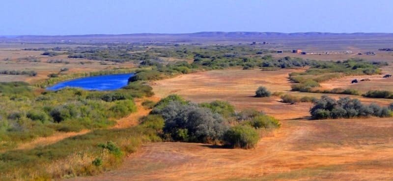
Our path from the Ulytau village to the Akzhar valley lies to the north-west. At 111 kilometers after the village of Ulytau, we cross the border of the Kostanay and Karaganda regions. Arrival in the valley, walks in the environs. The prevailing rocks of Akzhar are colored clays, fine-grained sands and sandstones, the underlying rocks are coarse-grained red sandstone and shale.
The Akzhar valley impresses with its unique and non-repeating colors, these colored clays, millions of years old, the ocean splashed here millions of years ago.
The Akzhar valley is a concentration of greatness and at the same time lifelessness. The vegetation is rare, small the period of vegetation and growth is not long - heat and lack of moisture. The Akzhar valley is a layer of sedimentary rocks with magnificent forms and different soil colors.
At sunrise, incredible views of the surroundings of the tract open. Lunch on nature. On the way back visit the rock paintings of Zyngyrtas.
Transfer: Akzhar valley - Yekidin village - Kara-Turgai river - Mayatas wintering - Korgasyn village - Zhanalayak mountains - Aktasty mountain - Zyngyrtas petroglyphs (165 km).
Petroglyphs Zyngyrtas are located in the valleyt Bezulgai. The name of the surroundings where the petroglyphs are located translates as Sounding. In windy weather, a faint ringing of bells can be heard from somewhere in the distance.
Petroglyphs are located on the crest of the meridional hill along the entire surface of the boulders, which is convenient for knocking out.
Multi-figure compositions with the participation of people, archers and animals: mountain sheep, horses, wild boars, camels, bulls are depicted. The figures of a horseman on a horse, scenes of an erotic nature, a “string” of animals and two faces were recorded. Walk around.
Transfer: petroglyphs Zyngyrtas - Ulytau village (18 km).
Arrival in the village, transfer to the guest house, dinner, overnight.
Day 5. Village Ulytau - Aulie and Edyge mountains (56 km).
Breakfast. Transfer: Ulytau village - Ulytau mountains, root of mountain of Mount Aulie (3 km).
Ulytau Mountains are located in the west of the Ulytau village. The length of the mountains from north to south is 15 kilometers; in the latitudinal direction, the mountains stretch for 11 kilometers. In the east, the natural barrier of the mountains is the village of Ulytau.
The highest point of the mountains is Mount Aulie high 1131 m. a. s. l.
Hiking to the top of Mount Aulie (2 km, 1.5 hours).
Climbing - about 500 meters. Sightseeing at the top of the mountain, here are the burial places of the seven saints and a cave. Descent from the mountain.
Transfer: Ulytau mountains - Ulytau village - Akshoky mountain - root of mountain of Edyge mountain (28 km).
The top of Mount Edyge 1063 meters above sea level are located in the Edyge massif, which are located in the southwest of the Ulytau mountains. The length of the Edyge Mountains is 14 kilometers, the largest width of the mountains is 4 kilometers.
The natural border between the Edyge and Ulytau mountains is the Abas stream, which originates from the southern slopes of the Ulytau mountains.
Hiking to Mount Edyge (2 km, 1.5 hours).
Climbing - about 400 meters. From the top of the mountain offers a beautiful panorama of the surrounding mountains and steppe plains. Visiting the graves of the khans of Tokhtamysh and Edyge located in the vicinity of the peak.
Return to the root of mountain (2 km, 1 hour). Return to Ulytau village (25 km).
A visit to the museum of local history in the village of Ulytau.
Dinner and overnight at the guest house.
Day 6. Village of Ulytau - town of Zhezkazgan (150 km).
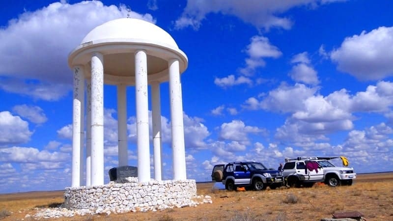
Breakfast. Transfer: Ulytau village - a monument “Unity of the Peoples of Kazakhstan” (10 km).
The monument of unity and solidarity of the Kazakh people on the slope of Mount Aiyrtau was erected in 1992. The monument is the geographical center of Kazakhstan. The sculptural composition represents the four cardinal points. At the very top, at an altitude of 30 meters, the sun-shanyrak was set, from here you can see four figures of argymaks (horses).
The entire area around the monument is decorated with stone sculptures of balbals. Walk around.
Transfer: the monument "Unity of the Peoples of Kazakhstan" - the medieval settlement of Baskamyr (44 km).
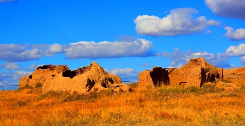
The settlement of Baskamyr is the remains of a medieval castle surrounded by three powerful walls with a citadel and towers. The Baskamyr settlement also includes 2 crypts, a cemetery of the same name, an observation stone tower 3.5 meters high, a system of water channels, begins at the Sarybulak spring, a 20-meter-deep mine at a distance of 1.3 km, and a separate brick building with stone floor.
Researchers attribute Baskamyr to the VIII - XI centuries. The ancient settlement is associated with the construction activities of the Kipchaks. Walk around the settlement and archaeological sites of the Bronze Age settlement.
Transfer: Baskamyr settlement – Karabulak valley - Ayakkamyr settlement and Kutlug-Temir mausoleum (Ayakkamyr) (14 km).
The ancient settlement Ayakkamyr is a highly pollinated square mound. On the ancient settlement there is a moat on three sides; on the fourth south-western side, the remains of structures adjoin the ancient settlement in the form of heavily crumbling elongated mounds and stone walls.
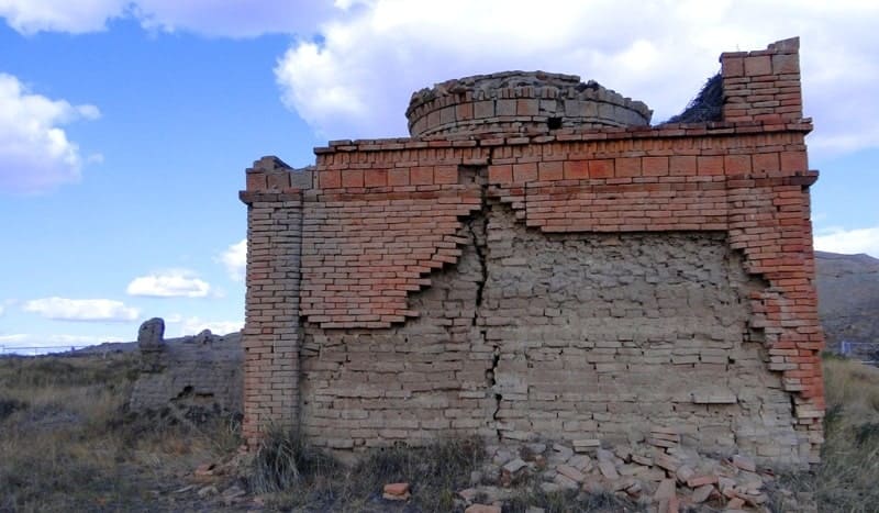
300 meters from the fortress is the mausoleum of Kutlug-Temir (Ayakkamyr). The mausoleum is made of burnt bricks. According to the assumption of A. Kh. Margulan, the mausoleum was built as the tomb of Genghis Kutlug-Temir. The mausoleum is surrounded by a late medieval necropolis.
Walk in the vicinity of the fortifications and the mausoleum.
Transfer: Ayakkamyr settlement - village of Zhezdy (16 km).
Arrival in the settlement of Zhezdy, visit to the Museum of the History of Mining and Smelting. The museum of the history of mining and smelting in the village of Zhezdy was opened on July 15, 1994. The museum’s exposition is located in the open air on an area of 3 hectares, as well as in exhibition halls, the museum’s fund consists of more than 15 thousand exhibits covering the history of mining and smelting, material culture, ethnography and the way of life of the people.
The museum shows history from the Paleolithic to the present.
Transfer: Zhezdy village - Zhezkazgan town (66 km).
Arrival in Zhezkazgan, transfer to hotel accommodation, farewell dinner, overnight.
Day 7. Zhezkazgan - Almaty.
Breakfast. Transfer to the airport, departure to Almaty. Arrival in Almaty, the end of the tour.
Note:
Author program of Alexander Petrov. Copying and introduction - from the sanction of the author.
Alexander Petrov
Photos by: