


![]()
Вы здесь
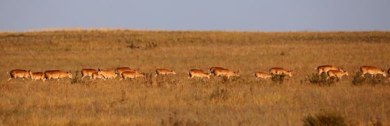
Photo tour of saiga tatarica in Ulytau steppes.
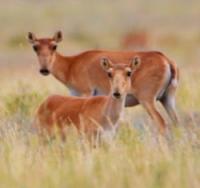
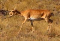
Photo safari for saigas in Kazakhstan.
“A journey is a book. Only those who know how to read between the lines of observed life can read it. Anyone who is looking for the original, the exotic, who is in a “poetic” mood, inevitably falls into error, because in normal conditions of life he is looking for the abnormal.”
E.M. Murzaev.
Faunistic tours in Kazakhstan.
Purpose of photo tour for saiga in Kazakhstan:
a tourist trip for the purpose of photographing a rare animal in its natural habitat.
Brief description of tour program in Ulytau region:
Town of Zhezkazgan - village of Zhezdy - Aktas mine - village of Pioneer - village of Baikonir - site of Bulanty battle - Taldykuduk winter road - grave of Koilybai baksy - Dulygaly mosque - village of Sarlyk - village of Korgasyn - Town of Zhezkazgan.
Route length: 632 km.
Season: May - September.
Duration: 4 days, 3 nights
Best time for tour: June - August.
Detailed photo safari program for saigas tatarica in Ulytau steppes:
Day 1. Zhezkazgan - Baikonir (131 km).
Arrival in Zhezkazgan. Transfer: Zhezkazgan – town of Satpayev – village of Zhezdy – Aktas mine (75 km).
After we pass the town, our path lies to the town of Satpayev, which is located 21 kilometers from Zhezkazgan. After Satpayev, the industrial zone begins and our path goes northwest to the village of Zhezdy. In the village you can replenish your drinking water supplies before heading to the waterless steppe.
In Zhezdy, there is also Internet and mobile communications, there is a shop where you can buy flatbreads. From the village of Zhezdy our path lies to the west, immediately beyond the village to the north of our path there is the Akzhal mountain range.
After about 27 kilometers we will cross a small ford through the small channel of the Bala Zhezdy, which is the left tributary of the Zhezda Bala Zhezdy. Bala Zhezdy in the northern part is formed from three tributaries Kamystykuduk, Kashkansu and Kentexai.
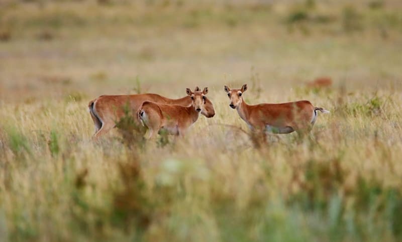
Already here we can have our first encounters with saiga tatarica. Soon, after about 10 kilometers in the north, not far from the road we will see Mount Boztarau. On the eastern side of the mountain there is a spring of the same name, which is the source of the Kamystykuduk River; most likely there may be saiga tatarica here.
We will try to approach them secretly and carefully. There are about 18 kilometers left to the Aktas quartz mine, before reaching the Aktas reservoir, we will turn north and drive about 10 kilometers along the right bank of the Aktas River. These are likely Saiga habitats; perhaps we will be lucky and will be rewarded with the spectacle of ancient animals.
Transfer: Aktas mine – Pioner village (28 km).
From the Aktas mine our path lies south to the highway that connects the villages of Baikonyr and Karsakpai. Aktas and Pioneer are connected by an old, dirt road, which is laid along the left bank of the Aktas River, which continues its flow, passing the Aktas reservoir.
After 11 kilometers we will overcome a small tributary of the Tumyrza-Sarybay, which merges with the Aktas River to form the Baikonyr River. After the Tumyrza-Sarybay River, the typical Ulytau small hills begin, which is characteristic of the steppes of this zone.
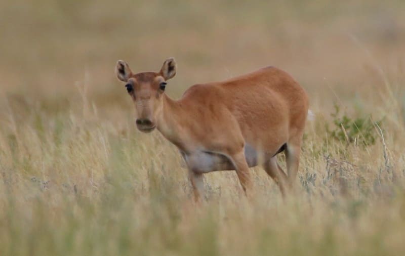
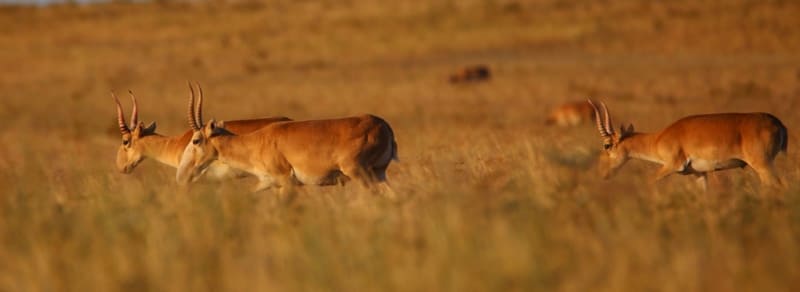
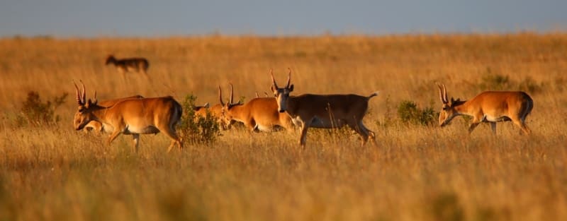
These are the favorite habitats of the saiga tatarica; they are characterized by seasonal concentration - in different seasons of the year they gather in large herds of thousands in certain areas of the steppes and semi-deserts and feed on a wide variety of plant species (quinoa, wormwood, wheatgrass, saltwort, etc.), including those that are poisonous to other species of animals.
In the village of Pioner we pass the small river Sarysay, which, passing a small reservoir on the east side of the village, after 12 kilometers flows from the right into the Baikonyr river. Lunch on the way. We pass the small village of Pioneer and after 5.5 kilometers we reach the highway, grader track and turn right towards the village of Baikonyr.
Transfer: Pioneer village – Baikonyr petroglyphs (28 km).
The village of Baikonyr (translated into Kazakh as a rich valley), according to one version, the name “Baikonyr” is translated from Kazakh as “sandy hills with rich vegetation” or “the area belonging to the bai Konur”. Named in honor of the Kipchak bai Baikonyr, who in 1905 handed over the brown coal mines to the British.
Before this, since 1890, the coal mines belonged to the merchant Surin. The emergence of the village is timed to coincide with the discovery of coal-bearing deposits in outcrops along the banks of the Baikonur rivers by entrepreneurs Surin and Zheleznov in the 90s of the XXth century.
In the abandoned park of the village there is a monument to the Soviet era - V.I. Lenin, you can take a look. We pass the village and our path lies to the rock paintings, which are located on the right bank of the Baikonyr River. Rock paintings are characteristic of the late Bronze and early Iron Ages.
Rock paintings reflect the history of the steppe in all its diversity. In many cases, petroglyphs are carved with a thin object, drawing out figures with thin lines. On one side there are depicted people, roe deer, a bow - the subject of hunting, and on the other side: elk, horses. In some places you can see running wolves, people on horses, and a caravan (camels) in the background.
On the right bank, not far from the rock paintings, there is a good place for a tent camp, here we will stop for the night.
Dinner, overnight in tents.
Day 2. Baikonyr River – Kulenbai-Boksy Zhylynshyk River (171 km).
Breakfast. Transfer: Baikonyr river – Lakbay winter road – Bulanty battle complex (15 km). From our overnight stay our route lies southwest along the right bank of the Baikonir River. Here, encounters with saiga tatarica are more likely, which at this time may be returning from a watering hole from the river.
In Kazakhstan, the saiga tatarica population is divided into the Ural, Betpak-dala and Ustyurt. Saiga tatarica in Ulytau belongs to the Betpak-dala population. In the vicinity of the Lakbai winter road, which is designated on topographic maps as “Name after Stalin,” we ford the Baikonyr River.
Soon we are at the memorial complex to the Battle of Bulanty. The Bulanty Battle complex is located in the southern part of the ancient Uytas cemetery with a melon in the central part. The monument to the Battle of Bulanty was erected in honor of the 550th anniversary of the Kazakh Khanate.
The complex is surrounded by a metal fence, and a massive metal gate was built at the entrance. At the top of the complex there is the main structure symbolizing the inviolability of the khan’s power in the form of a 7-meter metal shaft with a spear on top made of brass and gray marble.
In the lower part there are round shields built on four sides. Around the memorial stele there are 65 marble obelisks, on which the names of the participants in the battle are carved. After visiting the memorial complex, we return to the village of Baikonyr.
Transfer: Baikonyr village – Koilybay baksy grave (95 km).
From the village of Baikonyr ours lies to the north. West of Baikonyr we will cross the Baikonir River along a road bridge and after 1.1 kilometers we will turn right onto a country road. This is a country road known since Soviet times that leads to the grave of Koylybai baksy, the Dulygaly mosque and the Kulmukhamet Ishanu mausoleum.
Also in this direction are the livestock winter roads of the Ulytau region. About 6 kilometers after the bridge over the Baikonir River, we will ford the small bed of the Suresay River, which is the right tributary of the Kargaly. These are the most likely habitats for saiga tatarica and let's hope that we will be lucky enough to see them.
For 26 kilometers we will move northwest to the Kolbay winter road, which is located in the southern part of the Kargaly-Karaadyr mountain range. We will overcome the bed of the Zhosa River along the right bank, which borders the southern spurs of Kargaly-Karaadyr.
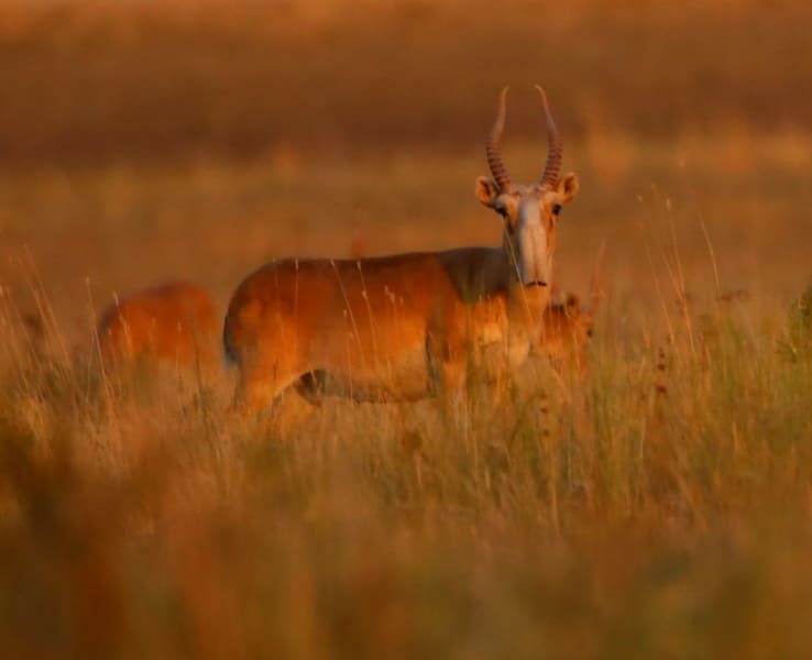
We cross the western part of the mountain range and head to the ford across the Sholak River. The saiga tatarica has an elongated body on thin, relatively short legs. The nose, in the form of a soft, swollen, mobile proboscis with rounded close nostrils, creates the effect of a “humpbacked muzzle” through which the animal cools the frosty winter air and filters dust in the summer.
12 kilometers after the ford of the Sholak River we reach the artesian well Karakuduk, from here the sources of the Kargaly River begin. Stop replenishing drinking water supplies. Starting from the ford across the bed of the Sholak River, our path lies along the left bank of the Dulygaly River and this further increases our chances of meeting saigas tatarica.
After 23 kilometers we arrive at the Taldykuduk winter road, from here our path heads to the northeast. Then we ford the Dulygaly River twice and after 11 kilometers we arrive at the grave of Koylabai baksy. Koilybay-baksy from the Kipchak clan, who lived approximately in the IXth - Xth centuries (exact dates are unknown) was a famous healer (in Kazakh - baksy), as well as a follower of Korkyt.
One of the famous legends associated with Koilybai is the story of how his skill in playing the kobyz helped the Kazakhs defeat the Kalmyks (Dzungars) in horse racing. Visit to the grave. After the grave of Koilybai baksy, we continue our journey along the Dulygaly River and after 6 kilometers we arrive at the Dulygaly mosque and the Kulmukhamet Ishanu mausoleum.
At this point, the Ashchyly River, which has a branched delta, flows into the Dulygaly River from the right. The Dulygaly Mosque was built by Kulmuhammed Ishan Arystanbayuly at the beginning of the twentieth century in the period from 1902 to 1906 from baked bricks.
9 domes crowned the building of the Muslim temple. There was a mosque in operation until 1934; later a madrasah was opened here. In the necropolis next to the mosque lies the famous traditional healer Kazi Ishan, who lived in the 70s of the XXth century. Lunch on the way.
Transfer: Dulygaly mosque – Kulenbay-Boksy Zhylynshyk river (40 km).
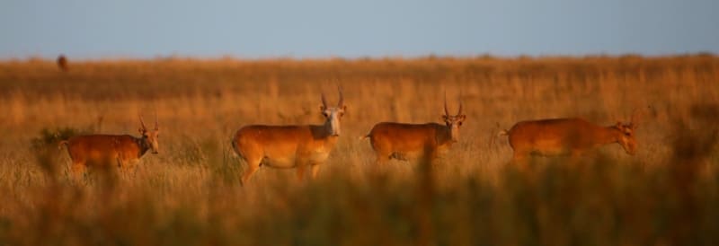
From the Dulygaly mosque we move northwest along the right bank of the Dulygaly river to the Tortmola mausoleum and from here our path turns northeast. We will drive almost 28 kilometers through the steppe expanses of Ulytau. Saigas tatarica migrate long distances and can swim across rivers, but try to avoid steep and rocky slopes.
Saigas tatarica amble, reaching speeds of up to 80 km per hour. Tent camp near the Kulenbay-Boksy Zhylynshyk river, dinner, overnight in tents.
Day 3. Kulenbay-Boksy Zhylynshyk River – (125 km).
Breakfast. Transfer: Kulenbay-Boksy Zhylynshyk river – Balga-Baimyrza winter road - Shagyrly-Zhylanshyk river (36 km).
Our path from the Kuulenbai-Boksy Zhylanshyk River lies to the southeast and further to the east. On this section of the road to the Shagyrly-Zhylanshyk river we pass the Karabidayik valley, the Umbet winter road, which is located just north of our route.
In the vicinity of the Balga-Baimyrza winter road we will move to the opposite side of the Shagyrly-Zhylanshyk river. During this crossing we will have several encounters with saiga tatarica. Saigas tatarica are the same age as mammoths; 90% of this rare animal species is actually found only on the territory of Kazakhstan.
Saigas tatarica are an animal susceptible to stress. It responds to the slightest sounds and minimal movements.
Transfer: Shagyrly-Zhylanshyk river – Sarlyk village (18 km).
After the Shagyrly-Zhylanshyk River, our next place of visit is the village of Sarlyk. We move to the northeast, pass the Bestobe tract and after about 11 kilometers we ford the bed of the Usabaibulak River. Before reaching the village of Sarlyk, we will cross small river beds two more times, one of which is Sarlyk.
In the village of Sarlyk you can replenish your drinking water supplies and visit the local store.
Transfer: Sarlyk village – Tamdy river (30 km.
After the village of Sarlyk we head north, immediately beyond the village to the east of our path lie the Myrzamdit and Tokpambetshoki hills, reaching 552 and 554 meters above sea level. We pass the bed of the Zhetikyz River, the eastern slopes of Mount Akmambet, 533 meters above sea level.
We pass the Teristik valley and soon we are at the Tamdy River. Visit to rock paintings on the left bank of the Tamdy River. Single rock paintings and rare multi-figure scenes are painted on red-brown diorite-porphyritic sandstones. Here, on the surface of massive rocks and rocky outcrops destroyed by wind erosion, 18 planes with 130 images were discovered.
Among them the following percentage is observed:
horses (24%), camels (13%), mountain goats (4%), bulls (3%), anthropomorphic images (10%). Single recorded: a rider on a horse, a predator, a snake, a dog, a bird, as well as vague images (14%). On the Tamdy River, at the ford, there is an excellent place for swimming - a small lake decorated with white water lilies.
Here you can have lunch on the shore.
Transfer: Tamdy river – Korgasyn village (37 km).
On the right bank of the Tamdy River we pass the Baitleu winter road with the right tributary Karasu and our path goes north and a little east. On our way we pass the Baikozha valley, the Akshoki hill 426 meters above sea level, soon we ford the bed of the Terisbutak River and soon we are in the village of Korgasyn.
Animal watching in hilly areas. The village of Korgasyn is located on the right bank of the Karatorgai River, also has a second name - Shenber, is the center of the Shenber rural district and one of the largest settlements in the northern part of the Ulytau region.
The village arose in the XIXth century near the lead deposit, Korgasyn (Kazakh - lead). Near the village you can visit the mines of an old mine, English houses, of which there are several in the village. The thickness of the walls of the house, which is located in the northern part of the village, near an abandoned mine, is about a meter; in general, the house is made in a manner unusual for local architecture.
In the northern part of the village there is the Dabeya mazar Begenuli (Sherapai Mankin). On the route from the Tamdy River to Korgasyn we will meet single and small herds of saiga tatarica several times. This day will be devoted to further observation of these beautiful animals.
Transfer: Korgasyn village – Kara-Turgai river (22 km).
After the village of Korgasyn we head along a road grader, drive 22 kilometers and stop for the night on the right bank of the Kara-Turgai River. A picturesque place with clear river waters is a good place to relax and spend the night. Dinner, overnight in tents.
Day 4 Transfer: Kara-Turgai River – Zhezkazgan (205 km).
Breakfast. Lunch on way. Arrival in Zhezkazgan, end of the trip.
Note:
Author's program by Alexander Petrov. Copying and use of material only with the permission of the author.
Photos by:
Alexander Petrov.