


![]()
Вы здесь
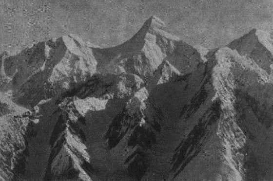
History of peak of Khan-Tengri.


Photo tours to peak of Khan-Tengri.
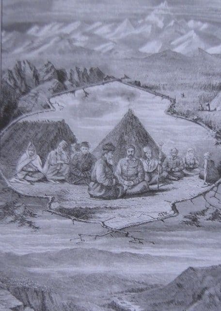
“All the travelers who passed from one side or the other of Khan Tengri were amazed at the enormity of its size, the abundance of snow, etc., but in general they were content only with contemplating it from afar and did not dare to approach this colossus. Only a single traveler, the first Russian explorer of the Tien Shan Semenov, in 1857 penetrated to the glaciers of Sary-Dzhas, descending from Khan-Tengri. The discovery of glaciers was a high scientific feat on Semenov's part."
Researcher of Semirechye Mushketov Ivan Vasilievich.
Kyrgyzstan photo tours.
The first scientist to visit the Central Tien Shan in 1856 - 1857 was P.P. Semenov-Tian-Shansky.
In 1864 - N. A. Severtsova.
In 1869 - A.V. Kaulbars.
In 1876 - A. N. Kuropatkina.
In 1886, an expedition led by mining engineer I.V. Ignatiev visited the Khan-Tengri area. I.V. Ignatiev and his expedition discovered a glacier lying parallel to the Semenov glacier, and named it after the explorer of Central Asia, Mushketov. Having crossed the snowy Tyuz pass in the huge Sary-Dzhas ridge, Ignatiev penetrated into the upper reaches of the left tributary of the Sary-Dzhas River - Inylchek (translated from Kyrgyz as motley mold on the stones). This is already closer to Khan-Tengri.
In 1886 - A. N. Krasnova and I. V. Ignatiev. In 1886 I.V. Mushketov presents a report “Motives and objectives of research on Khan Tengri” to the physical-geographical department of the Russian Geographical Society - on the need to send a complex expedition to Khan Tengri consisting of geologist Ignatiev, botanist Krasnov, topographer and photographer. 12 points were put forward to justify the expedition and its objectives.
n 1889 - Hungarian zoologists G. Alma-shi and III. Stummer-Traufels.
In 1900 - Italian scientists and climbers C. Borghese and G. Brocherel. The Italian geographer and climber C. Borghese, taking with him the alpine guide M. Zurbriggen, who in 1896 conquered the highest peak of the South American Cordillera, almost seven thousand meters high Aconcagua, tried to climb Khan Tengri. He saw the peak from the Aimo-nak pass (4560 meters above sea level) and from there determined that the path to it passes along the Inylchek glacier. The expedition was unable to go further than the pass.
In 1902 - 1903, this area was studied by the German geographer and mountaineer G. Merzbacher and M. Friedrichsen. The German geographer and mountaineer G. Merzbacher played a significant role in the study of the Tien Shan. His first attempt in 1902 to approach Khan-Tengri was made from the Bayankol Gorge.
Having penetrated its upper reaches, the traveler saw Khan-Tengri. Together with guides, Merzbacher climbed to peaks up to 5500 meters above sea level, but never found the way to the foot of Khan Tengri.
The following year Merzbacher was again in the Tien-Shan. This time he headed to Khan Tengri along the gorge of the Sarydzhas River and further along its tributary Inylchek. His guide was Narynkol hunter N.V. Nabokov.
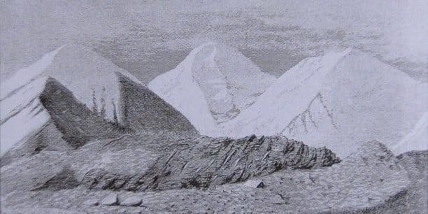
aving reached the Inylchek glacier, Merzbacher walked up it 18 kilometers and reached the confluence of two branches of the glacier. The path to the northern branch was blocked by a large lake. The rocks approaching him seemed inaccessible to Merzbacher.
He directed further efforts to passing the southern branch of the Inylchek glacier. Soon he saw the monumental pyramid of Khan-Tengri from the very base to the top. In his opinion, Khan Tengri looked so terrifying that there was not the slightest hope of conquering him.
Then Merzbacher wrote in his diary: “The Tien-Shan is not a place for mountaineering hobbies.” The maps of the area made by the Merzbacher expedition, as well as the topographic maps compiled by Russian topographers based on the 1912 survey, were for a long time the only cartographic documents of the Central Tien-Shan. On them, the location of Khan Tengri remained conditional.
In 1902-1904 - botany of Tomsk University B.V. Sapozhnikov, in 1912 - Russian topographers.
After the victory of the Great October Socialist Revolution, a real scientific assault on the Central Tien Shan begins. It is visited by numerous groups of scientists and climbers. At the beginning of the 20th century, the Central Tien Shan made sufficient progress in its study.
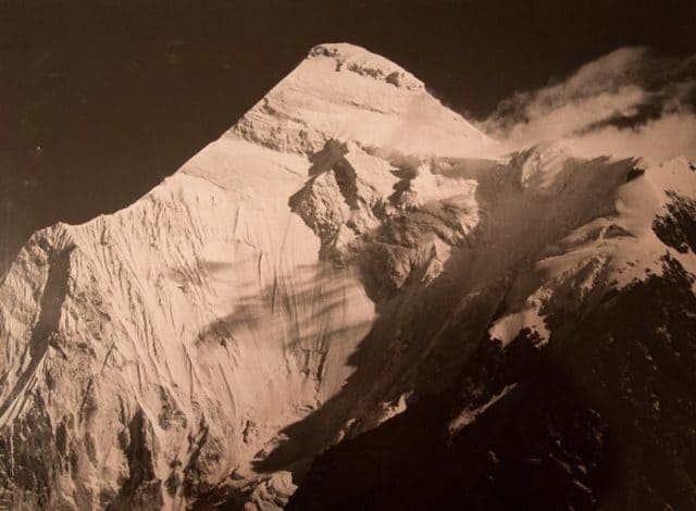
The location of Khan-Tengri and its height were also clarified (information about the height was initially different: I.V. Ignatiev determined it at 7320 meters above sea level, and G. Merzbacher - at 7200 meters above sea level, which, as is now known, wrong).
The listed expeditions expanded the “biography” of Khan Tengri from a geographical point of view. But until the beginning of the 20th century, no attempts had yet been made to climb it.
Systematic exploration of the Central Tien Shan began in 1929 with complex expeditions initiated by the tireless traveler and climber M. T. Pogrebetsky. Groups of Moscow climbers also penetrated into this area. They were led by I. Mysovsky and D. Sukhodolsky.
As a result of these expeditions, the geographical study of the Tien Shan advanced significantly. By that time, Pogrebetsky’s idea of conquering Khan Tengri had become stronger. This is exactly the goal that was set for his 1931 expedition.
There were many difficulties in solving this problem. There was no experience in organizing high-altitude assaults, and there was no production of climbing equipment. The climatic knowledge of the region was still insufficient.
There were no means of communication, and from the moment the expedition left the last populated area, it lost contact with the outside world. All this stood in the way of those who sought to conquer Khan Tengri and begin high-altitude ascents in our country.
Here are entries from their travel diary: “Step and rest. Another step, more rest. The top is no more than a hundred meters away, we can already feel it, but our legs can barely walk. The wind plays with the snow at the very top. Some areas are covered with a thin glazed crust, on which the blown firn rustles.
The wind compresses the snow, and the foot, accustomed to the painful loose snow, rests pleasantly on the springy surface. The wind blew into our faces, and we walk towards it, bending our heads, resting our hands on bent knees.
Step by step we approach at the top, it becomes more relaxed and moves further away from you, and the heart beats like a motor, and frequent rest gives nothing. Our fists are clenched, our teeth are clenched. A few more efforts, a few more steps. But then the wind throws snow in our faces from the top; "The wall we're walking along curves, there's nowhere to go higher. The top!"
At 12 noon on September 11, 1931, Mikhail Pogrebetsky, Boris Tyurin and Franz Zauberer stood on the top of Khan Tengri. This ascent can rightfully be called a feat.
From 1931 to 1933, the Ukrainian scientific expedition conducted its research under the leadership of M. A. Demchenno and A. A. Zhavzharov.
In 1932 - 1933, the Naryn-Khantengry glaciological expedition was led by the well-known geographer Academician S.V. Kalesnik.
In 1935, Evgeny Mikhailovich Kolokolnikov organized the first Kazakh expedition to the Central Tien Shan, to explore climbing routes to the highest point of Kazakhstan, Khan Tengri Peak (6995 meters above sea level). From that moment on, high-altitude mountaineering began in Kazakhstan.
In 1936, Evgeny Kolokolnikov organized an expedition and successfully climbed the Khan Tengri peak, becoming the first Kazakh high-altitude climber and the second conqueror of this peak in the history of Soviet mountaineering.
In 1943, a group of surveyors, topographers and climbers carried out a topographical survey of Mustag and discovered Pobeda Peak.
Since 1945, extensive research has been carried out by the Institute of Geography of the USSR Academy of Sciences. Now they are continued by the Tien Shan high-mountain physical-geographical station of the Academy of Sciences of the Kirghiz SSR.
The second ascent of Khan Tengri took place in 1936. For the next 18 years after this triple victory, no one climbed Khan Tengri.
Only in 1954 climbers again came to Khan Tengri. Then Kazakh climbers led by V. Shipilov reached the summit. For the first time, the ascent to this peak was carried out as part of the national mountaineering championship. Victory over the summit was achieved, and its participants were awarded silver medals.
In 1962, climbers again appeared at the foot of Khan Tengri. They were led by A. Maryashev. The assault ended in victory.
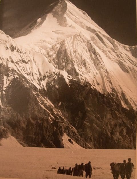
Difficult peaks attract brave athletes. Climbers from various cities of the Soviet Union come here every year to conquer the icy circuses of Khan Tengri and Pobeda and other peaks.
After 33 years, another route to climb Khan Tengri was discovered. At the moment, there are nine different routes to climb this peak. Climbers, having climbed to the top, write messages in pencil for the next climbers who will climb Khan Tengri Peak. The message indicates the name and date of ascent.
In 1964, the first assault on Khan Tengri was undertaken along a new, more complex route. Then Moscow climbers from the Trud sports society, led by B. Romanov, stormed the summit from the South Inylchek glacier along the steep southern ridge (it was called Marble rib).
Their fellow countrymen from the sports society "Burevestnik", led by K. Kuzmin, were the first to plan an ascent from the Northern Inylchek glacier. Both teams successfully completed their routes and were awarded gold medals and honorary titles of national mountaineering champions.
The victories over Khan Tengri did not end with these difficult ascents. In 1964, twelve more climbers from the Trud sports society took the classic route to the summit. For the first time, the winners included a female climber L. Romanova.
In 1968, the Kazakh Spartacists under the leadership of B. Studenin achieved victory over Khan Tengri. They made the first traverse of the highest part of the Sredinny (Khantengri) ridge from the Shater massif to Khan Tengri. The winners were awarded gold medals and received the title of champions.
In the same year, their fellow countrymen, led by Yu. Golodov, repeated the passage of the Marble Rib of Khan Tengri. Since 1970, ascents to Khan Tengri have been held annually, and every year more than one team of climbers strives to reach its summit.
They successfully complete the classic route along the western edge, as well as new, increasingly difficult routes. Among the conquerors of Khan Tengri are climbers from Kyrgyzstan, Muscovites and Leningraders, Uzbeks and Ukrainians, climbers from Krasnoyarsk and Kamchatka. Climbing Khan Tengri became a real test of skill.
Of the many assaults carried out over the years, the first to be noted is the passage of the Northern Wall (1974), as well as two traverses (1971 - 1974). In the traverse of 1971, the climbers of Kyrgyzstan, led by V. Kochetov, distinguished themselves.
They traversed the Sredinny Range from Gorky Peak to Khan Tengri. The route is difficult. It passed at an altitude of more than 6000 m mainly along firn and ice ridges with deep drops. For their success in this traverse, the athletes were awarded the titles of national champions in this climbing class and gold medals.
In 1974, six teams stormed the summit. The most persistent attack was on the Northern Wall, which was passed along parallel routes by Muscovites (leader E. Myslovsky) and Kazakhs (leader B. Studenin). Success accompanied both teams; they became winners in the championship. Their participants were awarded gold medals and honorary titles of national champions.
Our climbers on Khan Tengri have achieved remarkable achievements. Twelve successfully completed ascents became prize money in championships; 31 of their participants were awarded a gold medal and the title of champion, 36 - silver and 14 - bronze medals.
In 2000, it was 100 years since the first attempt to climb Khan Tengri.
In 2001, the 70th anniversary of the first ascent was celebrated.
Notes on the top of Khan Tengri peak.
These messages are stored in a special capsule, which is piled with stones on top. Despite the many accidents that occur during climbing, climbers continue to climb this seven-thousander every year. It takes at least 14 days to reach the top of the mountain. Many peaks with a height of 6000 meters or more are located near Khan Tengri Peak. There are beautiful mountain valleys with many lakes and rivers flowing through them.
Authority:
“Issyk-Kul. Naryn" encyclopedia, Frunze, 1991. "Kyrgyzstan", publishing house "Mysl", Moscow, 1977.
http://wiki.risk.ru/index.php/%D0%A5%D0%B0%D0%BD-%D0%A2%D0%B5%D0%BD%D0%B3%D1%80%D0%B8