


![]()
Вы здесь
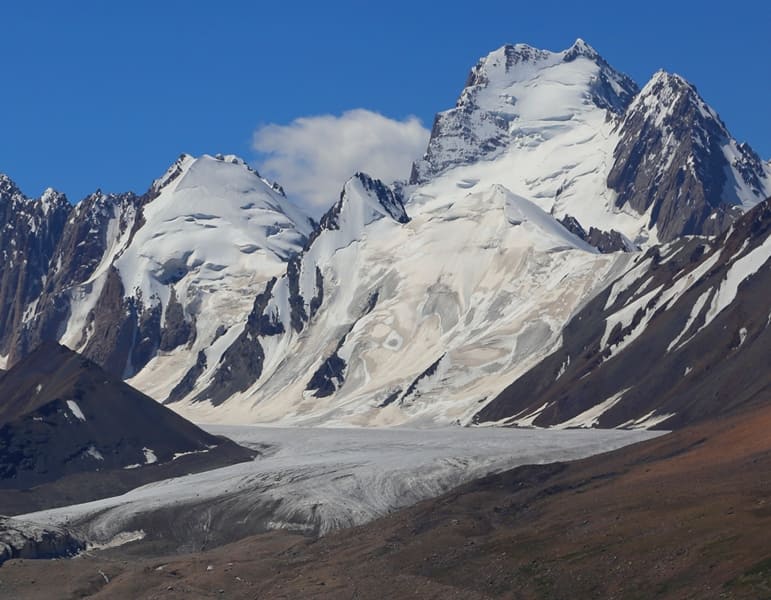
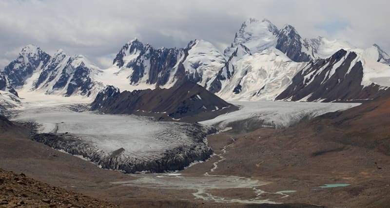
Komarov Glacier (Kyzylunet) West.
 West Glacier No. 78.")
Glaciers located at headwaters of Kyzylunet River in Kakshaal-Too Range.
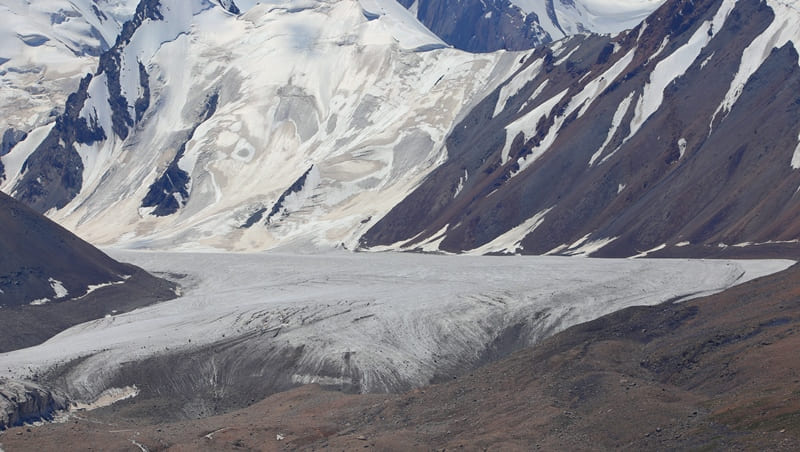
"I named the glacier located at the headwaters of the Kyzyl-Unet after V. L. Komarov, Vice President of the USSR Academy of Sciences and Scientific Secretary of the State Russian Geographical Society. As mentioned, this glacier is striking in the abundance of ice masses spread widely across the gorge. With a maximum length of 11.9 km and a maximum width of 4.2 km, its configuration seems not like a huge ice river, but something akin to a sea bay."
N. N. Palgov. "Along Central Tien-Shan." 1929.
"Glaciers of the upper Ak-sai River flow from Kak-Shaal-tau onto a broad plateau known as the Kogalya-chap ridge. The relief of this plateau-lake, with its enormous boulders, reveals its glacial origin. Therefore, all the glaciers of the upper Aksai can be considered the remnants of an ancient glacier, which in its final stages of retreat resembled Alaskan glaciers. It is interesting to note that the main glacier in this region, Kizil-unet (Komarov Glacier), still exhibits a similar character. It consists of three parallel branches, each with its own feeding area. Merging, they form a massive stream 4-5 kilometers wide."
A. Letavet, V. Nemytsky. "New Data on Glaciation in the Chakyr-Korum, Borkoldoy, and Kak-shaal Ridges" (August 1 - September 1, 1933).
Excursion to Kyzyl-Asker Ice Massif.
Komarov Glacier (Kyzylunet) West No. 78 is located in Kyzyl-Asker mountain range, on northern slope of western Kokshaal-Too Range at headwaters of Kyzylunet River in Atbashi district of Naryn region. The upper boundary of the glacier is at an altitude of 5,258 meters above sea level (Neizvestny Soldat peak), and the tongue of the glacier is at an altitude of 4,094 meters above sea level.
Kyzyl-Asker West No. 78 Glacier extends for 7.6 kilometers, reaching a maximum width of 1.1 kilometers in its lower part and 1.1 kilometers in its central part. Its area reaches 8.27 square kilometers, with a perimeter of 19.3 kilometers. The glacier is divided by two parallel spurs that extend from the main ridge of the Kakshalal-Too Range and descend along the northern slope of the ridge, dividing the glacier into three parts: The upper boundary of the glacier is located (from west to east): at an altitude of 5,300 meters above sea level (Neizvestny Soldat Peak), 5,285 meters above sea level (Babushka Peak), and 4,969 meters above sea level (Komarov Vostochny Pass).
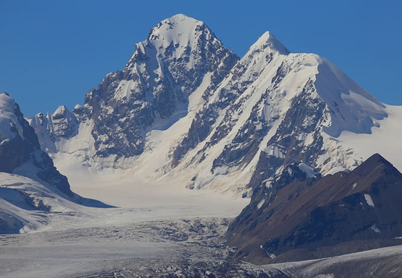
On the southern side, the upper reaches of the glacier border the ice massif of the Eastern Rudnev Glacier, located on the southern slope of the Kakshaal-Too Range in the People's Republic of China. On the eastern side, the glacier borders the ice massif of the Central Komarova Glacier, which is 9.4 kilometers long, covers an area of 9.76 square kilometers, has a perimeter of 24.68 kilometers, and reaches a maximum width of 1.8 kilometers at the top.
On the western side, the glacier borders the Kyzyl-Asker East Glacier No. 80, which is 7.4 kilometers long, covers an area of 9.06 square kilometers, has a perimeter of 35.65 kilometers, and reaches a maximum width of 1.7 kilometers in the central part.
In the southeastern part, the glacier borders the Central Komarova Glacier for 500 meters.
This is how Nikolay Nikitich Palgov describes his exploration of Komarova (Kyzylunet) Glacier in his book "Along Central Tien-Shan," published in 1930.
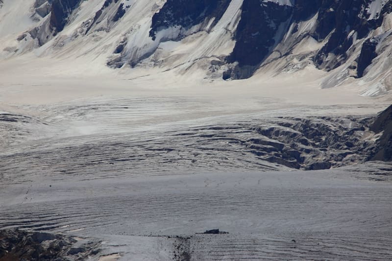
"Streams flowing from the glacier, after passing the first (newest) frontal moraines, form three powerful muddy streams, which then spread into numerous branches, occupying a smooth, pebble bed 300 - 500 meters wide. The banks of the bed are often heavily saturated with water.
This latter, swamping the area with the formation of slushy spaces, comes from the lateral slopes of the mountain spurs surrounding the valley. These spurs in their upper parts bear snowfields, producing numerous streams. One such stream on the right side of the glacier is quite spectacular.
Running down the slope, it stretches into a long, thin waterfall, some ten meters high. By collecting a significant amount of water in this way, the streams acquire impressive volumes. dimensions. If they were all concentrated in a single channel, fording such a river would be impossible.
Despite the very slight slope of the valley (only 1°), the streams flow quite rapidly. The lowest point of the V. L. Komarov Glacier's terminus lies at an altitude of 3,852 meters above sea level. The upper boundary of its firn fields, according to rough estimates (angle of dip and length of the glacier), is at least 4,600 meters above sea level.
The thickness of the glacier at its lower end, approximately at the line of the highest point of its forehead, is 50-70 meters. The glaciated area within the boundaries of the military topographic survey is 24.6 square kilometers, and with the slopes feeding the glacier, it is significantly larger.
A description of Komarov Glacier (Kyzylunet) research by A. Letavet and V. Nemytsky in book "New Data on Glaciation in Chakyr-Korum, Borkoldoy, and Kak-Shaal Ranges" (August 1 - September 1, 1933).
"The glaciers of the upper Aksai River flow from Kak-Shaal-tau onto a wide plateau known as the Kagalyachap valley. The relief of this plateau-lake, with its enormous boulders, reveals its glacial origin. Therefore, all the glaciers of the upper Aksai can be considered the remnants of an ancient glacier, which in the final stages of its retreat resembled Alaskan glaciers.
It is interesting to note that the main glacier in this region, Kizilunet (Komarov Glacier), still has a similar character. It consists of three parallel branches, each with its own feeding area. Merging together, they form a massive stream 4-5 kilometers wide.
The firn basins of these sources are elongated. The glacier tongue resembles part of a circle with a very large radius. The Kizil-Unet River flows from the glacier in three streams: the most powerful, the middle one, emerging from the most prominent part of the arc.
The middle stream emerges not from beneath the ice wall, which reaches 40 meters here, but from its center, bursting out of an ice tunnel and forming a powerful waterfall of yellowish water. The moraines were described by Palgov, and we will not dwell on them.
We conducted the following measurements on this glacier. On the brown cliffs of the right eastern bank of the valley, approximately 1/2 kilometer from the tongue, on the first ledge coming from the bottom of the valley, a cairn was built, from which the following marks were made with a compass:
1) to the protruding part of the glacier (waterfall) (point No. 2 - azimuth 226°C1.5
2) to the source of the left river (eastern, point No. 4) - azimuth 178°.0
3) the highest point of the ridge dividing the left branch from the middle - azimuth 177°.
On the ledge of an old moraine on the left bank of the river (point No. 5 opposite the yellow cliffs), a cairn was built, from which the following marks were made:
1) to point No. 1 - azimuth 53°.5
2) to the waterfall - azimuth 63°.5. Due to lack of paint, no marks were made."
Geographic coordinates of Komarov Glacier (Kyzylunet) Western No. 78: N41°04'36 E77°22'19
Authority and photos by:
Alexander Petrov.