


![]()
Вы здесь
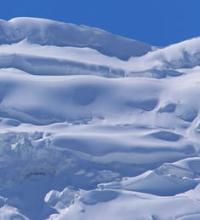
Dihadang Glacier.
Glaciers of northern slope of Zeravshan ridge.
“Nature will act on us with all its strength only when we bring our human beginning into the feeling of it, when our state of mind, our love, our joy or sadness comes into full harmony with nature and it will no longer be possible to separate the freshness of the morning from the light beloved eyes and the measured noise of the forest from thinking about the life lived.”
Paustovsky K. G.
Trips around Sughd region.
Dihadang glacier is located on northern slope of Zeravshan ridge, in upper reaches of river of same name, in Kukhistoni-Mastchokh district, Sugd region. The glacier is located on the northern slope of the Zeravshan ridge and belongs to the Zeravshan River basin.
The Dahidang River, 12.5 kilometers long, is a left tributary of the Zeravshan River. The sources of the river are located at an altitude of 3779 meters above sea level. The left tributary originates from the Dihidang West glacier. The mouth of the river is located at an altitude of 2499 meters above sea level.
The glacier consists of three branches: Central, Western and Eastern.
Dihadang Glacier Central.
The upper boundary of the glacier is located at an altitude of 4494 meters above sea level, the end of the glacier is at an altitude of 3713 meters above sea level. The length of the glacier is 1.9 kilometers, the area of the glacier reaches 2.08 square kilometers, the perimeter of the glacier is 7.84 kilometers, and the average width is 1.2 kilometers.
Geographic coordinates of Dihadang Central glacier: N39°22'04 E70°07'36
Dihadang Glacier Western.
The upper boundary of the glacier is located at an altitude of 4561 meters above sea level, the end of the glacier is at an altitude of 3780 meters above sea level. The length of the glacier is 1.47 kilometers, the area of the glacier reaches 0.48 square kilometers, the perimeter of the glacier is 3.96 kilometers, the average width of the glacier reaches 860 meters.
Geographic coordinates of Dihadang West glacier: N39°22'25 E70°05'53
Dihadang East Glacier.
The upper boundary of the glacier is located at an altitude of 4135 and 4175 meters above sea level, the end of the glacier is at an altitude of 3763 meters above sea level. The length of the glacier is 2.04 meters, the area of the glacier reaches 1.05 square kilometers, the perimeter of the glacier is 7.06 kilometers, the average width of the glacier reaches 550 meters.
Geographic coordinates of Dihadang East Glacier 1: N39°22'27 E70°08'11
Geographic coordinates of Dihadang East 2 glacier: N39°22'50 E70°08'47
Historical information about Dihadang glacier.
Observations of the glacier began in 1959. From 1977 to 1991, the glacier retreated 180 meters. The average retreat rate is 13 meters per year. However, like other glaciers, this speed increased towards the end of the last century: only from 1990 to 1991, the Dihadang glacier retreated by 60 meters at once, which indicates an intensification of the degradation process.
In addition, the surface of the glacier is subsiding due to melting by an average of 1 meter per year.
Authority:
"Glaciers of Tajikistan". Ministry of Nature Protection of the Republic of Tajikistan. Main Directorate for Hydrometeorology and Natural Environment Observations. Dushanbe. 2003.
Photos by:
Alexander Petrov.