


![]()
Вы здесь
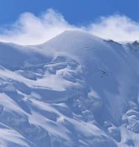
Glacier of Hydrographic Party.
Glaciers of northern slope of Gissar ridge.
“The river flows in a narrow gap, the steep rocky banks and the tracks rise to a great height. The road follows cornices or laid in soft scree, or carved into rocks; in some places it passes along balconies built on the side of the rocks above the river.”
A. P. Fedchenko. “Information about the journey through the Kokan Khanate.” 1871.
Trip from Penjikent to Lake Iskanderkul.
Tar glacier of HGP (Hydrographic Party) is located on northern slope of Gissar ridge, in upper reaches of Zombar River, in Penjikent region, Sughd region. The glacier is located on the northern slope of the Gissar ridge and belongs to the basin of Lake Iskanderkul. The Zombar River, 8.6 kilometers long, is a left tributary of the Mura River.
The glacier consists of three branches: Central, Western and Eastern.
Glacier of Hydrographic Party Central.
The upper boundary of the glacier is located at an altitude of 3850 meters above sea level, the end of the glacier is at an altitude of 3572 meters above sea level. The length of the glacier is 970 meters, the area of the glacier reaches 0.49 square kilometers, the perimeter of the glacier is 3.56 kilometers, and the average width is 740 meters.
Geographic coordinates of glacier of Central Hydrographic Party: N38°56'56 E68°16'39
Glacier of Western Hydrographic Party.
The upper boundary of the glacier is located at an altitude of 4001 meters above sea level, the end of the glacier is at an altitude of 3597 meters above sea level. The length of the glacier is 1.2 kilometers, the area of the glacier reaches 0.48 square kilometers, the perimeter of the glacier is 3.96 kilometers, the average width of the glacier reaches 420 meters.
Geographic coordinates of glacier of Western Hydrographic Party: N38°56'22 E68°16'14
Glacier of Vostochny Hydrographic Party.
The upper boundary of the glacier is located at an altitude of 3920 meters above sea level, the end of the glacier is at an altitude of 3685 meters above sea level. The length of the glacier is 560 meters, the area of the glacier reaches 0.12 square kilometers, the perimeter of the glacier is 1.44 kilometers, the average width of the glacier reaches 150 meters.
Geographic coordinates of glacier of Vostochny Hydrographic Party: N38°56'59 E68°17'12
Historical information about glacier of Hydrographic Party.
The first observations on the glacier were carried out in 1968, and in the period 1971 - 1974. Every summer, a comprehensive glaciological expedition of the State Geological Enterprise of the Hydrometeorological Service of the Tajik SSR worked on the glacier, after which the glacier received its name.
The glacier is in the stage of degradation. From 1968 to 1976 it retreated 18 meters at an average rate of 2.2 meters per year. At the same time, it lost 3,100 square meters of area, its surface decreased by 3.6 - 4.0 meters. Then the rate of its retreat increased: from 1982 to 1990, the glacier retreated 63.1 meters at an average rate of 7.9 meters per year.
From 1968 to 1986, out of a total volume of 11,000,000 cubic meters, the glacier lost 3.9,000,000 cubic meters, i.e. 36.1% of its mass. The average weight loss per year was 2% per year. For 1989 - 1990 The glacier retreated 12 meters and dropped 4 meters, losing more than 1,000,000 cubic meters of ice.
Currently, its degradation has slowed down somewhat, the glacier is retreating by about 1 meter per year. Thus, like all other glaciers in the Zeravshan River basin, the HGP (Hydrographic Party) glacier is intensively degrading, losing mass both as a result of the retreat of the tongue and as a result of the melting of ice from the surface
Authority:
"Glaciers of Tajikistan". Ministry of Nature Protection of the Republic of Tajikistan. Main Directorate for Hydrometeorology and Natural Environment Observations. Dushanbe. 2003
Photos by:
Alexander Petrov.