


![]()
Вы здесь
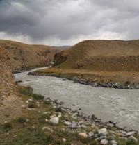
Maytor River.
Rivers and lakes of Kyrgyzstan.
“Travel is a new positive experience that we need”.
List of rivers of Kyrgyzstan.
Maytor River is located at an altitude: its sources are 4505 and 4534.1 meters above sea level, its mouth is at an altitude of 3231 meters above sea level, river belongs to Saryjaz River basin and is a left tributary of Baralbas River, originating from northwestern slopes of eastern part of ridge Kokshaal-Too is located in Jety-Oguz district in south of Issyk-Kul region.
The Maytor River, 30 kilometers long, merges with the Borkolda River and receives the name Baralbas. In addition to the described rivers, the Maytor River receives 7 small, nameless tributaries on the right, and 15 small tributaries on the left side.
At an altitude of 3578 meters above sea level, the main channel of the river is formed, consisting of 2 tributaries. The right, eastern tributary Maytor originates from the small Maytor glacier located on the northwestern slope of the Kokshaal-Too ridge.
The area of the Maytor glacier is 1.02 square kilometers, the perimeter is 5.78 kilometers. The length of the glacier reaches 1.3 kilometers. The sources of the glacier are located at an altitude of 4505 meters above sea level. The sources of the left, western tributary Maytor are located at an altitude of 4534.1 meters above sea level. The mouth of the Maytor River is located at an altitude of 3231 meters above sea level.
Geographic coordinates of Maytor River: N41°31'11 E78°20'30
Right tributaries of Maytor River.
Minteke River.
After 26.5 kilometers from the beginning of the Maytor sources, the Minteke tributary, 17.5 kilometers long, flows into the right. The sources of the river are located on the western slopes of the Ak-Zoo ridge located in the interfluve of Pikertyk, Barlbas and Minteke at an altitude of 4425 meters above sea level. Minteke receives 7 small unnamed tributaries on the left. The mouth of the river is located at an altitude of 3285 meters above sea level.
Geographic coordinates of Minteke River: N41°34'19 E78°26'59
Karabel River.
After 20.2 kilometers from the beginning of the Maytor sources, the Karabel tributary, 20.5 kilometers long, flows into the right. At an altitude of 3573 meters above sea level, the river is formed by two main tributaries: Karabel Western and Karabel Eastern, which originate from small glaciers located on the northwestern slope of the Kokshaal-Too ridge.
Karabel Vostochny River, 19 kilometers long, receives its sources from the Karabel Vostochny glacier located on the northwestern slope of the Kokshaal-Too ridge. The sources of the glacier are located in the main ridge of the ridge at an altitude of 4562 meters above sea level.
The area of the glacier is 1.79 square meters, the perimeter reaches 5.92 kilometers. The length of the glacier is 1.4 kilometers. The Karabel Western River, 7.5 kilometers long, receives its sources from the Karabel Western glacier located on the northwestern slope of the Kokshaal-Too ridge.
The sources of the glacier are located in the main ridge of the ridge at an altitude of 4653.1 meters above sea level. The area of the glacier is 1.54 square meters, the perimeter reaches 7.53 kilometers. The length of the glacier is 2.5 kilometers.
Minteke receives 7 small unnamed tributaries on the left. The mouth of the river is located at an altitude of 3285 meters above sea level.
Geographic coordinates of Karabel River: N41°32'00 E78°24'35.
River Kokryum.
After 13.2 kilometers from the beginning of the sources of the Karabel River, the Kokryum tributary, 12 kilometers long, flows into the left. The Kokryum River receives its sources from the Kokryum glacier located on the northwestern slope of the Kokshaal-Too ridge.
The sources of the glacier are located in the main ridge of the ridge at an altitude of 4395 meters above sea level. In the western part of the glacier in the main ridge of Kokshaal-Too there is a pass of the same name. The area of the glacier is 0.67 square meters, the perimeter reaches 4.17 kilometers.
The length of the glacier is 1.5 kilometers. On the right the river receives 11 small, nameless tributaries, on the left 7 tributaries flow into the river.
Geographic coordinates of Kokryum River: N41°30'50 E78°24'58
Uurusu River.
After 13.8 kilometers from the beginning of the sources of the Maytor River, the Uurusu tributary, 8.2 kilometers long, flows into the right. The sources of the river are located on the western slope of the submeridional ridge, which in its southeastern part adjoins the main ridge of the Kokshaal-Too ridge at an altitude of 4695 meters above sea level.
On the right, the river receives 8 small, nameless tributaries, and one tributary adjoins on the left.
Geographic coordinates of Uurusu River: N41°28'31 E78°23'01
Bedel River.
13 kilometers from the beginning of the sources of the Maytor River, the Bedel tributary flows into the right, length 12 kilometers. The main channel of the river is formed at an altitude of 3612 meters above sea level. The river receives its sources from the Bedel glacier located in the main ridge of the ridge at an altitude of 4877.8 meters above sea level.
The area of the glacier is 2.73 square meters, the perimeter reaches 9.61 kilometers. The length of the glacier is 4.5 kilometers. On the right the river receives 12 small, unnamed tributaries, 7 tributaries on the left. One of the left tributaries of the river receives its sources from the northern slope of the Bedel Pass, located in the main ridge of the Kokshaal-Too ridge at an altitude of 4284 meters above sea level.
Geographic coordinates of Bedel River: N41°27'14 E78°24'28
Left tributaries of Maytor River.
Bozjalpak River.
After 16.6 kilometers from the beginning of the sources of the Maytor River, the Bozdjalpak tributary, 22 kilometers long, flows into the left. At an altitude of 3602 meters above sea level, the main channel of the river is formed, consisting of several tributaries.
One of the tributaries originates from the Bozdzhalpak glacier located on the northwestern slope of the Kokshaal-Too ridge. The area of the glacier is 0.93 square kilometers, the perimeter of the glacier reaches 4.94 kilometers. The sources of the glacier are located at an altitude of 4508.8 meters above sea level. The length of the glacier is 1.17 kilometers.
Geographic coordinates of Bozjalpak River: N41°28'40 E78°15'05
Right tributaries of Bozzhalpak River.
Kuljator River.
After 12.8 kilometers from the beginning of the sources of the Bozdjalpak River, the 11.2-kilometer-long Kuldzhator tributary flows into the right. At an altitude of 3799 meters above sea level, the main channel of the river is formed, consisting of two tributaries - Eastern Kuldzhator and Western Kuldzhator.
Eastern Kuldzhator tributary, 900 meters long, originates from the East Kuldzhator glacier located on the northwestern slope of the Kokshaal-Too ridge. The area of the glacier is 2.17 square kilometers, the perimeter of the glacier reaches 8.08 kilometers.
The sources of the glacier are located at an altitude of 4657.5 meters above sea level. The length of the glacier is 1.87 kilometers. Western Kuldzhator tributary, 1.4 kilometers long, originates from the East Kuldzhator glacier located on the northwestern slope of the Kokshaal-Too ridge.
The area of the glacier is 2.24 square kilometers, the perimeter of the glacier reaches 6.21 kilometers. The sources of the glacier are located at an altitude of 4741.8 meters above sea level. The length of the glacier is 2 kilometers. The mouth of the Kuldzhator River is located at an altitude of 3532 meters above sea level.
Geographic coordinates of Kuldzhator River: N41°26'35 E78°15'26
Kyzylchirko River.
After 16.5 kilometers from the beginning of the sources of the Bozdzhalpak River, the Kyzylchirko tributary, 8 kilometers long, flows into the right. At an altitude of 3744 meters above sea level, the main channel of the river is formed, consisting of two tributaries.
The river originates from the northwestern slope of the Kokshaal-Too ridge. The sources of the river are located at an altitude of 4397 meters above sea level. The mouth of the Kyzylchirko River is located at an altitude of 3459 meters above sea level.
Geographic coordinates of Kyzylchirko River: N41°27'23 E78°17'07
Murodzhan River.
7.5 kilometers after the confluence of the Bozdjalpak tributary into the Maytor River, the Murodzhan tributary, 7.5 kilometers long, flows into the Maytor River. The river takes its source from the northern slope of the Murodzhan Pass, 3805.6 meters above sea level, which is located on the eastern slope of the Borkoldoy ridge.
Geographic coordinates of Murodzhan River: N41°33'09 E78°18'41
Authority and photos by:
Alexander Petrov.