


![]()
Вы здесь
Tour to petroglyphs of Saimaluu-Tash.
Trips to petroglyphs of Saimaluu-Tash and Son-Kol lake.
"As for me, one of the most joyful moments of life is the beginning of a journey into uncharted lands. Shaking off with one mighty effort the shackles of Habit, the lead weight of Routine, a cloak sewn from numerous Cares, and the slavery of Civilization, a person will again know happiness.".
Richard Burton. December 2, 1856.
Excursions to rock paintings of Kyrgyzstan.
Short description of tour route to rock paintings of Saimaluu-Tash and Son-Kol Lake in Naryn region:
Bishkek - Tokmok town - Kemin town - Boom gorge - Orto-Tokoy reservoir - Kochkor town - Naryn town - Kazarman town - Saimaluu-Tash petroglyphs - Dzhany-Talap village - Son-Kol lake - Kochkor town - Bishkek city.
Distance of tour: 1106 km.
Season: from 10 of July to August 30.
Duration of tour: 6 days, 5 nights.
Best time tour: July – August.
Distance active part of tour: 19 km.
Detailed program of excursion walks in mountains of Ferghana Range:
Day 1. Bishkek - Naryn (317 km).
Transfer: Bishkek - Tokmok yown - Kemin town - Boom gorge - Orto-Tokoy reservoir - Kochkor town (196 km). Lunch at a cafe in Kochkor village.
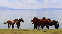
Further transfer: Kochkor town - Sary-Bulak village - Dolon pass 3038 meters above sea level - Kara-Unkur village - Ottuk village - Naryn town (121 km). After the town of Kochkor we will cross the western part of the Terskey Ala-Too ridge. On our way we will meet a small village of Sary-Bulak from which a little more than 60 kilometers remain to Son-Kol Lake. We pass the picturesque Dolon Pass in the vicinity, which is home to numerous yurts with herds of horses, flocks of sheep and herds of cows.
ere you can try the national drink of the Kyrgyz - koumiss and taste real ayran. After the pass, the road descends along the valley of the Kara-Unkur River, which in the vicinity of the village of Ottuk gets the name - Ottuk. Arrival in Naryn, hotel accommodation, walk around the town, dinner, overnight.
Day 2 Naryn - Kazarman (214 km).
Breakfast. Transfer: Naryn - Dostuk village - Ak-Tal village - Naryn river - Ak-Kiya village - Kara-Goo pass 2764 meters above sea level - Besh-Kol pass 1973 meters above sea level - Kosh-Bulak village - Dyudomel village - Kara pass -Koo 2150 meters above sea level - town of Kazarman (214 km).
Our path from Naryn lies to the west. From the village of Naryn, we drive along the left bank of the wide valley of the Naryn River, pass several villages, near the village of Ak-Tal we cross the bridge to the right side of the Naryn River and turn left, then we will move along the right bank of the Naryn River.
Our path lies along the picturesque road, which is laid along the southern slope of the Moldo-Too ridge. We pass three low passes, from which majestic panoramas of the surrounding mountains will open. Lunch on the way. After the Kara-Koo pass, we will go down the narrow gorge of the Karakain (Dyudomel) river, which is the right tributary of the Naryn river and flows into it in the vicinity of the Karakain-Chokusy mountain, 1706.3 meters high above sea level. Here we again cross the bridge to the left bank of the Naryn and move towards the town of Kazarman.
Arrival in Kazarman, hotel accommodation, walk around the town, visit to the local history museum, dinner, overnight.
Day 3 Kazarman - Saimaluu-Tash park checkpoint (70 km).
Early departure from the hotel to the beginning of our walk to the rock paintings of Samaluu-Tash. Transfer: Kazarman - Kek-Art river - Saimaluu-Tash park checkpoint (35 km). Our path from Kazarman lies to the south-west, we reach a fork in the road to the village of Aral and turn left onto a new road that has been laid to Jalal-Abad.
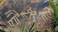
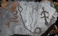
Soon we are at the post of the natural park Saimaluu-Tash, which is located 10 meters south of the highway. Below the container in which the representative office of the park is located, there is a large clearing; an abandoned beekeeper's house is also located here. From here our walk to the petroglyphs will start. Saimaluu-Tash.
Breakfast. Our path lies to the southwest. We pass the beekeeper's house and go down a short road to the left bank of the Kek-Art River, this path is about 1 kilometer. We cross the river on a wooden bridge to the right bank and from here begins a steep ascent to the river terrace.
Soon we are at the top of the terrace, we pass along the trail almost without climbing for about 1.5 kilometers and gradually the descent begins to the right bank of the Saimaluu-Tash River. The Samaluu-Tash River, 6 kilometers long, originates from glaciers located on the northern slope of the Ferghana Range at an altitude of 3635 meters above sea level.
The river is the right tributary of the Kek-Aryk River. We pass to the left bank on the footbridge and move along the river along the path among the thickets of blackcurrant, wild rose, hawthorn. After about 3 kilometers we reach a small stream that flows down a narrow gorge from the eastern slope of the main gorge. Short rest.
We continue to move along the eastern slope of the Saimaluu-Tash gorge, the trail goes up in a serpentine, again we cross a small stream and after about 2 kilometers the trail descends to the river bed, which is under a thick snowfield. Little lower in the riverbed are picturesque snow bridges.
We descend from the slope of the gorge to the snowfield and continue moving up. About 2 kilometers we climb up the snowfield. It should be noted that crossing the snowfield is completely safe. It is necessary to move along the central part of the gorge and not approach the right or left slopes through the snow, where the snow layer may not be reliable and thin.
Soon we reach the place where the gorge bifurcates, the main gorge lies in the south, and from the west, on the left, a tributary flows into the Saimaluu-Tash river. Here we need to move up the main gorge. On the right, a small stream is clearly visible, which flows through a narrow gorge and goes under a snowfield and further into the main Saimaluu-Tash gorge.
From the right slope, a small stream also flows down in this place, the trail passes from the snowfield to the right slope of the gorge. On the slope in this place, where it comes into contact with the snowfield, there are thickets of the Altai bathhouse, rare primrose flowers are found.
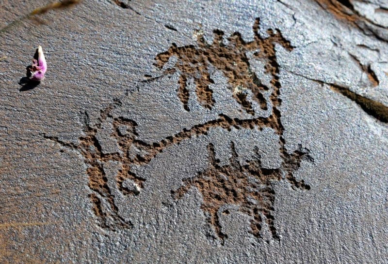
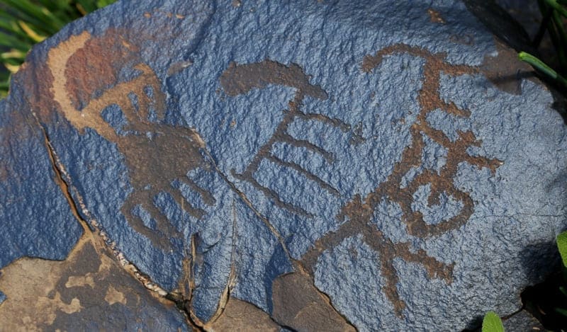
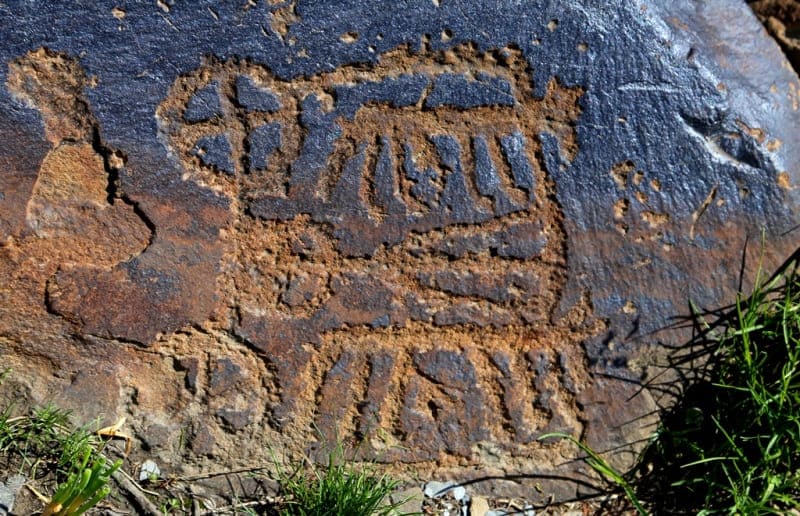
We pass to the right slope and move upwards to the southwest along the onion thickets, soon the slope becomes drier, the steepness decreases and after about 1 kilometer individual rock carvings begin to be found on the boulders. The trail leads to a large clearing in the Saimaluu-Tash valley among small rocks and boulders at an altitude of 3021 meters above sea level.
On the glade itself and to the south, placers of stones covered with patina begin, here in the western part of the Samaluu-Tash tract there are the main sanctuaries of rock paintings. 00 meters south on an ancient moraine, at an altitude of 3,168 meters above sea level, there is a small lake 50 meters long. Walks in the vicinity. Lunch.
Return to the park post (9.5 km). Transfer to Kazarman (35 km), dinner, overnight at the hotel.
Day 4 Transfer: Kazarman - Lake Son-Kol (183 km).
Breakfast. Transfer: Kazarman - Kara-Koo pass - Dudomel village - Kosh-Bulak village - Besh-Kol pass - Kara-Goo pass - Naryn river (126 km). From Kazarman, our path lies east to the Naryn River. Not far from the mouth of the Kurtka River in Naryn, on a natural hill on the right bank of the Naryn River, there was the Kokand Kurtka fortification, which was built in the XIXth century.
Now there are few remnants of swollen, poorly distinguishable fortress walls. 2 kilometers in front of the village of Dzhany-Talap, on the east side of the road, there are the mausoleums of Taylak and Atantai batyrs of the XVIth - XIXth centuries, visiting the mausoleums.
Further transfer: Naryn river - Dzhany-Talap village - Kurtka river - Ak-Terek valley - Moldo-Ashuu pass 3238 meters above sea level (40 km). From the Naryn River, our path lies to the northeast, we gradually climb the Kurtka gorge and further along the Suulu-Kurta gorge located in the Moldo-Too ridge. Ahead of us is one of the most beautiful passes - Moldo-Ashuu, a stop at the pass, a short walk.
Further transfer: Moldo-Ashuu pass - Orus-Bulak valley - Son-Kol lake (17 km).
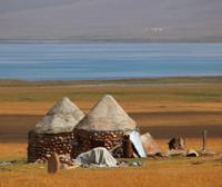
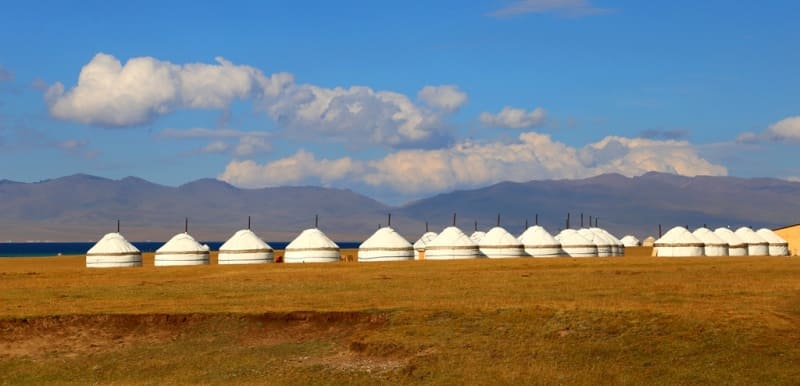
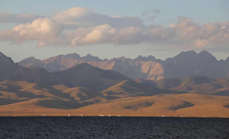
After 4 kilometers we will reach the turn of the road to the left, which leads to the Kara-Keche pass, to the Kara-Keche coal mine and further to the valley of the Dzhumogl River. Arrival at Son-Kul Lake, located at an altitude of 3013.6 meters above sea level, accommodation in a yurt camp, walks by around the lake, dinner, overnight.
Day 5 Breakfast. Lake Son-Kol.
Walks near Son-Kol lake. Lunch, dinner, overnight in yurts.
Day 6 Lake Son-Kel - Bishkek (322 km).
Breakfast. Transfer: Son-Kol lake - Son-Kel river - Bayty-Bulak valley - Kalmak-pass Ashuu with a height of 3446.6 meters above sea level - Tyulek River - village of Sary-Bulak - John-Aryk River - town of Kochkor (126 km).
From Son-Kol Lake, our path lies to the north-west to the town of Kochkor. We pass the Baidulla ridge in which the Kalmak-Ashuu pass is located. From the pass we will descend to the valley of the Tyulek River from the north of which the Karakatty ridge is located.
We pass the small Kengasu mountains, which lie to the west of the Sary-Bulak river, and soon we reach the valley of the John-Aryk river, which leads us to the administrative center of the Kochkor region. Lunch at the cafe. Visiting souvenir shops.
Further transfer: Kochkorka - Orto-Tokoy reservoir - Boom gorge - Kemin town - Tokmok town - Bishkek (196 km).
Arrival in Bishkek. End of the tour.

Note:
Author program of Alexander Petrov. Copying and introduction from the sanction of the author.
Photos by:
Alexander Petrov