


![]()
Вы здесь
Settlement Agashayak.
Ancient settlements of Almaty region.
""I couldn't help but remember that soon after the Great Patriotic War, while traveling around Semirechye, I met an old shepherd who told me that in the Saryesik-Atyrau desert, not far from the shore of Lake Balkhash, he had seen a ruined settlement covered by sand. Inside it was the edge of a bronze cauldron, visible from the ground. It was so large that it could easily hold a camel. (…) A huntsman living on the Saryesik Peninsula had also heard about this settlement… It seemed that the settlement with the bronze cauldron, the most remote in the depths of the desert, had suffered the least from time, and therefore was the most interesting. But no matter how much I looked for it, I couldn't find it."
Pavel Marikovsky. 1991. "Forgotten Islands".
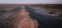
Trip to Agashayak settlement in Saryesik-Atyrau desert.
Agashayak settlement (wooden leg) is located at an altitude of 356 meters above sea level, located 67.7 kilometers to east and slightly north of village of Karaoy, 66.3 kilometers to northeast of village of Bosingen, 118.7 kilometers to west and just south of village of Akzhar, in Balkhash district in north part of Almaty region.
Agashayak ancient settlement is located in the northwestern part of the Saryesik-Atyrau sands, 73 kilometers south and a little east of the Saryesik peninsula on Lake Balkhash, north of the Karkaraly tract, 14.2 kilometers north and a little west of the dune Karakara.
The ancient settlement is located between the dry riverbeds Orta-Bakanas in the east and Shet-Bakanas in the east. The length of the swollen fortification walls is: eastern - 188, western - 180, southern - 181, northern - 188 meters.
Agashayak ancient settlement is located 38.7 kilometers to the south and a little east of Karamergen ancient settlement, Agashayak is 41.6 kilometers north and slightly west of Aktam ancient settlement.
The fortification area is 34047.79 square meters, the perimeter reaches 740.01 meters. In the northern part of the wall, three sagging towers can be traced, which served as the entrance gate to the fortification. There is a legend about the origin of the name of the settlement, which was given to it by Soviet archaeologists.
Agashayak in translation from Kazakh - Wooden leg. It is named after the tract of the same name with a well and a grave, which is located in the south-west of the settlement in 10.8 kilometers from it. At the weather station in the neighborhood (only the ruins of an artesian well remained from it), a disabled observer with such a nickname served, hence the name.
Not far from the ruins of the settlements was the village of Bayauly, now nothing remains of it. Agashayak ancient settlements were surveyed by UNESCO scientists. The cultural layer was studied, soil scientists were present among the participants of the expedition.
The pits were dug, about 2 meters. There are many fragments of dishes on the territory of the ruins. Especially near the pottery workshops. UNESCO staff said they found buckles, clasps, and combs. The ruins of Agashayak belong to the pre-Mongolian period.
There were, apparently, caravanserais that stood on the Silk Road, in the direction of Dzhezkazgan, Central Kazakhstan, on the banks of the Ili River, but later the river retreated from these places to a distance of about 100 kilometers to the west and the caravanserais remained unclaimed.
Remains of caravanserai walls have been preserved. So far, five such monuments have been found, 4 of them are located in the ancient Ili delta. All of them are on the same line at a distance of 25 - 30 kilometers from each other.
Approximately this distance can be covered in a day. It can be assumed that these small fortress cities served as protection for the inhabitants and trade caravans from the raids of warlike tribes.
Geographical coordinates of Agashayak settlement: N45°54'28 E75°39'45
Authority:
"Medieval cities of Kazakhstan on the Great Silk Road". K.M. Baipakov, Almaty, Gylym, 1998, 216 p.
Alexander Petrov.