


![]()
Вы здесь
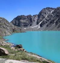
Lake Northern Dzhashyl-Kel.
Lakes in Tien-Shan mountains.
“My work on Asian geography led me to a thorough acquaintance with everything that was known about inner Asia. The most central of the Asian mountain ranges, the Tien Shan, attracted me in particular, on which no European traveler had yet set foot and which was known only from scarce Chinese sources.
To penetrate deep into Asia to the snowy peaks of this unreachable ridge, which the great Humboldt, on the basis of the same meager Chinese information, considered volcanic, and bring him several samples from the fragments of the rocks of this ridge, and home - a rich collection of flora and fauna of a country newly discovered for science - this is what seemed to me the most tempting feat."
"Journey to the Tien Shan." 1856 - 1857 P. P. Semyonov-Tyan-Shansky.
Best places in Tien-Shan mountains.
Flowing, fresh lake North Dzhashyl-Kel is located at an altitude of 3838 meters above sea level, located 6.5 kilometers to east and slightly south of Barskoon pass on southern slope of Terskey Ala-Too ridge in Jety-Oguz district of Issyk-Kul region.
The length of the lake from north to south is 1250 meters, the largest width in the northern part of the lake is 700 meters. The area of the lake is 0.61 square kilometers, the perimeter is 3.42 kilometers. The main filling of the lake basin comes from 4 glaciers located in two gorges on the southern slope of the Terskey Ala-Too ridge.
One of the full-flowing streams flows from the western glacier with a length of 1.7 kilometers, the area of the glacier is 1.22 kilometers, the perimeter is 4.62 kilometers. The upper part of the glacier is located in the crest of the side spur at an altitude of 4614.4 meters above sea level, the tongue of the glacier is located at an altitude of 4061 meters above sea level.
Below the tongue of the glacier, 330 meters away, there is a small moraine lake. A stream flows out of the eastern part of the lake and after 2.3 kilometers flows into the northern part of the Northern Dzhashyl-Kel Lake.
In the southeast of the glacier there is another small moraine lake. The northwestern glacier is quite extensive, its length is 2.3 kilometers, the area of the glacier is 2.53 kilometers, and the perimeter is 7.75 kilometers.
The upper part of the glacier is located in the crest of the side spur at an altitude of 4614.4 meters above sea level, the tongue of the glacier is located at an altitude of 4009 meters above sea level. Below the tongue of the glacier, 370 meters, there is an elongated, moraine lake 430 meters long and 160 meters wide in the northern part.
A stream flows out of the southern part of the moraine lake and after 3 kilometers flows into the northern part of the Northern Dzhashyl-Kel Lake. In the southeast of the glacier there is another small moraine lake.
One of the full-flowing sources that fills the Northern Dzhashyl-Kel Lake is a vast glacier with a length of 3.9 kilometers, which lies 2.5 kilometers to the north of the lake. The glacier completely filled the gorge, in the upper part the width of the glacier reaches almost 2 kilometers.
The area of the glacier is 3.28 kilometers, the perimeter is 10.34 kilometers. The upper part of the glacier is located at an altitude of 4527 meters above sea level, the tongue of the glacier is located at an altitude of 4008 meters above sea level.
A river flows from the southeastern side of the Northern Dzhashyl-Kel Lake, which after 1 km flows into a small moraine, flowing lake. The total length of this river is 7.7 kilometers. The river flowing out of the lake is the left tributary of the Arabel-Su.
In the south of the lake there is a swampy, syrt Arabel valley with numerous lakes.
Geographical coordinates of Northern Dzhashyl-Kel Lake: N41°53'04 E77°46'05
Authority and photos by:
Alexander Petrov.