


![]()
Вы здесь
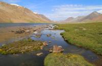
Lake South Dzhashyl-Kel.
Trip to Arabel lakes from Karakol.
"Knowledge increasing,
Strangers visit the edge
I think it's a good thing."
Sebastian Brant.
Sights of Arabel lakes.
The flowing, fresh lake South Dzhashyl-Kel is located at an altitude of 3752 meters above sea level, located 9.3 kilometers southeast of the Barskoon pass in the Arabel valley, between the sulfuric slopes of the Sook ridge and the southern slopes of the Terskey Ala-Too ridge in Jety- Oguz district of Issyk-Kul region.
From the Barskoon pass, the Arabel-Su river flows into the South Dzhashyl-Kel lake, which bypasses the two lakes Western and Central Dzhashyl-Kel. The Arabel-Su River flows 6 kilometers along the swampy Arabel valley from the Central Dzhashyl-Kel Lake to the Southern Dzhashyl-Kel Lake.
The main filling of the lake comes from the Arabel-Su River, which comes from the Central Jashyl-Kel Lake located at an altitude of 3779.1 meters above sea level. Also, the Sarytor River, 9 kilometers long, flows into Lake South Dzhashyl-Kel from the south-west, which originates from the glaciers: Sarytor West and Sarytor East located on the northern slopes of the Sook ridge.
The Sarytor Western glacier, 2.7 kilometers long, is located on the northern slope of the Sook ridge. The area of the glacier is 1.03 square kilometers, the perimeter is 4.91 kilometers. The sources of the glacier are located at an altitude of 4522 meters above sea level, the tongue of the Sarytor East glacier is located at an altitude of 3949 meters above sea level.
The Sarytor river in the upper reaches on the right receives a tributary 2.3 kilometers long, which flows down from the Sook glacier 2.1 kilometers long. The glacier is located to the west of the main Sook gorge. The area of the glacier is 1.24 square kilometers, the perimeter is 5.55 kilometers.
The sources of the glacier are located at an altitude of 4407 meters above sea level, the tongue of the glacier is located at an altitude of 3963 meters above sea level. The Arabel-Su River, 41 kilometers long, flows into the lake from the west, and flows out from the south, which is one of the rivers of the headwaters of the Naryn River.
The length of the South Dzhashyl-Kel Lake from south to north and northeast is 1.5 kilometers, the largest width in the central part of the lake is 700 meters. The area of the lake is 0.56 square kilometers, the perimeter is 4.27 kilometers.
In the south of the lake, 800 meters away, there is an automobile road connecting the syrts of the Inner Tien Shan with the Issyk-Kul basin, and a high-voltage power line. By road, you can get to the Kumtor mine, Petrov Lake and the glacier of the same name.
Geographical coordinates of lake Southern Dzhashyl-Kel: N41°51'17.68" E77°47'19.15"
Authority and photos by
Alexander Petrov.