


![]()
Вы здесь
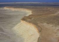
Mountains Karakyz-Kagakyz on Mangyshlak.
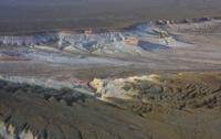
Aktau mountains on Mangyshlak.
"Throughout its entire length, Karatau consists mainly of clay shales, quartzites and sandstones, to which chlorite slate, anthraconite and dolomite are added in places. These strata do not contain any fossils, so it is impossible to judge their age precisely. Judging by the fact that they are unconformably covered by deposits no newer than the Jurassic, one might think that we are dealing here with Paleozoic strata. The Karatau strata are steeply inclined and extend in approximately the same direction as the ridge (W 10° N to W 30° N, less often more) and fall steeply, mainly to the north (40° - 80°), although a southern dip is sometimes observed. The Karatau strata are thus folded into steep folds, the larger ones of which can be demonstrated precisely by this opposite dip, while the smaller ones are sometimes observed entirely (O. from Ausar). In places the Karatau strata are cut by numerous veins of white quartz. According to Barbot's observations, these veins sometimes contain bitter spar, copper green and blue."
Works of Aral-Caspian Expedition. "On geological research in Transcaspian region carried out in 1887." N. I. Andrusov.
Mountains of Kazakhstan.
Karakyz-Kagakyz mountains are located in the central part of Mangyshlak peninsula, 20 kilometers southwest of western part of East Karatau ridge, 13 kilometers south of eastern part of West Karatau ridge, in Mangistau region of region of same name.
The latitudinal Karakyz-Kagakyz mountains stretch for 15 kilometers, their width in the western part reaches 8 kilometers. The mountains on all sides, with the exception of the western side, are more reminiscent of an almost circular cliff of a plateau that rises to the west.
The highest elevation on the Karakyz-Kagyz plateau in the western part is a nameless mountain with a height of 288.6 meters above sea level. The next highest is an unnamed mountain with a height of 283.3 meters above sea level, which is located 3.8 kilometers northwest of the previous mountain.
The Aktau-Beyneu railway runs along the northwestern and northern parts of the mountain. The western valley of the mountains is the Zharyptausken valley, in the south - the Karakyz valley. From the east, the valley of the mountains is the Zhetybai-Shetpe highway and the Kyzylturan valley.
The western part of the cliffs is heavily indented by ravines and is a beautiful tourist attraction, where you can take interesting Sunday walks. The Karakyz-Kagakyz plateau has three terraces - western, central and eastern. The eastern part of the plateau is the most elevated and, in this regard, has dominant heights.
The surface of the mountains has a fairly flat plateau surface. Along the entire perimeter, with the exception of the eastern part, the cliffs are indented by numerous ravines with steep, sometimes sheer slopes.
Geographic coordinates of Karakyz-Kogakyz mountains on Mangyshlak peninsula: N44°02'19 E52°03'35
Authority and photos by
Alexander Petrov.