


![]()
You are here
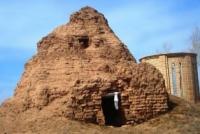
Tomb of saint Kanykey.
Trip to Korgalzhyn district.
“In order to make a story of his own life, everyone adds a little legend to it”
Marcel Zhuando.
Ancient mazars in Akmola region.
Kanykei Mazar is located at an altitude of 328 meters above sea level, located in the northeast of the Teniz-Kurgalzhyn depression, 380 meters northwest of the right bank of the Nura River, 4.4 kilometers north of the village of Orkendeu, 9.6 kilometers southeast of the village of Zhumay, 11.7 kilometers northwest of the village of Korgalzhyn in the Korgalzhyn district of Akmola region.
Mazar Kanykei dates back to the 17th century. The origin of the folk legend is associated with a difficult period in the history of Kazakhstan - the Kazakh-Dzungar wars of the XVIIth - XVIIIth centuries. More than three hundred years ago, the Korgalzhyn area of Orkendeu, literally meaning “development, flourishing,” served as a kind of border between the Kazakhs and Kalmyks, and was often conquered by one or the other.
The 15-year-old daughter of the khan, the beautiful Kanykey, went on one of the military campaigns undertaken by the Kalmyks. However, the Kalmyks, having been defeated by the Kazakhs, were forced to retreat. During the retreat, the galloping horse Kanykey stumbled, and the khan's heiress died.
The girl was buried in the steppe, lining the grave with red brick. Soon the Kazakhs, having liberated their territory, began to settle throughout the free steppe. The noble Bai Otekara settled in the area of Orkendeu with his village.
A few years later, having lost his only son Baybek, Otekar erected a mazar over his grave. The cost of the mazar-monument, estimated at twenty horses, was paid to master Bekbolat. The legend associated with the name Kanykey was so popular among the people that over time the name of Taibek Otekarauly began to be forgotten, and the mazar began to be called “Kanykey”.
Mazar Kanykei was examined in 1979 by employees of the Akmola Regional Museum of History and Local Lore.
Geographic coordinates of Kanykei mazar: N50°37'25 E69°51'55
Authority and photos by:
Local historian Maimukan Boranbai.
https://apgazeta.kz/2018/10/10/sakralnaya-geografiya-mavzolej-uali-xana-mazar-kanykej/
Literature:
General department of the RMK ҒZZhF "Kazaytaқalpyna keltіru", documents of research of cultural monuments and history of the Akmola region. http://srh.kz/content/mazar-kanykey/