


![]()
You are here
Semirechye in Kazakhstan.


 in Almaty. Architect A.P.Zenkov.")


Sights Semirechye and Zhetysu.
“Nature will tell you a direct lie if she can”
Charles Darwin.
Combined Tours in Kazakhstan and Along Central Asia.
In the past strangers-travelers wrote in the diaries and books Kazakhstan is a severe and poor on vegetation land with endless open spaces and huge sandy files. It is because that rarely foreigners did not see the whole Kazakhstan, but only its southern limits adjoining the great deserts of the Central Asia on which the legendary caravan tracked.
And really where these roads ran, there was a little to see for curious wanderers. Unless only barchans and clayey spots or small alternated oases. And as the fantastic legend it was transferred from person to person that on a severe way there is a surprising place where you can see all the landscapes existing on our planet.
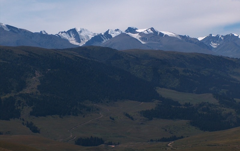
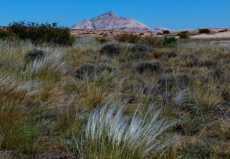
In just 40 - 50 km. the snow-white giant peaks piled up against each other reminding legendary pyramids of the Egyptian pharaons, endless steppe is spread like a huge pale-yellow ocean. Rocky mountain gorges, in which the talkative rivers and rolling falls precipices and rustle with dense bushes, closely adjoin with the drying channels of the ancient rivers that were fallen asleep by the sand.
Ice cold mountain lakes - with cracked deserted plains; the gloomy mountain groves smelling with wood berries - with stuffy woods; cool Alpine meadows - with the dunes and burning hot sand.
And it's not a far-fetched fantastic film; it's our Kazakhstan land, its part glorified by the beauty of Zhetysu.
Today we name Almaty region as Zhetysu, which withholds the whole southeast of the republic. In the north it borders with the Semipalatinsk region with a chain of great lakes: Balkhash, Alakol... In the east there is a border with China, a ridge of the Dzungarian Alatau, in the south there is the most northern spur of the Tian-Shan, in the west we have the Zhambul region.
The territory of the area - 224 000 sq.km., the population - 1.6 million people, average population density - 7 . The climate is continental but at the foothills it is milder. The average temperature in January in a flat part -15, in foothills - 6 degrees, in July 16 and 25 accordingly.
The annual quantity of water on plains is up to 300 mm, in foothills and mountains from 600 up to 1000 mm. In a flat area there're part files of sand, saline soils with wormwood vegetation on brown deserted-steppe soil. Along
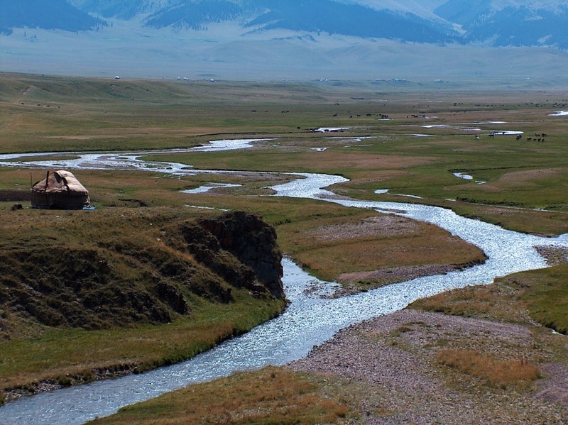
rivers and on the lakes coasts a wood with reed overgrows on meadow-saline soil. In the mountains the high-altitude zones is brightly expressed. The mountain rivers have significant basins. Their sources lay at height over than 3000 m, the basic feed is glacial, but the big influence on their mode is rendered with atmospheric precipitation and underground waters.
River network of the Alatau concerns mainly to the Basin of the Ile River running into Balkhash Lake, and only partially - to the Chu river basin. Balkhash is the third biggest lake in Kazakhstan. Its area is 18000 sq. kilometers, length 614 kilometers, average width - about 30 kilometers.
The deepest place is in the east part -26 meters. In the western part of the lake the Ile River runs taking the third place in the republic by drainage, with the fresh water, whereas in the east part it's salty.
More than 20 kinds of fishes live in Balkhash.
Here you can find perch, bream, and carp. There are many birds' nests on the coast of the lake: uncountable flights of ducks, geese and other water birds. Wild boars are found in cane thickets. In the fortieth years in area of Balkhash valuable fur rodents - musk-rats were lodged.
It is considered, that name the Zhetysu was given after the seven rivers running on its territory (zhety in translation from Kazakh means seven, su - water). However, which rivers should be included into this number?
Undoubtedly, the largest of running into the lake Balkhash, the Ilie river (within the limits of Kazakhstan of 815 km, the general length is 1439 km), Karatal (390 km), Aksu (316 km) and Lepsy (417 km) are.
The others can be the rivers Ajaguz, Tentek and Coksu or Bijon, Sarkand and Baskan can be missing.
Other variants are possible also, as name Zhetysu has a collective character and means concept the "plenty of water". Plenty of the rivers and lakes attracted the mankind to this blessed land since the Stone Age. Especially the traces of Homo sapiens are well seen in the bronze epoch.
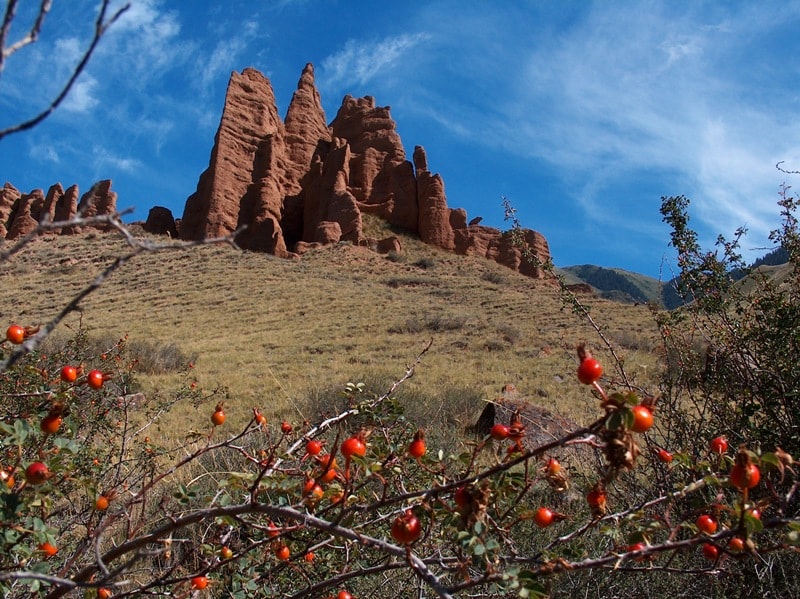
These are the largest petroglyph congestions at the Tamgaly. Here the original variant of the Andron cultures existed. The majority of the settlements were settled down at the banks of the small steppe rivers or the streams, which flew down from the mountains.
There were fields and kitchen gardens. Cattle breeding started to play more essential role in the life of the people. Animals gave food, wool, leather, and bone for hand-made articles, fuel in the form of muck. Meat was a delicacy; it was drunk during the holidays devoted to gods 'sacrifices holidays.
They were perfect cattlemen and they were the first who started the stall maintenance of cattle in the winter. The Scythians took their place. In more detail we shall talk about them later. The tribes in the Zhetysu in the second century ВС were subordinated by the Ussuns who lived here till the third century of our era.
Their settlements and burial grounds were settled in the foothills, mountain valleys, on the rivers banks. Here the dozens of barrows were dug out. As a rule, they represent chains of the barrows extended along a watercourse. The settlements can be found in many mountain gorges.
The Chinese sources characterize these people as nomads. Due to the archeological material it is proved, that the role of agriculture increased from the early period of the Ussuns history to the late one. They ate meat and dairy food, grain baked bread.
Vegetables and fruit grew up in the kitchen gardens and gardens. The Ussuns developed storages of copper, lead, tin, gold and were able to melt iron of which they made knifes, swords, daggers, tips for arrows.
They made beads, rings, and ornaments on cloth with the color stones and precious metals.
The society was not homogeneous but in it there were wealthy people - the nobility, combatants, priests and common people - cattlemen and farmers. In due course proturkic tribes replaced the Ussuns. So 2000 years ago the anthropological type of tribes varies, mongolian features appear.
The turkic tribes formed here the Turkish Kaganat.
One of the main places was the city of Kuntute on the river Ile. Successors of the Turgesh kaganat were the Karluks. Their state existed since 756 up to 940 year. It was a feudal state and it consisted of numerous kin groups.
There was an intensive process of turkiczation of the agricultural inhabitants in the Karluk state which was penetrated by social and class inequality. Alongside with the rich there were the poor but the most deprived of civil rights group was the slaves.
The ruling nobility of nomad tribes owned not only pastures but also the city centers. In the country there were total 25 cities and settlements. However, it did not possess strong economic relations. It was torn apart by intestine wars, struggle for authority and pastures.
In these conditions the real threat came from the Karakhan dynasty. They based here their state. It was not simply a recurrence of former state formations. Military management had been separated from administrative unlike political systems of nomadic societies in the territory of Kazakhstan.
The state-administrative structure was based on the hierarchical principle In the ideology of the nomadic and settled population the ancient turkic religious considerations played an important role. At the same time the Islam accepted as the state religion began to extend.
As a whole the epoch represented qualitatively a new stage in all spheres of a society. Only shocks of the Mongolian invasion interrupted the natural process of the outlined development. The state of the Karakitais was formed here in 1128.
The head of the state had a title "The Gurkhan". Strong discipline was maintained in the army, the system of household taxation was implemented in the country- one dinar was taken from every house. The Gurkhan did not distribute lands to the confidants, as he was afraid of their power and rivalry.
The southern part of the Zhetysu was under their direct management. Part of the Zhetysu to the north from the lie river belonged to the karluk khans; their environment always had a representative of The Gurkhan.
There was a medieval state Ak Orda in the XIV - XV centuries in the Zhetysu. Turkic tribes, who lived in the steppes of Kazakhstan since the sixth century or moved there from the eastern areas during the invasions, occupied it.
In the twenties of the XV century as a result of separation from the White Horde Abulkhair Khan's state was formed - it was the nomadic Uzbecs state. Janibek and Kerei formed the Kazakh state later in 1465 - 1466.
It was divided into three hordes. The territory of Zhetysu was a part of the Senior horde. Till the 30-s' years of the XVIII century the Kazakh state developed independently. But, they couldn't manage alone with the constant and destructive attacks from Jungaria, Nogai horde and the Tatars, thus the Kazakhs had to ask for the help from Russia.
So in 1731 the process of joining to Russia started. The Senior horde joined Russia the latest. To strengthen its power and protect the borders Russia started the construction of the fortresses. Vierney became one of them (1854).
Joining Russia was over only in the middle of the XIX century, being a complex and inconsistent process. At the same time conditions for economic interaction and interaction between nomads and the alien population were ready.
The ground for distribution of literacy, revival of trade and development of relations was pawned. After traveling back through time we return to the period dated of the 6th century ВС, when on the territory of modern Kazakhstan the nomad tribes of the Scythians appeared.
On the 35th km of the Almaty-Narykol road there's a turn sign to Esik city. The distance to it is 8 km. The road goes to the south, to the mountains through the Big Almaty channel. Gradually on its both sides the well-known barrows of the Scythians start to appear.
Here you will feel the real breath of history. There are about 50 burial places, and all barrows have various height and diameter since their size and height depended on a degree of eminence of a person buried.
Authorship:
By the deserved worker of tourism of Republic Kazakhstan, The candidate of pedagogical sciences, the guide - methodologist Lyuterovich Oleg Grigorevich.
Alexander Petrov
photos.