


![]()
You are here
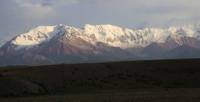
Sarybeles mountains. Naryn region.
Mountain ranges in Aksu valley in Naryn region.
“Our song is burning out,
Like an evening candle
And two constellations hang down
From the saddle shoulder,
And it won't be soon for all of us to fall asleep
And then don't sleep yet,
Who ever saw the mountains -
He will return to them again."
Yuri Vizbor. "Hut". 1962.
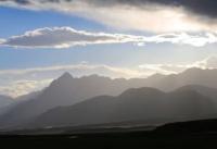
Mountains around Lake Kel-Suu in Kyrgyzstan.
The Sarybeles mountains are located in the western part of the Western Kokshaal-Too ridge in the southeast of the Naryn region. The Sarybeles mountains are located 24 kilometers southwest of the Kekkiya ridge and southwest of the Kel Tau ridge.
The mountains stretch from the south-west from the mouth of the Karabel River to the Tekelik River, to the northeast through the Chon-Sarybeles pass 3590.9 meters above sea level in the vicinity of the cultural center Surashtash to the right bank of the Karadzhilga River - 24 kilometers.
The width of the mountains is 13 kilometers. The western border of the mountains is the valley of the Tekelik River with a length of 52 kilometers. From the south, the borders of the mountains are the Karabel pass with a height of 4023.1 meters above sea level, which is the watershed of the Ortosu rivers from the west and the Western Karabel from the east.
The southeastern border of the mountains is Lake Kel-Suu, located at an altitude of 3530 meters above sea level with a length of 12 kilometers. On the eastern side of Lake Kel-Suu, the Kel Tau Mountains are located.
In the north, the boundaries of the mountains are the Chon-Sarybeles watershed pass 3590.9 meters above sea level, with the sources of the Bolshoi Kuldzhabashi River in the west and the sources of the Chon-Sarybeles River in the east.
The average height of the ridge is 4000 meters above sea level. The highest point of the mountains is the dominant peak, 4726.6 meters above sea level, located in the eastern part of the mountains. In the central part of the mountains there is a peak 4650 meters above sea level.
A glacier descends along the northern slope from the summit, which has two branches. The western branch of the glacier is 3.4 kilometers long, the eastern branch is 2.8 kilometers long. The glacier area is 3.45 square kilometers
A 1-kilometer long glacier descends from the summit 4726.6 meters above sea level to the northeast, which belongs to the basin of Lake Kel-Suu. From the top of 4641 meters above sea level, a glacier with a length of 1.8 kilometers descends to the north.
Gentle watersheds and pre-summit plateaus of Mount Sarybeles are often combined with steep slopes. The southern slope of the ridge is extremely steep and rocky. A characteristic feature of most of the valleys of the Sarybeles mountains is the presence of abrupt transitions of meadow grassy slopes into sheer rocky walls.
On the northwestern slope in the valley of the Kuldzhabashi River, there is the largest glacier No. 33 of the western part of the Sarybeles ridge. The Karovy glacier, valley type, consists of two branches merging in the ablation area.
The area of the right branch is twice as large as the left one. The length of the glacier, determined along the right branch, is 2.8 km, the area is 6.0 square kilometers. In total, 11 glaciers were recorded on the northern slope of the western part of the Sarybeles ridge, of which 3 glaciers belong to the Kelsu river basin No. 28 - 30, 6 glaciers - to the Kuldzhabashi river basin No. 31 - 36 and 2 glaciers - to the Tekelik river basin No. 37 - 38.
The total glaciated area of this slope reaches 22 square kilometers. The eastern part of the Sarybeles ridge is a separate monolithic massif stretching for 7 kilometers from east to west with pronounced peaks. The northern spurs are up to 5 kilometers long.
Here (in the northern part) all, except for No. 22, glaciers of the eastern part of the Sarybeles ridge are concentrated. All glaciers belong to the Kelsu river basin. To the south, the main ridge is cut off by a powerful rock wall.
The nature of the relief and the southern exposure are unfavorable for the development of glaciers, therefore there are no glaciers here. A ridge extends from the main ridge from the west to the south, connecting it with the Kokshaal-Tau ridge.
Mountain-forming rocks are mostly represented by marble and limestone. To a lesser extent - basalts and granites. Along the foot of the slopes of the ridges, quite often there are outlier rocks of a bizarre shape - kekura (Kekur is a pillar or cone-shaped rock of natural origin, usually in rivers, seas or on their banks), as well as individual large stones that have landmark values.
The height of cakes is 10 meters or more, stones are 3 - 5 meters. The bottom of the intermontane valleys is flat or wavy-flat; The main obstacles when driving here are numerous gullies, cliffs of river terraces, as well as areas occupied by rocky placers.
Most of the rest of the valleys in the mountains look like gorges and gorges with steep rocky walls and a narrow bed heaped with stones, sometimes completely occupied by a river stream; movement along such valleys is very difficult, and sometimes impossible.
The soils are almost everywhere dominated by rocky and stony, and only in large intermontane valleys large areas are occupied by crushed stone loams and syrts.
Climate of Sarybeles ridge.
The weather conditions in the region are quite stable and predictable. The driest weather and favorable snow and ice conditions occur in the first half of August. The wind rose determines the offensive of the fronts from the west and northwest.
The climate of the region is sharply continental. The average annual temperature here is minus 5 - 6 degrees, the maximum is +24, and the winter minimum is minus 50 degrees. In summer, at an altitude of more than 3000 meters above sea level, there are frosts every night.
Winter in most of the territory lasts from mid-November to March, inclusive (in large intermontane valleys - from mid-November to mid-March); this season is characterized by cold, mostly cloudy weather. The air temperature in the daytime, depending on the altitude of the area, varies from -3 to -15 degrees, at night - from -20 to -30 degrees (the minimum temperature is about -50 degrees).
Precipitation falls everywhere in the form of snow; the thickness of the snow cover on the lower parts of the mountain slopes and in the intermontane valleys is 1 - 2 meters, high in the mountains 5 - 6 meters, in some places up to 10 meters, in these areas there are frequent snow falls and avalanches.
Geographic coordinates of the Sarybeles ridge: N40 ° 39'47.46 "E76 ° 20'00.77"
Authority and photos by
Alexander Petrov.
http://westra.ru/reports/tianshan/m06shamb3.html