


![]()
You are here
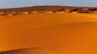
Sands Zhetykonyr.

Excursion trip Kazakhstan.
"Light gives birth to darkness in the desert, dissolves flowers in the desert, makes the soul soar in the sky - so music changes the world!"
Singing Prince.
Drive from Uzbekistan to Kazakhstan.
The Zhetykonyr sand ridge, located at an altitude of 191 to 328 meters above sea level, is located in the northern part of the Betak-Dala desert, 35 kilometers from the left (eastern) bank of the Sarysu River, to the west of the Zhaman-Aybat mountains, 124 kilometers to the south- east of the town of Zhezkazgan, 183 kilometers south-west of the Shalginsky mine, 37 kilometers east of the Kyzylorda - Zhezkazgan highway in the Ulytau district in the southern part of the Karaganda region.
The Zhetykonyr sand ridge (Kaz. Zhetinogyr) stretches from the south-west to the north-east for 155 kilometers, the greatest width of the sands in the southern part reaches 65 kilometers. The border of two districts of the Ulytau and Zhanaarkinsky region runs along the eastern part of the sands.
The southern border of the sands is the Karakoyin salt marsh, which in the spring turns into a vast lake due to melt water. In the north, the ridge borders on the Minshoky hillocks and the Tobylga sands. In the northeastern part of the ridge, there are the Muzkazgan and Kyzylzhol tracts.
In the east, the sands are bordered by the Tuzkol salt marsh and the Kokdombak Upland. The relief of the sand ridge is elevated and hilly. It is composed of Quaternary deposits of the ancient valley of the Sarysu River.
Groundwater is deep. Wheat grass, teresken, wormwood, zhuzgun and others grow on saline soils. Used as a year-round pasture. According to the topography, the boundary of the Zhetykonyr sands is difficult to determine, the sands themselves consist of several sandy areas adjacent to Zhetykonyr.
The southernmost part of the sands is called Karakoyin sands after the name of the Karakoyin salt marsh lake, which serves as the sand border in the south. In the southwest, from south to north, there is a separate ridge of Yanzhal sands in the southern part bordering on the Zhetykonyr sands.
The length of the Yanzhal sand ridge from south to north is 22 kilometers. Between the sands of Karakoyin in the south and the sands of Zhetykonyr proper in the central part of the sand ridge, the sands of Samenkum are located.
12 kilometers to the east it departs from the main sand massif - the Kent sands, which are the eastern end of the sand ridge. In the northwestern part of the sands, the Taldy sand ridge is distinguished, which spreads to the north for 11 kilometers
Along the western part of the ridge, from southwest to northeast, the Zhamanbarsh sands stretch for 23 kilometers, which in their eastern part border on the Zhetykonyr sands. From the north, a narrow 20-kilometer strip is adjacent to the northern border of Zhetykonyr by the Zhideli sands stretching from north to south.
Geographic coordinates of the Zhetykonyr sands: N46 ° 47'42.55 "N46 ° 47'42.55"
Authority and photos:
Alexander Petrov.