


![]()
You are here
Sands of Kyzylkum on of Bukhtarma reservoir.
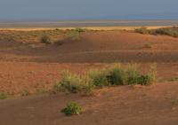
Walk in sands of Kyzylkum on western shore of Bukhtarma reservoir.
"You can't understand the desert by counting grains of sand"
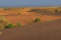
Sands of Kyzylkum in East Kazakhstan region.
The sands of Kyzylkum are located at an average height of 443 meters above sea level, located on the western coast of the Bukhtarma reservoir in the Kokpekty district of the East Kazakhstan region. Those who drove along the Ust-Kamenogorsk-Kurchum road must have paid attention to the hummocky sands behind Kaznakovka before crossing the Bukhtarma reservoir.
These coastal dunes form a real sandy desert with all its attributes: heat, lack of water, lizards and typical desert plants. And although it is far from the famous deserts, its dimensions: the length from south to north is 34 kilometers, the maximum width in the southern part reaches 16 kilometers - it bears the loud name Kyzylkum.
The sand area of Kyzylkum is 312.01 square kilometers. The perimeter of the sands reaches 83.64 kilometers. Even an inexperienced person notices the unusual nature of this corner of nature, and this is truly a unique phenomenon of mutual penetration of different geographical zones.
In our entire region, and perhaps in all of Kazakhstan, you cannot find another such corner where so many elements of the north and south would converge like this at one point. From the deserts of Semirechie such plants as dzhuzgun, chingil, ephedra penetrated here, and from Siberia - pine, creeping juniper, willow.
To the south, Scots pine is no longer found in all of Eurasia, only in the Karkaralinsk region near Karaganda do pine forests also invade far to the south, but still to the north than here, near Zaisan. From a distance, the sands of Kyzylkum look like a huge yellow ridge.
If you drive closer, on the edges of the dunes you notice dark, as if charred edges of the dunes, as if fire had rushed through them, leaving blackened sides. In fact, these are slopes overgrown with a thick carpet of juniper, among which here and there stand lonely and in some places small groups of pines.
These are the remains of the so-called Khatun-Karagai forest, which was noisy here at the beginning of the 19th century and is the southern edge of the pine forests of Kalba. This place is peculiar also because, on the one hand, reed beds of the lower reaches of the Bukoni and Kuludzhuna rivers adjoin it, and on the other, the Bukhtarma reservoir.
Here is the Kuludzhunsky reserve, designed to protect the rich fauna and flora, among which there are many rare waterfowl, and there are also species listed in the Red Book: fat-tailed pygmy jerboa salpingotus, zaisan round-headed lizard, eyed foot-and-mouth disease, etc.
On a sunny summer afternoon, the sands are radiant with heat, and rare pine trees provide almost no shade. Leaving dotted lines of footprints, dark beetles, chained in chitinous shells, run up and down the dunes. Small round-headed lizards with a gray body, as if sprinkled with sand, jump from bush to bush.
- Kick-kick! - the kestrel screeches and, standing in the air, shakes its wings.
Similar to feather grass, selin bushes sway in the wind and draw circles and semicircles on the sand with long-stalk stems. In the evening, when the heat of the day subsides, a low, low, abrupt cry is heard from behind the rosehip bushes.
For a long time, naturalists could not understand who it was: a bird or an animal, and many years passed until the owner of the mysterious voice, the pika, was caught. The night brings freshness and coolness. Small kangaroos - furry-legged jerboas, jumping in an obscure shadow across the sands, clumsily, like a frog, a fat-tailed jerboa jumps.
Gliding in silent flight, they are hunted by a short-eared owl. A male timid roe deer barks in a hoarse and rough voice. All traces of life, as if on clean paper, are drawn on soft sand, which makes it easy to read what happened here, even at night, even during the day.
The first to leave written evidence of pine forests on the left bank of the Irtysh was Lieutenant Genezer, sent by Colonel Springer in 1764 to Zaisan to find places suitable for building fortresses along the Irtysh. Standing in the boat and surveying the area, he noted:
“... At the mouth of the Kurchum on the left bank of the Irtysh, a pine forest is occasionally visible along the sandy hills, which is not very thick.”
In 1830, the fortification of Kokpekty was laid and under it a settlement began to be built up, for which building material was required. Then the felling of nearby forests began: Kaindinskiy and Khatun-Karagayskiy.
In 1849, while conducting geological surveys in the Kalbinsk mountains, mining engineer A. Vlangali wrote:
“At the junction of Talmenka with Bukon, along the sandy hills of the left side of the river, the Khatun-Karagay pine forest extends in several separate groves. Here are the winter quarters of the Karaul-Dzhasyk volost, the wooden hut of its sultan Kulik Chingisov, as well as the Kirghiz mosque. In Khatun-Karagai boron, as well as in Kaindinskiy, parties are sent from Kokpekty to cut timber, and for this purpose a wooden barracks was built here.
The Sultan was tall, slender... His clothes consisted of velvet suitcases, the same jacket and a yargak made of foal skins with wool up."
They tried so hard, chopped, that by the end of the XIXth century, almost nothing was left of boron, and in the XXth century they even forgot about it. In 2002, I visited the Kuludzhun Reserve after more than 30 years of absence.
If once there was a din of birds over the floodplain and geese, waders and gulls flew in flocks, now it is almost quiet here. The willows along the banks are cut down, empty on the Gull Lake and only one consolation is that a young growth of pines has appeared.
But, judging by the growth rate, boron can recover no sooner than in 200 years, and even then, if there is no fire. And how I would like the pine forest to rustle here again, but for this it needs help. One cannot do without artificial afforestation and protection.
Geographical coordinates of Kyzylkum sands: N48°42'09.96" E83°20'47.89"
Authority:
"Essays on the history of the Kazakh Altai". Alexander Lukhtanov.
Photos by
Alexander Petrov.