


![]()
You are here
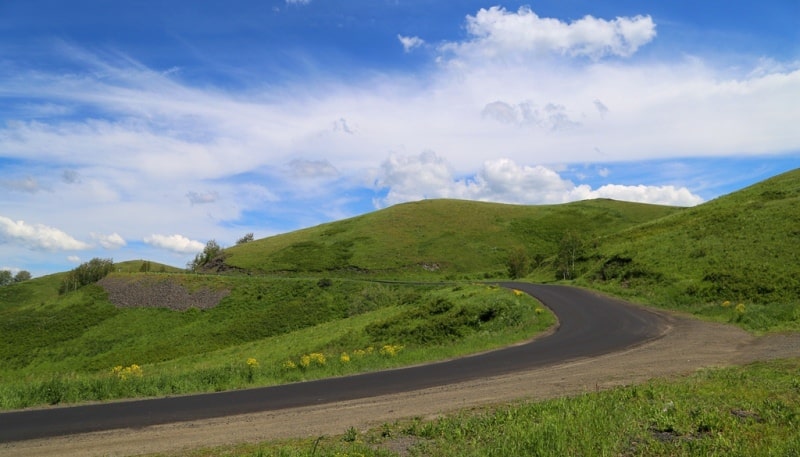
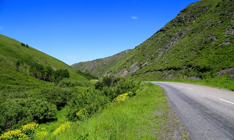
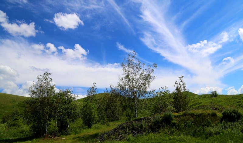
Road Ust-Kamenogorsk - Zyryanovsk.


Trip to Zyryanovsk.
“... The next station is the village of Severny. Drive to it, although insignificant, but a number of passes makes the trip difficult; all the way goes through open mountains; in the valleys there is a fir and aspen forest. Once a meeting with a bear was usual here, but now hunting and forest fires drove him deep into the mountains. A lot of arable land is scattered on the slopes of the mountains”
A. Sedelnikov. "Russia. Full geographical description of our country. ” 1903.
The trip from Ust-Kamenogorsk to Zyryanovsk.
Driving along the Ust-Kamenogorsk-Zyryanovsk highway, hardly anyone thinks about the history of this tract. True, old-timers remember that the road was built in 1940. Then the method of building people was laid the so-called "Eastern Ring".
In fact, it was a reconstruction, expansion with the filling of gravel bed for more modern communication with the calculation of the replacement of horse-drawn vehicles with automobiles. Then, on a voluntary basis, workers and collective farmers from all over the region were mobilized, who, under incredible difficult conditions, almost without any means of mechanization, manually, using shovels and wheelbarrows, sometimes blowing up rocks, carried out excavation works and built bridges.
In hard labor conditions, the road was built in one summer. The state almost did not spend on the purchase of excavators, bulldozers, vehicles. Everything was at the expense of collective farms, due to free, almost slave labor.
Some idea of how the work was organized then can be made from a document identified in the Zyryanovsky branch of the regional archive (funds, inventory 1, file 174), namely, the decision of the Katon-Karagai district executive committee “On the development of the decision of the All-Russian Central Executive Committee and the Council of People's Commissars of the RSFSR of 08/18/1934 years on road construction and laboriousness”, which said:
1. For the free and compulsory participation in road construction, the entire aul-rural population is involved (presumably, the able-bodied - A.L.
§ 13. The following shall be exempt from participation in road construction:
a) workers, office workers and students, persons on active duty, pregnant women after an 8-week period.
b) horses under 4 years of age and camels of 5 years old.
The paved road is still striking in the complexity and picturesqueness of even seasoned motorists. By the richness of vegetation, by the steepness of turns (one “mother tongue” is worth it!) And serpentines, it can be compared with the most famous roads of the Caucasus and Central Asia.
Here is what the Niva magazine, popular in Russia, published in St. Petersburg and intended for inquisitive readers, wrote in 1880 (the volume of the magazine can be judged from the pages of the publication: 504 - 505).
“Mountain passages of the Semipalatinsk region can argue with their distinctive beauty with many European places, which are famous for their picturesqueness. The postal road between Bukhtarma and Ust-Kamenogorsk is especially good.
Here, the Irtysh, having absorbed Bukhtarma, the strongest tributary of the entire upper system, breaks into a narrow gorge, running between vertical rocks, and, just not reaching 5 versts to Ust-Kamenogorsk, again goes to the plane.
Wheel communication on this gorge is unthinkable, and therefore the postal road was laid a few miles from the right bank of the Irtysh. ” It is worth mentioning that it was here, along the Irtysh bank, that a railway was laid, and its tunnels, galleries, and retaining walls speak of its complexity.
“The first 26 versts the road goes along the fast river Ulba, first in a wide green valley, between the gentle hills, but from the 20th verst, going to the left bank of the river (where the bridge now stands near the village of Kamenny Karyer - A. L. .), crossing through which takes place on a fragile ferry, the road enters the highlands, presenting a continuous series of picturesque views.
The mountains, now towering bare cliffs, then rounded up to the top covered with rich alpine vegetation, meadows dotted with peonies, wild left-handed, aconites, beautiful clusters of bushes with sullen fir green, in spring a whole mass of nightingales - all this is a striking contrast to the bare calcined steppe, on which the traveler travels from Omsk to Semipalatinsk.
From the village of Ulba, the road enters the beautiful Prokhodnoe gorge and, gradually rising, climbs up a high ridge, from where an extensive view of the northern Altai and the Zairtysh mountains opens. 12 miles from the village of Severny, the road rises to high Sedelka - the highest pass of the entire road, then abruptly descending into the wild gorge Pikhtovka.”
Honestly, I first learned the name of the pass and gorges that have existed for a long time and managed to forget. Now everyone knows the pass as "Aspen", and now nobody uses the names of the gorges. But the well-aimed and sharp name of especially steep and evil serpentines (once used to say “Babylon”), which the machine hardly fits into, “mother tongues”, firmly stuck.
By the way, the old-timers remember that before 1963 there was a huge growth of gypsum Stalin on the pass. After that, they told for a long time that if you rummaged around in the thick weeds a little to the side, you could find a disgraced generalissimo thrown to the ground.
But we continue the description from "Niva": “The character of the terrain changes from the village of Aleksandrovka: gloomy shale rocks give way to hills, and then granite outcrops in the form of small, detached cliffs are shown with soft outlines, finally, about 10 versts from the Ust-Bukhtarma village, located on the right bank of Bukhtarma, two versts above its confluence with the Irtysh, the road goes to a completely flat valley, sloping down to the Irtysh.
The Ulba Valley, Prokhodnoye Gorge and Pikhtovka Gorge represent the most picturesque views of the entire road, but at the same time the most difficult path. In spring, streams, cluttered with stones, trees and all kinds of rubbish piled from the mountains, leave the banks and, spilling across the bottom of the gorges, wash sand and small pebbles of the roadbed, exposing the rock and large stones.
"The road constantly crosses from one bank to another, along fords far from safe in the flood, and Fir, moreover, is covered with avalanches (" mudflows "in local terms)." Another excerpt from the description of the same road, made in 1903 by A. Sedelnikov in the book “Russia. Full geographical description of our country":
“...The next station is the village of Severny. Drive to it, although insignificant, but a number of passes makes the trip difficult; all the way goes through open mountains; in the valleys there is a fir and aspen forest. Once a meeting with a bear was usual here, but now hunting and forest fires drove him deep into the mountains.
On the slopes of the mountains scattered many arable lands. In front of the station is a high and difficult pass "Cow Saddle". Its slopes are so steep that at first glance it seems unlikely that the horses could drag the tarantass to the top.
The descent is even more difficult, and a rare passenger decides to sit him in the carriage. " And here are the lines that shed light on the history of the road. It turns out that it has existed since the 18th century! Without a doubt, the opening of the Zyryanovsky mine in 1791 played a role in this. G. Spassky, the future publisher of the Siberian Herald magazine, drove along this road in 1809.
In 1829, the great Alexander Humboldt drove here, working all his life to create a "picture of the world." “The duty to maintain this road lies with the Siberian Cossack army, which, in retaliation for this and for its initial construction, back in 1799, was granted the exclusive right to fish on the Irtysh and Lake Zaysan.
This right used to deliver the army up to 15,000 rubles of annual income, but recently the income has decreased to 5,000 rubles, including the cost of salt sold free of charge to the army from Koryakovsky Lake. Since the correction of roads was not carried out by the entire army, but as a natural duty of five villages located along the road, the condition of the road was extremely unsatisfactory.”
And these villages are the same that exist along the road and now: Ulba, Feklistovsky, Severny, Aleksandrovsky and Berezovsky. Next came the villages of Ust-Bukhtarminsk and Talovka (Kondratievo), now flooded, and near them are the modern ones: New Bukhtarma, Oktyabrsky and Pervorossiysky.
As you can see, regarding the maintenance of roads, Soviet power was not original and continued the traditions that existed before it. In tsarist Russia, there was a road duty, when peasants of nearby villages were obliged to maintain and repair the roads assigned to them and to maintain horses and carts for transporting mail and official people.
So, according to the “Economic and Statistical Description of Peasant Volosts of the Altai District for 1882”, the inhabitants of the Zyryanovsk mining factory volost, which included 4 settlements (Zyryanovskoye, Putintsevo, Pikhtovskoye and Bukhtarma), were required to maintain roads to Solovyevo (16 versts), Bogatyrevo ( 16 versts), on Bykovo (14 versts), on Putintsevo (5 versts). In addition, residents of Zyryanovsk were required to keep 5 pairs of horses.
The maintenance of the road from Zyryanovsk to Talovka, as well as 3 transportations via Bukhtarma, lay on the peasants of 11 villages of the Bukhtarma volost (the villages of Snegirevo, Turgusun, Krestovka, Kondratievo, Myakotikha, Parygino, Borodinskoye, Bogatyrevo, Kutikha, Verkh-Myakovyok).
For communication, the inhabitants of these villages were required to keep 5 pairs of horses in Snegirevo, in Kondratievo - 4 pairs, in Solovyevo - 3 pairs. Total underwater duty was 12 pairs.

Authority:
"Essays on the history of the Seven Rivers". Naturalist writer, photo artist, local historian Alexander Lukhtanov.
Photos
Alexander Petrov.