


![]()
You are here
Poduralsky plateau.
A trip to the cities of Kazakhstan.
“I like the dew
Cows of God's miracle on a blade of grass,
The soul is always kind with beauty
I like to watch magical pictures"
Anatoly Bolutenko.
Tours to the Ustyurt plateau in Kazakhstan.
To the south of the valley of Ilek and the Urals, to the west of the Mugodzharsky mountains, there is a vast elevated Podural plateau. In the west, it ends with ledges in the direction of the Caspian basin, and in the south it is separated by the “gulf” of the Aral-Caspian lowland from the northern chinks of the Ustyurt plateau.
Within the plateau, there are almost a basin of the left-bank tributaries of the Urals - Urtaburti, Ileka with Big Khobda and Utva, as well as the upper and middle reaches of the Emba, Sagiza, Uila, Kaldygaita, Buldyrty, and Olenti rivers. In terms of Poduralskoye, or, as it is also called, the Ural-Embinskoye, the plateau looks like a trapezoid with peaks near Uralsk and Aktyubinsk in the north and the border along the Embe river in the south.
The height of the plateau between the rivers gradually increases from 200 m in the west to 350 - 400 m in the east. The wide valleys of the main rivers divide the plateau into separate blocks. Some sections of the interfluve are markedly elevated and form isolated massifs.
Such, for example, the peaks of Baysary 316 meters above sea level, Aktolagay 251 meters above sea level, Mount Imankara 234 meters above sea level on the right bank of the Emba. The peaks of Aktolagay and Imankara are only 120 - 150 km from the Caspian Sea.
Closer to the Urals and Mugodzhars, the fragmentation of the plateau decreases. In the southern half, in depressions, there are numerous depressions (3 - 10 km across), at the bottom of which there are lakes. In the northern half of the lake depressions are few.
he Podural Plateau is composed mainly of Upper Cretaceous sediments, occurring almost horizontally. Four remarkable features can be distinguished in the landscape structure of the plateau. The first is the widespread distribution of Cretaceous mountains, hills, fields with accompanying landforms and tracts.
The second is the presence of the remains of a table top elevated above the plateau-like surface with outcrops of tertiary sandstones covered from above by a glandular sandstone. The third is the development and landscape forming the influence of salt tectonics, a phenomenon associated with the presence at a depth of salt deposits with a thickness of several hundred meters to 1 - 2 km.
Relatively lighter salts float upward, forming salt cushions, domes or whole ramparts. The salt cores of the domes can reach the surface or remain hidden under the overlying rocks. The most active salt domes correspond to relatively high hills. Most often, domes have 15 - 30 km across.
Sometimes they are arranged in groups. Due to the fact that the domes are raised to different heights, some may have only peaks on the day surface, while others may open the salt core. In the center of some domes there are crater-shaped dips filled with water.
The fourth feature of the Ural-Emba interfluve is the originality of the valley-river network of the region. In the era of Caspian transgressions, the sea penetrated far into the plateau along river valleys, leaving marine and delta sediments on wide bottoms.
The ancient rivers carried huge amounts of sand to estuarine sites, which are now found in sand massifs near the valleys of Emba, Sagiz, U silt, Olenta, Buldyrty and Kaldygayty. summarizing the above, Poduralsky plateau can be called a kind of museum of geological and geomorphological natural monuments.
A great variety and diversity are inherent in the soil and vegetation cover of the plateau. Due to the vast extent of the region from the northwest to the southeast, its climate is very heterogeneous. Winter in Podural'e is cold, with little snow, with frequent snowstorms.
The average January temperature is from -12 ° C in the southwest to -16 ° C in the northeast. The height of the snow cover is 20 - 30 cm; completely snowless winters also occur - especially often in the south of the plateau. Spring is friendly and short. Summer is very hot, dry.
The average July temperature rises from 22 ° C in the north to 25 ° C in the south. The average annual rainfall, on the contrary, decreases from 350 to 180 mm. In accordance with the climatic zonality, the Poduralie is divided into two landscape zones: steppe and semi-desert.
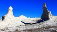
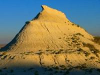
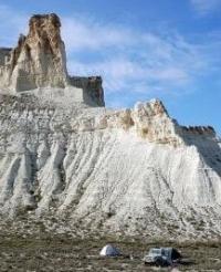
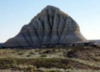
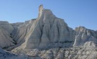
It is no coincidence that we called the Podural Plateau the country of white mountains. In no other region of our country is there such a vast accumulation of Cretaceous outcrops. They form a kind of "chalk" landscapes, which are characterized by the development of karst processes.
Most often, chalky landscapes are separate hills - white mountains - erosive outliers. Failure craters are often found on their slopes. Cretaceous cliffs can sometimes be seen along river valleys and ravines. In some places, Cretaceous deposits, lying close to the surface, serve as parent rocks.
And everywhere, chalk has a decisive influence on the features of modern geomorphological processes, the nature of the soil and vegetation cover, and, ultimately, on the formation of specific natural complexes. In chalk, flint remains of brachiopods, mollusks, sponges, and belemnites are often found.
The uniqueness of the Cretaceous landscapes is best reflected by the characteristic Cretaceous vegetation. Several local species are listed in the Red Book of the USSR. Among them, Cretaceous chamomile - Trotsky's navel with large yellow flowers, it is common in the northern chalk massifs of the plateau.
The vegetation of Cretaceous landscapes is a favorite object for the study of botanists. This is due to the fact that many plants are endemic or relict; knowing their origin, one can trace the history of the formation of local flora and establish the age of modern landscapes.
Among the Cretaceous remnants of Podural'e, the most interesting, with a rich and diverse Cretaceous flora, can be distinguished. The westernmost group of Cretaceous monuments is formed by outliers in the Shalkar basin.
Mount Santas rises on the northern shore of this lake, surrounded by a typical Tyrsov-fescue steppe .. On the chalky slopes there are thickets of Cretaceous ñ Trotsky’s umbilical cord, Meyer’s insect, and salt-loving Kermeka plants, salt marshes and others grow wildly on the saline plumes.
In the upper reaches of the Shalkar tributaries Sholakankaty and Isen, the chalk cliffs of Dzherentau and Akkuduksai are interesting. The large chalk massif Ishkargantau, up to 263 m high, is located on the right bank of the middle course of the Utva River in the Ural Region.
Two chalk massifs in Khobdinsky district of Aktobe region should be distinguished as natural monuments. One of them, Mount Shangrow, is located 15 km west of the village of Akrab, on the left bank of the Big Khobda. The other, Mount Itas, or Zhantyztau, is located 13 km south-west of the village of Novon in the upper reaches of the Kiil River.
Of great interest are the Akshatau hills, stretching for 20 km from north to south along the right bank of the Wila. Thickets sprawled at the foot of the mountains. Thorny capers occupy an island position on Akshatau, which is almost 600 km from the main range.
They remained here from the landscapes of the time when the Aral-Caspian deserts extended to the foothills of the Southern Urals. Close to the border of the Aktobe and Atrau regions, on the right bank of the Emba River, the chalk massif Aktolagay reaches a height of 251 m.
Here, as well as on Akshatau, capers are prickly. In the extreme south-west, the Podural plateau extends far into the Caspian lowland by the Cretaceous islands of Imankara, Koykara, Kuttertas, Akkergeshen, Saryniaz, and Kizilkul ridges.
The Koikar massif 154 meters above sea level is the southernmost remnant of the Cretaceous plateau. This is an isolated hill, consisting of several ridges. Ural botanists registered 234 species of chalk plants on the massifs of Aktolagay, Imankara and Koikara.
The characteristic landscape features of the Cretaceous mountains are extremely sparse cover and amazing diversity of the composition of herbs. The white chalk surface, reflecting the sun's rays, heats much weaker than dark-colored soils, as a result a special microclimate is formed here.
Unforgettable tours of the chalk slides of the Ural-Emba region. Everything is unusual here: the blinding snowy whiteness of the slopes, and the inexorably scorching sun, and fancifully flattened chalky vegetation with modest and delicate, or with catchy flowers, and the unusual polished karst bas-relief of the chalk walls, and the fossilized remains of ancient marine animals.
An indescribable feeling of contemplation of extraterrestrial nature encompasses a person who first set foot on these snow-white ridges.
Authority:
A.A. Chibilev. "The Ural River." Leningrad. Hydrometeoizdat, 1987.
Photos
Alexander Petrov.