


![]()
You are here
Koshkarbay valley.
Archaeological excavations in Kasakhstan.
"But there is no East and there is no West,
What is tribe, homeland, clan,
If the strong with the strong face to face
Stands at the edge of the earth?"
"The Ballad of East and West." R. Kipling.
Archaeological sights in Kazakhstan.
The Koshkarbay valley is located at an altitude of 285 to 456.4 meters above sea level, in the interfluve of Shagalaly (Chaglinka) and Koshkarbay, located between the villages of Karsak and Aidarly in the Zerenda district of the Akmola region.
More than seventy monuments of the primitive era are concentrated here in a relatively small area. Archaeological research carried out here in 2005 - 2008 by the Kokshetau archaeological expedition led by V.F. Seibert made it possible to establish that this territory was inhabited by humans already in the Mesolithic era, i.e. about 10,000 years ago.
The abundance of archaeological sites of different times (from the Mesolithic to the Middle Ages) speaks of the dynamic historical past of the population, which left behind numerous temporary sites, year-round settlements, mounds and ground burial grounds and single burial structures.
This area has long attracted the attention of many researchers. Starting from the 50s of the XXth century, archaeological exploration and stationary work was carried out here under the leadership of K. A. Akishev (1960), G. B. Zdanovich (1974), M. K. Khabdulina (1974) , W. F. Seibert (1984).
Excavations were carried out at the burial ground of Koshkarbay I, the settlements of Kenotkel VIII, IX, X, the settlement and burial ground of Pavlovka, the site of Kenotkel XXI, etc. The attractiveness of the Kenotkel archaeological region for ancient people was that here, in a relatively small space, beautiful natural environmental conditions.
Everything here was conducive to fishing, hunting and gathering. The valley was protected from harsh winds; the rich forest vegetation on the hills and along them served as a resource for the construction of dwellings, burial structures and bonfires.
And even epochal climate changes towards continentality during the Eneolithic did not affect the numbers and habitual way of life of the local inhabitants. The attractiveness of the region in the light of archeology lies in the fact that the objects are located compactly in relation to each other, and their study makes it possible to create a fractional periodization of the Stone, Bronze and Iron Ages, to reconstruct the subtleties of economic and production activities, to model the economic and cultural type characteristic of the Koksheau region .
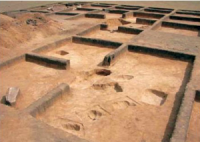
The bulk of information about the life of primitive people is given to us by burials that have survived to this day. The Koshkarbay I burial ground, located on the hill of the right bank of the Shagalaly River, is divided into four groups of burials and includes more than seventy grave structures.
Seven burials were excavated here, each of which consists of a stone box and a grave structure in the form of a stone ring-fence or other forms. The high density of their location and the presence of these structures suggests that this is not only a resting place, but also a site where various cults, including funeral ones, could be performed.
This is confirmed by the ruins of ceramic vessels and animal bones discovered here - traces of funeral funeral feasts. Human bones are recorded in graves pits at a depth of 30 cm and continued to occur to a depth of 80 cm, i.e., right up to the mainland.
In addition to these remains and animal bones, bronze mirrors with handles, bronze rings and needles, a bronze object that can tentatively be described as a ritual knife, beads from shells, jewelry made of gold foil on a bronze base, collapsed ceramic vessels, and solid clay products were found in the burial grounds. and other items.
In all the graves there are larger or smaller layers of coal and ash - evidence of sacrifices. The materials from these burials are characteristic of the Fedorov culture. Approximately the same composition of artifacts was obtained by archaeologists at the Kenotkel XVIII and Kenotkel XIX burial grounds on the right bank of the Koshkarbay River.
Kenotkel XIX consists of 37 burial structures, the design of which is represented by several types. These are earthen embankments lined with stone slabs at the base. Stone displays outline the embankments in the form of a circle, a figure of eight, or a figure of eight with an extension.
These are mounds with earthen embankments. In 2007, one of the mound structures was excavated here. To obtain maximum information about the monument, archaeologists used the method of continuous dissection with squares 4 × 4 meters.
The opening was carried out with horizons of 10 - 20 cm. Soon, in the southern part of the pit in one of the enclosures, a vessel, an accumulation of human bones, and about a dozen paste beads were discovered. Fragments of four vessels also lay here.
On the western side, at a depth of 50 – 60 cm, a bronze open bracelet with spiral curls at the ends, a fragment of a bronze earring, three bronze pendants in the shape of crosses and other similar finds were found.
Very interesting information was obtained by archaeologists during excavations of the Kenotkel XVIII burial ground. The burial “Pit No. 1” was a ground pit, where there was a trapezoidal wooden frame with one, possibly two crowns, i.e., instead of stone, wood was used here.
The grave was covered with wooden blocks, the ends of which rested on the edges of the pit. At the bottom of it were placed two human feet with decorations made of bronze and paste sewn onto a base of organic origin.
The feet were placed separately, at opposite ends of the grave. Then the hole, without filling it with soil, was covered with blocks made of coniferous wood, probably pine, which rows on the hills near the burial ground.
On top of the block were placed parts of the skeleton of the buried person, dismembered and in a non-anatomical order. Along with the remains of the deceased, fragments of ceramics from several vessels were placed.
The design of “Pit No. 1” included another fence; here, at the bottom of the log house, an infant child was buried, to whom, as accompanying equipment, he was given ceramic vessel-jar and three asyks are placed.
Then the grave pit, without being filled with soil, was covered with a wooden flooring made of wide blocks. A large jar was placed on top of the block and soil was poured into it, in which the whole and crushed bones of another deceased were buried, as well as the bones of an animal, accompanied by fragments of ceramics.
The similarity of the funeral rites and funeral structures at the Kenotkel burial grounds of the XVIIIth and XIXth centuries indicates that they belonged to the same population group that lived in the Koshkarbay tract in the XVth – XIIth centuries. BC e.
Geographic coordinates of Kashkarbay valley: N53°03'13.62" E69°00'22.15"
Authority and photos by:
Atlas “From Altai to the Caspian Sea”. Volume 1.
http://lib.yessenovfoundation.org/atlas-tom-1/files/assets/basic-html/page227.html