


![]()
You are here
Koshkarbai burial ground.
Ancient burial grounds in Akmola region.
“Look at the world.
How to unravel all the secrets of nature?
The more you look, the more confusion grows.
And in the essence of the sun, and the ray, and the atom in the ray
Partially, maybe my mind will find its way.
But how can I comprehend my coming into the world, and how can I comprehend my departure?..”
Turkic medieval Sufi poet Alisher Navoi.
Monuments of Bronze Age in Zerenda region.
The Koshkarbay burial ground is located at an altitude of 280 meters above sea level, located in the interfluve of Chaglinka and Kashkarbayki, 105 meters from the left bank of the Kashkarbayka River, 857 meters northeast of the village of Kenotkel, 1.2 kilometers south and slightly east of the burial ground Kenotkel, 4.8 kilometers northwest of the village of Kashkarbay in the Zerendinsky district of the Akmola region.
The Koshkarbay burial ground is located in a valley formed by the Chaglinka and Koshkarbayka rivers. The burial ground is located within the Koshkarbai hill. The burial ground consists of approximately 50 grave structures (the exact number is impossible to determine, since some of them were destroyed, others were excavated).
It consists of rectangular, round, stone fences and earthen mounds surrounded by rings. On the territory of the monument, two stone women were found standing near structures of Turkic times and a fallen menhir about 3 meters long.
The burial structures in the southwestern part of the burial ground date back to the Turkic period and the Bronze Age. During archaeological work in the area, archaeologists examined 6 archaeological monuments of the Koshkarbay-1 burial ground in 2014.
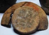
30 bronze items (beads, animal fangs, shells in the form of amulets, etc.) and 8 ceramic vessels were found. A burial was discovered on mound No. 5 near the village of Kenotkel on the heights of the Chaglinka River at a depth of 50 cm.
The human skeleton was in the fetal position - laid on the right side, legs bent at the knees, head pressed into the chest. At a depth of 45 cm, three ceramic Andronovo vessels with Aryan square symbols were found. As a result, the region has always attracted the attention of archaeologists.
Since the creation of the Archaeological Map of Kazakhstan (1956), archaeological exploration teams have been regularly working here: Akishev (1956), Seibert (1987, 2006). Stationary excavations are also carried out: Koshkarbay I burial ground (1973), Kenotkel VIII, IX, X settlement (1978 -1979), Pavlovka settlement and burial ground (1983, 2005), Kenotkel XXI site (2005 G.).
Geographic coordinates of Kashkarbay burial ground: N53°03'53.74" E69°00'28.25"
Note:
If you are using geographic coordinates for Google Earth or Google Maps navigation systems, you must remove the last two digits from geographic coordinates and " (hundredths of a second) and enter the result in the input line. Example: N51°44'09.67" E72°39'40.81" = N51°44'09 E72°39'40
Authority:
https://history-akmola.kz/ru/kieli_obektileri/qr93.html
Photos by:
Vasiliy Bubnov
https://vk.com/wall-3073135_104279?z=photo15220006_349374763%2Fwall-3073135_104279