


![]()
You are here
Kenotkel burial ground.
Archaeological expeditions of Kazakhstan.
“A nomad goes through life like dust.
No one wants to know his name, no one knows how much his grief weighs."
Song of the nomads.
North Kazakhstan archaeological expedition.
The Kenotkel burial ground is located at an altitude of 278 meters above sea level, located 80 meters from the right bank of the Shagalaly (Chaglinka) River, 1.8 kilometers north and slightly east of the village of Kenotkel, 3.5 kilometers south and slightly west of the village of Pavlovka , 5.9 kilometers northwest of the village of Kashkarbay in the Zerendinsky district of the Akmola region.
Discovered and examined by exploration teams of the North Kazakhstan Archaeological Expedition in 1988 (leader A.G. Shalagin), examined in 1992 (leader S.O. Miller), in 2006 by a detachment of the Karaganda Archaeological Expedition (leader V.F. Seibert).
The burial ground consists of burials of various types: a mound paved with stone, 12 meters in diameter, 0.1 meters high, a stone ring fence with a diameter of 4 meters, a double ring fence: the outer one is 10 meters in diameter, the inner one, shifted to the north, is 3 meters.
15 mounds with a mound of earth and stone, 6 - 8 meters in diameter, up to 0.3 meters in height. In the center of some of them there are gaps with a diameter of 0.5 - 2 meters and a depth of 0.3 meters. 16 mounds with an earthen embankment with a diameter of 3 - 10 meters, a height of 0.3 meters and three mounds with a diameter of 10 meters, a height of up to 0.5 meters with an earthen embankment and a stone ring fence at the base.
In the northern part of the burial ground there was an earthen mound with a diameter of 10 meters along the outer ring fence and 4.5 meters along the inner ring, excavated in 1992. The outer stone fence of the mound was destroyed by plowing.
In the given and north-eastern parts of the fence, vertically installed slabs have been preserved in places. In the center of the fence, the outlines of a grave pit of a subrectangular shape with rounded corners, oriented along the line of glen corners, oriented along the line west - northwest - east - southeast are recorded.
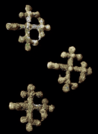
At a depth of 65 cm, the dimensions of the hole were 1.6 × 1.02 meters. Along its walls, the remains of a wooden frame were found, on which blocks with a diameter of up to 20 cm were laid. At a depth of 80 cm and at the bottom of the pit 105 cm deep, individual fragments of ceramics, bronze beads, earrings, clasps, fragments of vessels were collected, and also discovered fragments of a human skull and ribs.
The vessel is pot-shaped, well fired, the walls are dense, the dough is mixed with sand. The ornament is in the form of drawn lines of shaded rhombuses along the neck of the vessel, depressed triangles along the shoulder, in the upper part of the body there are drawn simple meanders, the bottom part of the vessel is without ornament.
The findings allow us to attribute the burial to the Alakul culture of the XVIIIth - XVIth centuries BC. e. In 2007, a mound was excavated in the western part of the burial ground. Beneath it, two ring-shaped fences made of vertically placed stone slabs were discovered.
The funeral structures and burial rites in them turned out to be similar to the materials from the 1992 excavations and the Kenotkel 18 burial ground. Ceramic vessels and decorations found in the burials date back to the XVth - XVIIth centuries BC. e.
The monument characterizes the funeral rite and the history of the settlement of the tribes of Northern Kazakhstan in the Bronze Age.
Geographic coordinates of Kenotkel burial ground: N53°04'31.77" E69°00'08.19"
Note:
If you are using geographic coordinates for Google Earth or Google Maps navigation systems, you must remove the last two digits from geographic coordinates and " (hundredths of a second) and enter the result in the input line. Example: N51°44'09.67" E72°39'40.81" = N51°44'09 E72°39'40
Authority:
https://cyclowiki.org/wiki/%D0%9C%D0%BE%D0%B3%D0%B8%D0%BB%D1%8C%D0%BD%D0%B8%D0%BA_%D0%9A%
Photos by:
Atlas “From Altai to the Caspian Sea”. Volume 1.
http://lib.yessenovfoundation.org/atlas-tom-1/files/assets/basic-html/page227.html