


![]()
You are here
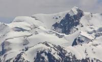
Jirganaktu Glacier in Kokshaal-Too Range.
Valley glaciers of northern slope of Kakshaal-Too Range.
“The Kokshaal-Tau Range is the most powerful of all the ranges of the Central Tien Shan. The Kyrgyz call it the “Great Tien Shan”. In the west, it joins the Alay Range in Fergana, and in the east - even further east of the Khan-Tengri node - it ends within China. This eastern part remains almost unexplored to this day.
“Central Tien-Shan”. A. Letavet. 1937.
A trip from Naryn to Eastern Aksai Valley.
Valley glacier Jirganaktu No. 84: the upper boundary of glacier is located at an altitude of: from 4841 to 5102 meters above sea level, tongue of glacier is located at an altitude of 3938 meters above sea level, is located in western part of Kyzyl-Asker mountain range, on northern slope of western part of Kakshaal-Too ridge in Atbashi district of Naryn region.
Valley glacier Jirganaktu No. 84 is one of the characteristic glaciers of the western part of the Kyzyl-Asker mountain range, this glacier is part of the majestic mountain landscape of the Inner Tien-Shan, where powerful peaks and ice fields form a harsh and at the same time fascinating picture of the highlands.
The length of the Jirganaktu glacier. No. 84 is 6.9 kilometers, the area reaches 16.7 square kilometers, the perimeter is 29.25 kilometers, the greatest width in the upper part reaches 4.1 kilometers. To the west of the glacier is the Ak-Baital glacier No. 87, 5.5 kilometers long, to the east is the Kyzyl-Asker glacier No. 80, 9.2 kilometers long.
The river of the same name flows from the glacier, 17 kilometers long, merging with the Karagermes River to form the beginning of the Eastern Aksai.
Geographical position and morphology of Jirganaktu glacier.
The upper boundary of the glacier begins at the foot of three significant peaks:
- Krakow - 4841 meters above sea level,
- Uygur - 4979 meters above sea level,
- and the Moon Rib - 5102 meters above sea level.
From under the snow and ice slopes of these peaks, the Jirganaktu glacier flows down the mountain valley, forming a long tongue that reaches 3938 meters above sea level. This position defines it as a typical valley glacier: it forms in high-mountain cirques and continues to move along an elongated valley, gradually narrowing and losing mass.
Climate and natural features in the valley of the Jirganaktu glacier. The Kakshaal-Too ridge area has a sharply continental climate with long, harsh winters and short, cool summers. Most of the annual precipitation falls in solid form, which contributes to the active feeding of glaciers.
The snow line here passes at an altitude of about 4000 - 4500 meters above sea level, so the Jirganaktu glacier remains stable, fed by constant snowfalls. The tongue of the glacier is subject to seasonal changes: in summer, part of the ice melts, forming streams and small flows that feed the river system of the Jirganaktu and Eastern Aksai river basins.
Scientific and natural significance of Jirganaktu glacier.
The Jirganaktu glacier is of interest to glaciologists, as it is one of the indicators of climate change in the Inner Tien-Shan. Observations of the dynamics of its tongue, the thickness of the ice and the rate of melting allow scientists to judge the trends in global warming.
In addition, the glacier has an important hydrological significance: it serves as a source of fresh water for the rivers that originate in the area of the Kyzyl-Asker mountain-ice massif.
For travelers about Jarganaktu glacier.
The path to the Jirganaktu glacier is not just a hike, but a real journey into the world of eternal snows and icy expanses of Kokshaal-Too. The road starts from the valley of the Eastern Aksai and gradually takes the traveler up the gorges, along the transparent mountain rivers.
The higher you climb, the more dramatically the landscape changes: green pastures are replaced by rock scree, and then the harsh world of snowy peaks opens up. Ice fields, bordered by rocky peaks, make a strong impression on researchers and rare travelers who have managed to see this corner of the Tien-Shan.
The main reward for those who decide to climb here is the opportunity to see three famous peaks at once:
Krakow (4841 m),
Uygur (4979 m),
Lunar Rib (5102 m).
They rise like guards above the glacier, protecting it from the winds and uninvited guests. At an altitude of almost 4,000 meters, the tongue of the glacier amazes with its power: it is a stream of frozen time, where cracks and ice grottoes play in the sun's rays with shades of blue and emerald.
The air here is clear and fresh, and in the silence you can hear only the crackling of ice and the noise of the wind coming from the passes. For climbers, this place is a challenge and a dream, for nature lovers - a rare opportunity to touch the world where mountains, snow and ice reign.
Legend of "Moon Rib" peak.
Since ancient times, the Kyrgyz nomads who roamed at the foot of Kakshaal-Too told mysterious stories about peaks hidden in icy clouds. A special place among them was occupied by the Moon Rib peak. They said that in ancient times, a wise woman healer lived in these places, who knew the power of herbs, water and stone.
All the nomads respected her because she helped the sick and saved travelers who had lost their way in the mountains. But one day, during a severe winter snowstorm, she disappeared in the snow and never returned. People believed that the moon itself had descended to the earth and taken her to itself, giving her eternal peace among the mountain ranges.
Since then, one of the peaks began to glow silver on moonlit nights. Its slopes and sharp ridges, covered with snow, reflect the cold light so brightly that they resemble a bone rib cutting through the sky. People called the mountain "Moon Rib" - in honor of the woman who went to the moon, and in memory of the fact that the light of the night star will always show the way to those who are lost in the mountains.
Even today, travelers who spend the night at the Jirganaktu glacier say that in clear weather the peak seems to come alive, and its radiance becomes a guiding star for all travelers.
Geographical coordinates of Jirganaktu glacier No. 84: N41°01'46 E77°16'23
Authority and photos by:
Alexander Petrov.