


![]()
You are here
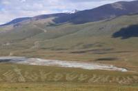
Eastern Aksai River.
Eastern Aksai River Basin.
“I managed to find out from the horseman riding with me about the passes to Aksai, I spotted them and decided to go to Aksai along the Kyny Pass; then I left the road and rode along the very cliffs of the river bank. Here I soon came across a gentle slope, clearly marked on the coastal cliff, here almost vertical; beyond the slope there was again a flat area, still about one hundred and fifty or two hundred feet higher than the river.”
“Travel through Turkestan Region and Exploration of Mountainous Country of Tien-Shan.” N. Severtsov. 1873.
Eastern Aksai Tributaries.
Eastern Aksai River is 44 kilometers long and is formed by confluence of Kentor, Karagermes, and Bolgandybel rivers, which originate on northern slopes of western part of Kokshaal-Too ridge and belong to Kyzyl-Asker mountain-glacial massif. River is one of components of Kokshaal River and flows through territory of At-Bashinsky district of Naryn region.
Geographic coordinates of Eastern Aksai River: N41°07'12 E76°55'47
Right tributaries that form Eastern Aksai River.
Kyzylunet River.
Kyzylunet River is 22 kilometers long and originates from the Komarov glaciers: Western, Central, and Eastern. The sources of the river are located at an altitude of 4086 meters above sea level, the mouth of the river is at an altitude of 3670 m. a. s. l.
Several small tributaries flow downstream of the Kyzylunet River from the southern slopes of the Dzhanydzher Range. At the 15th kilometer from the beginning of the sources, the riverbed widens to 2 kilometers
Geographical coordinates of Kyzylunet River: N41°09'56 E77 22'50
Kogalyachap River.
To the north of the Kyzylunet River is the Kogalyachap River bed, 3.4 kilometers long, which originates from small lakes and marshy areas located on the plateau of the same name. The Kogalyachap River is a right tributary of the Kyzylunet River.
It should be noted that in high water or during prolonged rains, the Kotur River, in the southern part of the Kogalyachap Plateau, flows into the Kogalyachap River bed. The Kogalyachap plateau serves as a watershed on the northern slope of the western part of the Kakshaal-Too ridge for the basin of the Uzengegush and Eastern Aksai (Mudyuryum) rivers.
Several tributaries flowing from the southern slopes of the Dzhanydzher ridge flow into the Kogalyachap River on the right. The river's sources are located at an altitude of 3,791 m. a. s. l., the mouth of the river is at an altitude of 3,740 m. a. s. l.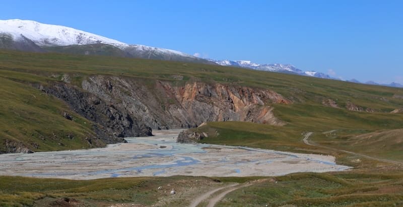
Geographic coordinates of Kogalyachap River: N41°11'23 E77°22'29
Mustyr River.
The Mustyr River, 10.5 kilometers long, originates from a small glacier located on the southern slope of the Dzhanydzher ridge. At 5.9 kilometers from the beginning of the sources on the right bank there is an abandoned outpost of the Naryn border detachment.
The river's source is located at an altitude of 4084 m. a. s. l., the mouth of the river is at an altitude of 3683 m. a. s. l. From the mouth of the Mustyr River, there is a car route to Lake Bivachnoye, 11 kilometers long, in the vicinity of which base camps for climbers are established for climbing the peaks in the Kyzyl-Asker mountain range.
Geographic coordinates of Mustyr River: N41°12'33 E77°14'53
Karagermes River.
After the confluence of two rivers: Kyzylunet and Kyzyl-Asker, the Karagermes River is formed, 8 kilometers long. The source of the river is located at an altitude of 3670 m. a. s. l., the mouth of the river is at an altitude of 3508 m. a. s. l.
Geographic coordinates of Karagermes River: N41°08'57 E77°12'04
Left tributaries that form Eastern Aksay River.
Kentor River.
Kentor River is 5 kilometers long and is formed by the confluence of the Jirnagaktu and Bolgandy Rivers. The river's sources are located at an altitude of 3,597 meters above sea level, the mouth of the river is at an altitude of 3,510 m. a. s. l.
Geographic coordinates of Kentor River: N41°07'41 E77°11'31
Jirnagaktu River
The Jirnagaktu River, 11.5 kilometers long, originates from the glacier of the same name, 6.9 kilometers long, which is located on the northern slope of the western part of the Kakshaal-Too ridge. The river's sources are located at an altitude of 3,943 m. a. s. l., the mouth of the river is at an altitude of 3,597 m. a. s. l.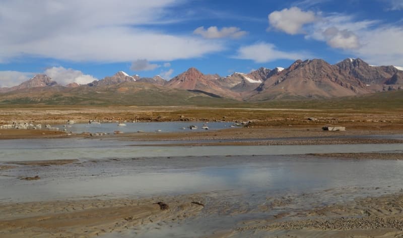
Geographic coordinates of river Dzharnagaktu: N41°06'10 E77°16'07
Bolgandy River.
Main channel of the Bolgandy River is formed at an altitude of 3734 m. a. s. l. with a length of 8.8 kilometers. After 5 kilometers from the beginning of the sources, on the right, the river receives a tributary of the Bolgandy Zapadny with a length of 2.9 kilometers.
The sources of the Bolgandy River are located at an altitude of 3994 m. a. s. l., the mouth of the river is at an altitude of 3598 m. a. s. l. The Bolgandy River originates from the eponymous glacier No. 88 with a length of 5.3 kilometers, which is located on the northern slope of the western part of the Kakshaal-Too ridge.
Geographical coordinates of Bolgandy River: N41°05'28 E77°13'31
Bolgandybel River.
Bolgandybel River with a length of 11.9 kilometers is formed from the confluence of the small rivers Chochirganak and Bolgandybel. The river's source is located at an altitude of 3943 m. a. s. l., the mouth of the river is at an altitude of 3597 m. a. s. l.
Geographic coordinates of Balgandybel River: N41°07'21 E77°10'11
Chochirganak River.
The Chochirganak originates from the glacier of the same name, 3 kilometers long, which is located on the northern slope of the western part of the Kakshaal-Too ridge. The river's source is located at an altitude of 4018 m. a. s. l., the mouth of the river is at an altitude of 3803 m. a. s. l.
Geographic coordinates of Chochirganak River: N41°02'32 E77°09'41
Left tributaries of Eastern Aksay River.
Teshikchan River.
The Teshikchan River, 12.2 kilometers long, originates from small glaciers located on the northern slope of the Kokshaal-Too ridge. The river's sources are located at an altitude of 4116 m. a. s. l., the mouth of the river is at an altitude of 3490 m. a. s. l..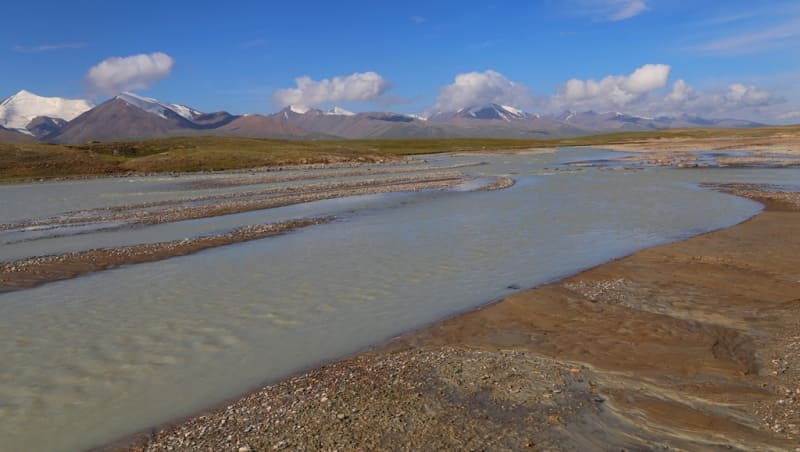
Geographic coordinates of Teshikchan River: N41°07'25 E77°03'44
Dzhamanichke River.
The main channel of the Dzhamnichke River is formed at an altitude of 3364 m. a. s. l.l from two main tributaries originating on the northern slopes of the Kokshaal-Too ridge. The length of the river is 13.7 kilometers is a left tributary of the Eastern Aksai River.
At the 16th kilometer from the beginning of the sources, the riverbed widens to kilometers. The sources of the river are located at an altitude of 3983 m. a. s. l., the mouth of the river is at an altitude of 3296 m. a. s. l. Dzhamnichke has 6 tributaries on the left. 2.2 kilometers before the confluence, the river receives an unnamed tributary from the left, 6.2 kilometers long.
In the upper reaches of this tributary is located moraine, flowing, fresh lake Dzhamnichke. The length of the lake is 445 meters, the greatest width in the eastern part reaches 353 meters, the area of the lake is 0.11 kilometers, the length of the coastline is 1.3 kilometers.
The lake is located on the northern slope of the western part of the Kakshaal-Too ridge.
Geographical coordinates of Lake Dzhamanichke: N41°01'55 E76°52'11
Geographical coordinates of Dzhamanichke River: N41°04'46 E76°52'32
Maly Kogart River.
Maly Kogart River, 13.2 kilometers long, originates from small glaciers located on the northern slope of the Kokshaal-Too ridge and is a left tributary of the Eastern Aksai River. The river's sources are located at an altitude of 4015 m. a. s. l., the mouth of the river is at an altitude of 3232 m. a. s. l.
Geographic coordinates of Maly Kogart River: N41°04'22 E76°47'35
Kogart River.
Kogart River, 21.8 kilometers long, originates from small glaciers located on the northern slope of the Kokshaal-Too ridge and is a left tributary of the Eastern Aksai River. The river's sources are located at an altitude of 4107 m. a. s. l., the mouth of the river is at an altitude of 3217 m. a. s. l.
On the right, the river has one tributary, on the left, 10 small and large tributaries.
Geographic coordinates of Kogart River: N41°03'46 E76°44'36
Right tributaries of Eastern Aksay River.
Korumdu-Su River.
The main channel of the Korumdu-Su River is formed at an altitude of 3714 m. a. s. l. The length of the river is 17.5 kilometers. After 5.1 kilometers from the beginning of the sources, the river receives a tributary from the left orumdu-Su Zapadny, 6 kilometers long.
The sources of the river are on the southern slope of the Bel-Su Pass located at an altitude of 4147 m. a. s. l., in the main ridge of the Dzhanydzher Range. The mouth of the river is at an altitude of 3428 m. a. s. l.
Geographical coordinates of Korumdu-Su River: N41°10'41 E77°05'19
Ak-Baital South River.
Ak-Baital South River is 15 kilometers long and is a right tributary of the Eastern Aksai River. The river originates on the southern slope of the Ak-Baital Pass, located at an altitude of 3668 m. a. s. l., in the main ridge of the Dzhanydzher Range. The mouth of the river is at an altitude of 3380 m. a. s. l.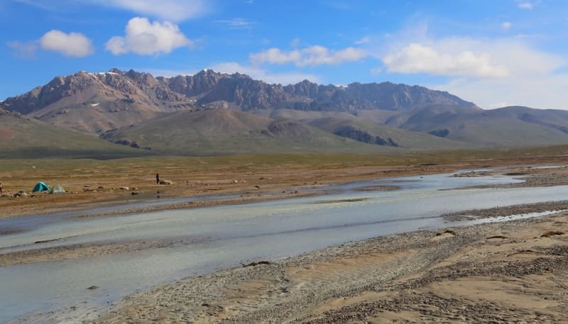
Geographical coordinates of Ak-Baital South River: N41°10'41 E77°05'19
Kensu River.
Kensu River, 17.9 kilometers long, originates on the southern slope of the Dzhanydzher Range and is a right tributary of the Eastern Aksai River. The river has 6 tributaries on the left and right. The river originates at an altitude of 4455 m. a. s. l., in the main ridge of the Dzhanydzher Range.
The mouth of the river is at an altitude of 3352 m. a. s. l. In the upper reaches of the river there is a pass of the same name at an altitude of 4025 m. a. s. l., through which a trail is laid that connects the parallel valley of Dzhaljir with the valley of the Eastern Aksai.
Geographic coordinates of Kensu River: N41°10'59 E76 56'12
Belbulak River.
Belbulak River, 11.6 kilometers long, originates on the southern slope of the Dzhanydzher ridge, is a right tributary of the Eastern Aksai River. The river has no tributaries. The sources of the river are at an altitude of 4347 m. a. s. l. The mouth of the river is at an altitude of 3286 m. a. s. l.
Geographic coordinates of Belbulak River: N41°08'15 E76°53'44
Bash Kashkasu River.
Bash Kashkasu River, 13.2 kilometers long, originates on the southern slope of the Dzhanydzher ridge and is a right tributary of the Eastern Aksai River. The river has one tributary on the left and two on the right. The river's sources are at an altitude of 4112 m. a. s. l. The mouth of the river is at an altitude of 3285 m. a. s. l.
Geographic coordinates of Bash Kashkasu River: N41°08'10 E76°51'25
Orto-Kashkasu River.
Orto-Kashkasu River, 12.9 kilometers long, originates on the southern slope of the Dzhanydzher ridge and is a right tributary of the Eastern Aksai River. In its upper reaches, the river is formed by two tributaries: the right tributary originates from the southern slope of the Dzhilanach Pass, located at an altitude of 4008 m. a. s. l. in the main Dzhanydzher ridge.
1.3 kilometers to the southwest of the pass is the Orto-Kashkasu peak, 4451.2 meters above sea level. The left tributary originates from the southern slope of the pass of the same name, located at an altitude of 4042.1 m. a. s. l. in the main ridge of Dzhanydzher, 3 kilometers from the beginning of the sources the river forms the main channel.
The mouth of the river is at an altitude of 3263 m. a. s. l. 450 meters from the mouth on the right bank of the river is the border outpost of the Naryn border detachment.
Geographic coordinates of Orto-Kashkasu River: N41°07'16 E76°47'52
Kashkasu River.
The Kashkasu River, 16 kilometers long, originates on the southern slope of the Dzhanydzher ridge, is a right tributary of the Eastern Aksai River. The river has one tributary on the left and one on the right. The river originates from the southern slope of two passes: Kashkasu at 3970.3 m. a. s. l. and an unnamed pass at 4015.4 meters above sea level.
The mouth of the river is at 3215 m. a. s. l.
Geographic coordinates of Kashkasu River: N41°06'40 E76°43'56
Authority and photos by:
Alexander Petrov.