


![]()
You are here
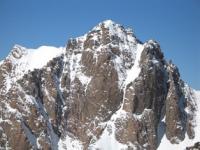
Glaciers of North-Alichur Range.
Coach tour in Dushanbe.
“Travel makes a man free”
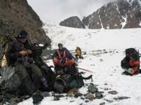
Side trip in Tajikistan.
The North Alichur Ridge has a length of 110 kilometers and an average height of 5200 meters above sea level. The highest heights in the western part of the ridge are Langar peak, 5580 meters above sea level. To the east, the ridge ridge goes down.
The northern slope is a complex system of ridges, spurs, the height of which is not inferior to the height of the main ridge, and sometimes exceeds it. These are the Irkht Mountains, 5330 meters above sea level, the Karadzhilga ridge, 5800 meters above sea level.
Sarez mountains, 5580 meters above sea level and others. Along the northern slope, Lake Sarez stretched for 57 kilometers. For the southern slope and the axial part of the ridge, the relief is characteristic of the Eastern Pamirs.
The area of glaciation of the North Alichur Ridge reaches 294.7 square kilometers. There are 468 glaciers. Almost all glaciation is located on the northern slope of the ridge and its spurs - 402 glaciers with an area of 273.9 square kilometers.
Varieties of caravan glaciers prevail, especially in the eastern part of the ridge and in the marginal parts of the spurs. Glaciers in mostly small. The area of the largest complex valley glacier in the headwaters of the Kattaarjanay River is 7.1 kilometers square.
On the southern slope of the North Alichur Ridge, there are only 66 glaciers with an area of 20.8 square kilometers. Glaciers are only in the western part of the ridge on the slopes of ancient cars in the headwaters of wide trough valleys.
These are shallow valley and slope glaciers. All but two are smaller than 1 kilometer square. The South Alichur Ridge is the eastern continuation of the Shahdara Ridge. It stretches from west to east from Matz Pass to the Istyk River.
The mountain ridge of the main watershed is slightly dissected and is characterized by gentle rounded peaks. The average height of the ridge in the western part is 5050 meters above sea level, in the eastern 5100 meters above sea level, the average height of the firn line is 5030 meters above sea level on the southern slope and 5050 meters above sea level on the northern.
There are 256 glaciers on the South Alichur ridge with a total area of 72.1 square kilometers. The glaciers are small (none exceeds 3 square kilometers), they are fairly evenly distributed along the main ridge of the ridge and its spurs.
On the southern slope of the South Alichur Range, there is 41 glacier with an area of 11.2 square kilometers. All glaciers are less than 1 square kilometers. These are mainly hanging and caravans, located mainly in shaded places.
The glaciation range is only 100 - 500 meters. The main glaciation is concentrated on the northern slope of the South Alichursky ridge 10 glaciers have an area of 1 to 3 square kilometers, there are valley and caravan glaciers (about 50% of the total glaciation area) with short parts ending above 4660 meters above sea level, but the most numerous are small slopes glaciers (51% of the total).
The surface of the glaciers of the South Alichur ridge is characterized by the widespread development of penitents.
The total area of glaciation of the North Alichur Range is about 158 square kilometers.
The largest glaciers in the North Alichur Range.
Glacier 312 with a length of 7.0 kilometers, an area of 5.8 square kilometers, located at an altitude of 4290 to 5650 meters above sea level, belongs to the basin of the tributary of the Akzhilga River.
Glacier 165 with a length of 5.1 kilometers, an area of 7.1 square kilometers, located at an altitude of 4640 to 5590 meters above sea level, belongs to the Chulak-Teke river basin.
Glacier 431 with a length of 5.1 kilometers, an area of 4.7 square kilometers, located at an altitude of 4700 to 5700 meters above sea level, belongs to the basin, a tributary of the Alice River.
Glacier 342 with a length of 5.1 kilometers, an area of 4.2 square kilometers, located at an altitude of 4750 to 5760 meters above sea level, belongs to the Akjilga Vostochnaya basin.
Glacier 170 with a length of 4.9 kilometers, an area of 5.1 square kilometers, located at an altitude of 4730 to 5400 meters above sea level, belongs to the basin of a tributary of the Karadzhilga River.
Glacier 100 with a length of 4.9 kilometers, an area of 5.1 square kilometers, located at an altitude of 4740 to 5450 meters above sea level, belongs to the tributary of the Ramaif River.
Glacier 430 with a length of 4.7 kilometers, an area of 3.1 square kilometers, located at an altitude of 4810 to 5600 meters above sea level, belongs to the basin, a tributary of the Alice River.
Glacier 306 with a length of 4.6 kilometers, an area of 2.5 square kilometers, located at an altitude of 4450 to 5600 meters above sea level, belongs to the basin of the tributary of the Alice River.
Glacier 356 with a length of 4.5 kilometers, an area of 3.8 square kilometers, located at an altitude of 4450 to 5780 meters above sea level, belongs to the Bazardara River Basin.
Glacier 83 with a length of 4.4 kilometers, an area of 5.9 square kilometers, located at an altitude of 4680 to 5300 meters above sea level, belongs to the basin of the tributary of the Ramaif River.
Glacier 317 is 4.4 kilometers long, 3.4 square kilometers in area, located at an altitude of 4700 to 5780 meters above sea level, belongs to the Akjilga River Basin.
Glacier 93 with a length of 4.2 kilometers, an area of 3.2 square kilometers, located at an altitude of 4730 to 5340 meters above sea level, belongs to the basin of the tributary of the Ramaif River.
Glacier 169 with a length of 4.0 kilometers, an area of 2.8 square kilometers, located at an altitude of 4740 to 5520 meters above sea level, belongs to the basin of the tributary of the Kaoajilga River.
Authority:
"Glaciers." L.D. Dolgushin, G.B. Osipova. Series "Nature of the world." Moscow, the publishing house "Thought". 1989.