


![]()
You are here
Glaciers of Muzkol Range.
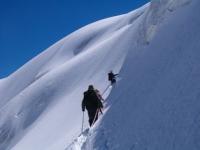
Traveling in mountains of Muzkol Range.
“How could we go for a few days to the wilderness without supplies of either fodder or provisions! What was with us was not enough for the return trip from Alai: we were starving for two days. "
A.P. Fedchenko.
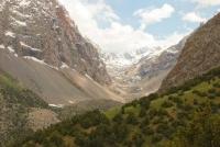
Sights of Muzkol Range.
The Muzkol ridge stretches in a latitudinal direction for 136 kilometers from the confluence of the Kudary and Murgab rivers in the west to the meridional section of the South Akbaital river valley in the east. It is partly located in the Rushan and Shugnan regions, for the most part the ridge is located in the Murghab region of the Gorno-Badakhshan Autonomous Region of Tajikistan.
This is one of the largest glaciation sites in the Eastern Pamirs. There are 441 glaciers, their total area 328.7 square kilometers. According to the relief and the nature of glaciation, two independent sections are distinguished - western and eastern, separated by the Akbulak pass.
The western section is a section of the Muzkol ridge about 50 kilometers long between the Kokuybel river in the north and Sarez lake in the south. Its average height is 5370 meters above sea level, the height of the firn line is 5000 meters above sea level.
There are 74 glaciers on this section of the ridge with a total area of 55.9 square kilometers. On the southern slope, steeply terminating towards Lake Sarez, there are 13 glaciers with an area of 5.2 square kilometers.
These are caravan and small valley glaciers with small feeding areas and narrow parts of glaciers buried under streams of rubble, leaving under the lake level. On the northern, more gentle and wide slope 61 glacier with an area of 50.7 square kilometers.
Buried Glacier Ends they go down to 4800 - 4900 meters above sea level, and only the largest glacier - Azyktash (11.0 kilometers long, 8.5 kilometers square) ends at an altitude of 3860 meters above sea level. 75% of the total number of glaciers and 23% of the area of glaciation on the slope are attributed to shallow and glacier ice.
The eastern section of the Muzkol ridge in the form of islands of snow-capped peaks rises above the wide valleys and drainage basins of the Eastern Pamirs. This section of the ridge is higher than the western one (average height is 5720 meters above sea level, the highest point is the peak of Soviet Officers with a height of 6200 meters above sea level and has a complex orography.
Powerful spurs - the Northern Zortashkol ridges, up to 6100 meters above the level - go north from the main watershed. of the sea and Zortashkol, up to 6000 meters above sea level.On the eastern section of the Muzkol ridge, there are 267 glaciers with a total area of 272.8 square kilometers.
The vast majority of glaciers are located on the northern slope of the Muzkol ridge and on its northern spurs. not the Bozbaital River, at the junction the Muzkol and Zortashkol ranges, the largest glacier of the Muzkol ridge is located - the glacier of Soviet Officers (7.8 kilometers long, 13.6 kilometers square) with an extensive feeding area and a short clean end of the glacier.
On the southern slope of the Muzkol ridge there are 105 glaciers with an area of 57.7 square kilometers. Small hanging and caravans predominate, there are several small valley glaciers. To the south of the Muzkol ridge there is an elongated latitudinally Pshart ridge up to 5570 meters above sea level.
There are 26 glaciers with an area of 6.9 kilometers square. On the Muzkol ridge and its spurs and on the Pshart ridge, the firn line lies at an altitude of 5200 - 5300 meters above sea level, the ends of the glaciers descend to 4400 - 4800 meters above sea level.
The total area of modern glaciation is 376 square kilometers.
The largest glaciers of the Muzkol ridge.
The Azik-Tash glacier, with a length of 11.0 kilometers, an area of 7.5 square kilometers, located at an altitude of 3860 to 5600 meters above sea level, belongs to the basin of the Kokuybel river tributary.
Glacier 446 with a length of 9.2 kilometers, an area of 9.2 square kilometers, located at an altitude of 4,500 to 5,000 meters above sea level, belongs to the basin of a tributary of the Zortashkol River.
Glacier 568 with a length of 8.7 kilometers, an area of 6.4 square kilometers, located at an altitude of 4060 to 5870 meters above sea level, belongs to the Kayukbekdzhilga river basin.
Glacier 453 with a length of 8.2 kilometers, an area of 9.7 square kilometers, located at an altitude of 4420 to 6140 meters above sea level, belongs to the basin of the tributary of the Zortashkol River.
The Glacier of Soviet Officers with a length of 7.8 kilometers, an area of 13.1 square kilometers, located at an altitude of 4520 to 6233 meters above sea level, belongs to the Bozbaital river basin.
Glacier 449 with a length of 7.0 kilometers, an area of 8.2 square kilometers, located at an altitude of 4480 to 6070 meters above sea level, belongs to the basin of a tributary of the Zortashkol River.
Glacier 581 with a length of 6.5 kilometers, an area of 4.2 square kilometers, located at an altitude of 4000 to 5560 meters above sea level, belongs to the basin of a tributary of the Usoitdara River.
The 6.1 km long Sauksai Glacier, an area of 3.1 square kilometers, is located at an altitude of 4650 to 6000 meters above sea level, belongs to the Sauksai River Basin.
6.0 km Zortashkol Glacier, an area of 8.2 square kilometers, located at an altitude of 4640 to 5700 meters above sea level, belongs to the Zortashkol River Basin
Glacier 471 with a length of 5.9 kilometers, an area of 5.8 square kilometers, located at an altitude of 4400 to 5900 meters above sea level, belongs to the basin of the tributary of the Zortashkol River.
Glacier 565 with a length of 5.5 kilometers, an area of 2.1 square kilometers, located at an altitude of 4160 to 6070 meters above sea level, belongs to the basin of the tributary of the Zortashkol River.
The Akbaital glacier is 4.6 kilometers long, 5.5 square kilometers in area, located at an altitude of 4750 to 5920 meters above sea level, belongs to the Akbaital river basin.
The Aidemge Glacier with a length of 5.1 kilometers, an area of 4.7 square kilometers, located at an altitude of 4620 to 5700 meters above sea level, belongs to the basin of the Bozbaytal River tributary.
Authority:
"Glaciers." L.D. Dolgushin, G.B. Osipova. Series "Nature of the world." Moscow, the publishing house "Thought". 1989.