


![]()
You are here
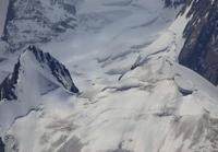
Glaciers Dzhangart-Tynbashi.
Gorge tour Kyrgyzstan.
“When in the spring sometimes
They want to wander their feet,
Enough dust on the old road
On a forgotten path in Marlborough.
This path is not repaired,
Who goes there now?
Like the path of life
It curls somehow...?
It's just a direction
Mapping the path.
It's just an opportunity
Go and go"
G. Thoreau.
Walking to glaciers in Kyrgyzstan.
Dzhangart-Tynbashi group of glaciers is located on northwestern slope of Kokshaal-Too ridge, in upper reaches and sources of Dzhangar River, in area between Kyyche and Dzhangart rivers, in Dzhety-Oguz region in south of Issyk-Kul region.
In the west, the glaciers border the valley of the Kayche River, located from north to south, and are the westernmost sources of the Dzhangart River.
Glacier Dzhangart-Tynbashi Eastern.
The area of the glacier is 9.06 square kilometers, the perimeter of the glacier is 23.3 kilometers. The length of the glacier is 8.7 kilometers. The glacier is located on the northern slope of the Kokshaal-Too ridge, its sources are in the main ridge at an altitude of 5060 meters above sea level.
Geographic coordinates of Dzhangart-Tynbashi Eastern glacier: N41°38'44 E78°53'48
Dzhangart-Tynbashi Glacier Central.
The area of the glacier is 16.91 square kilometers, the perimeter of the glacier is 22.84 kilometers. The length of the glacier is 8.1 kilometers.The glacier is located on the northern slope of the Kokshaal-Too ridge; its sources are located in the main ridge at an altitude of 5048 meters above sea level.
Geographic coordinates of Dzhangart-Tynbashi Central glacier: N41°37'49 E78°52'04
Glacier Dzhangart-Tynbashi Western.
The area of the glacier is 5.51 square kilometers, the perimeter of the glacier is 16.26 kilometers. The length of the glacier is 5.51 kilometers. The glacier is located on the northern slope of the Kokshaal-Too ridge; its sources are located in the main ridge at an altitude of 4977 meters above sea level.
To the west of the Dzhangart-Tynbashi Western glacier is the Dzhangart Pass, 4181.7 meters above sea level, through which in Soviet times geologists built a survey and technological road. In the northern part, the glacier is strongly torn by transverse cracks.
The Dzhangart-Tynbashi Western glacier in the northern part ends in a vast, moraine lake 1.06 kilometers long; the greatest width of the lake in the central part is 440 meters. The area of the lake reaches 0.38 square kilometers, the length of the coastline is 2.73 kilometers. The tongue of the glacier ends in a semicircle into the lake. The lake is located in the depression of the moraine part of the glacier.
Geographic coordinates of Dzhangart-Tynbashi Western glacier: N41°40'07 E78°49'37
Authority and photos by:
Alexander Petrov.