


![]()
You are here
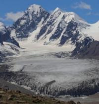
Glaciers of Bordu-Tor.
Travel along Kyrgyzstan.
It’s bad to linger around the same fire for a long time: your eyes get tired of looking at the same thing, your ears become deaf. We have to go. The turbidity does not stick in fast water..."
Ulukitkan. "Death will wait for me." Grigory Fedoseev.
Expedition tours in Kyrgyzstan.
Bordu-Tor glaciers are located at an altitude: upper limit of glaciers is from 4745 to 5402 meters, end of glaciers is 3796, 3894 and 3875 m. a. s. l., located on northern slope of Kuilyu ridge, in gorge of same name, in Ak-Suu region in southeast of Issyk -Kul region.
The Bordu-Tor glaciers belong to the Saryjaz River basin.
Bordu-Tor East Glacier.
The area of the glacier is 1.59 square kilometers, the perimeter of the glacier reaches 4.87 kilometers. The length of the glacier is 1.75 kilometers. The upper boundary of the glacier is located at an altitude of 4745 m. a. s. l. The end of the glacier is located at an altitude of 3875 m. a. s. l.
Geographic coordinates of Bordu-Tor East glacier: N42°05'19 E78°45'18
Bordu-Tor Central glacier.
The area of the glacier is 4.88 square kilometers, the perimeter of the glacier reaches 12.87 kilometers. The length of the glacier is 3.73 kilometers. The upper boundary of the glacier is located at an altitude of 5402 m. a. s. l.
The end of the glacier is located at an altitude of 3894 m. a. s. l.
Geographic coordinates of Bordu Tor Central glacier: N42°03'43 E78°45'59
Glacier Bordu-Tor Western.
The area of the glacier is 4.47 square kilometers, the perimeter of the glacier reaches 11.04 kilometers. The length of the glacier is 4.29 kilometers. The upper boundary of the glacier is located at altitudes of 5020 and 4870 m. a. s. l.
The end of the glacier is located at an altitude of 3796 m. a. s. l.
Geographic coordinates of Bordu Tor Western glacier: N42°04'48 E78°48'35
The Bordu-Tor River, 7.8 kilometers long, flows from the glaciers, which is the right tributary of the Kuylyu River. In the upper reaches, at an altitude of 3268 m. a. s. l., the river forms the main channel of two tributaries. The river receives its sources from three Bordu Tor glaciers: Eastern, Central and Western, located on the northern slope of the Kuilyu ridge, in the gorge of the same name.
The river receives its main source from the Bordu-Tor Central glacier. After 4 kilometers, a tributary adjoins on the left, which flows from the Bordu-Tor Vostochny glacier with a length of 1.7 kilometers. After 5.5 kilometers, a tributary will flow in on the right, which originates from the Bordu-Tor West glacier with a length of 3.7 kilometers.
Geographic coordinates of Bordu Tor River: N42°06'44 E78°46'28
Authority and photos by:
Alexander Petrov.