


![]()
You are here
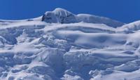
Glacier Karasai North.
Go on a journey in Kyrgyzstan.
"The southern slopes hide warmth,
Keeps snow from accumulating
But the playful stream drifted into the shade
And he managed to cover himself a little with ice.
The distant slope is losing clouds.
They blow away and expose the rocks,
Slightly encouraged by the rays,
But eternity kept tired.»
Victor Storopov.
Short trip in Kyrgyzstan.
The largest glacier of the Central Tien Shan Karasai North is located at an altitude of 4665 to 3798.8 meters above sea level, located on the western slope of the Akshiyrak ridge in the Jetyoguz district of the Issyk-Kul region.
The length of the glacier is 9 kilometers, the area reaches 19.65 square kilometers, the perimeter of the glacier is 41.03 kilometers. The upper part of the glacier is located at an altitude of 4665 meters above sea level. The tongue of the glacier is located at an altitude of 3798.8 meters above sea level.
500 meters below the tongue of the glacier, at an altitude of 3790 meters above sea level, there is a moraine, flowing lake Karasai. The length of the lake is 1.9 kilometers, the largest width in the central part reaches 480 meters.
The area of Lake Karasai is 0.97 square kilometers, the perimeter of the lake is 5.83 kilometers. In the southwestern part, the lake is blocked by a natural moraine dam. Below the lake there are also more than 16 small moraine lakes.
The Karasai River flows out of the southeastern part of the lake and is 57 kilometers long. The Karasai river basin consists of the following rivers: right tributaries - Kyrkoo-Su, Kyrgakkor, Kyrkol, Kundai, Achiktashtor, Tarasu, left tributaries - Egiztor, Ashu-Su, Kentor, Cholkotor, Sarytor.
Geographic coordinates of Karasai Severny Glacier: N41°49'05.71" E78°14'49.33"
Authority and photos by
Alexander Petrov.