


![]()
You are here
Glacier of Fedchenko.
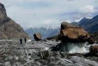

Tours on Fedchenko Glacier.
“I dedicated it to the memory of Alexei Pavlovich Fedchenko. I wanted to express this, although to a weak degree, my deep respect for the wonderful works of my unforgettable comrade, to whom we owe an explanation of so many dark questions in the geography and natural history of Central Asia. I wanted his name to remain forever connected with one of the grandiose glaciers of the Central Asian highlands - I wanted this because the study of glacial phenomena especially interested Alexei Pavlovich. Let, in the distant future, the Fedchenko Glacier remind travelers the name of one of the gifted and zealous explorers of Central Asia!”
Vasily Fedorovich Oshanin.
Glaciers of Pamirs.
Fedchenko Glacier was discovered and named in 1878 by V.F. Oshanin, but he could not see the entire glacier and fully appreciate its size.
This was done by the topographer I. G. Dorofeev, who compiled in 1928 the first map of the glacier and the surrounding area. Fedchenko Glacier is the largest glacier in the Pamirs. Located in the territory of Central Tajikistan in the Gorno-Badakhshan Autonomous Region.
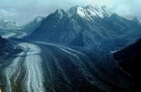
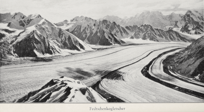
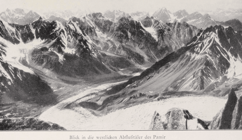
Belongs to the mountain-valley type of glaciers. It is the longest glacier in the world outside the polar regions. The area of the glacier is about 700 sq. km. Among Eurasian glaciers, the Fedchenko Glacier is second only to the Karakoram Glaciers of Siachen and Baltoro.
A long and straight glacier originates in a circus at an altitude of 6,200 m. a. s. l., formed by the northern slopes of the Paris Commune peak, 26 Baku Commissars peak and the northwestern slope of Independence Peak. All the peaks belong to the Yazgulemsky ridge.
The glacier stretches 77 kilometers to the north along the eastern base of the ridge of the Academy of Sciences. The largest left tributaries are the Vysoky Tanymas glaciers, the Academy of Sciences, Elena Rozmirovich, Kashalayak, and Bivachny.
The largest right tributaries are the Vitkovsky and Nalivkin glaciers. In total, there are 45 glaciers in the Fedchenko glacier system. The slope of the ice surface is mostly 1.5 - 2.5 degrees, the speed of ice movement is up to 66.8 centimeters per day.
The speed of the glacier in the firn region is 216 meters per year, in the middle part - 252 meters per year, near the tongue - 126 meters per year. The upper end of the glacier is located at an altitude of 6280 m, the lower - 2900 meters above sea level, the height of the snow line is 4650 m. a. s. l.
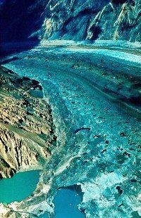
The maximum thickness of ice in the middle part reaches a kilometer, and the volume is estimated at 144 kilometers cubic - for comparison, this is about a third of the volume of Lake Erie. On the glacier, ridges of median and lateral moraines are clearly pronounced; the lower end is bombarded with moraine.
From under the tongue of the glacier flows the Seldara River, which, merging with Sauksai, forms the Muksu River. Thus, the glacier belongs to the Amu Darya basin. The lower part of the Fedchenko Glacier was discovered in 1878 by V.F. Oshanin, the middle and upper parts were discovered by the 1928 Pamir expedition.
It is named by the discoverers in honor of the Russian explorer and traveler in the Pamir, the discoverer of the Zaalaysky ridge and the peak of Lenin Alexei Pavlovich Fedchenko, who died in 1873 in the Alps. The first map of the glacier and surrounding area was compiled by the topographer I. G. Dorofeev.
Fedchenko Glacier from different sides connects with the glaciers Bivachny, Nalivkina, E. Rozmirovich, Academy of Sciences and others. Fedchenko Glacier has a width of three kilometers and a fairly gentle slope. The junction of two glaciers - Fedchenko and Bivachny - is interesting for its phenomenon - short-term high-mountain lakes with polar icebergs floating on its surface.
The glacier ends at an altitude of 2909 m. a. s. l. The glacier is surrounded by the highest peaks of the Pamirs - peaks of Communism (Somoni) 7495 m. a. s. l. of the Revolution 6940 m. a. s. l.l, Garmo 6602 m. a. s. l. and others. The general tendency of their development is a decrease in area and volume.
For example, the Fedchenko Glacier has declined by several kilometers over the past 30 years. It is known that in ancient times the Fedchenko Glacier, or as it is called in glaciological literature, the Muksui Glacier, stretched throughout the Muksu valley to the Kyzylsu River, that is, 164 kilometers.
Now its length is 77 kilometers (1958). Since 1968, glacier contraction has been observed to this day. Fedchenko Glacier, annually retreating (shortening) by an average of 14.8 meters, lost an average of 28.7 million cubic meters of ice.
It is interesting at the same time that from its upper reaches the glacier descends to the level of 3600 meters with a positive balance, "adding" annually to 4.7 million cubic meters.
And only starting from this mark and to the very bottom end (29 kilometers), its trunk with an area of only 58 square kilometers loses everything that the glacier received in the upper reaches. During the 2nd IPY, an expedition worked on the glacier, which, along with scientific research, built in the middle of the glacier at an altitude of 4200 m. a. s. l. observatory.
Observations on it continue and sow the day. Large studies were carried out on the Fedchenko Glacier by the glaciological expedition of the Academy of Sciences of the Uzbek SSR in 1957 - 1958 (Fedchenko Glacier. T. I, II. 1962). Morphologically, it is a dendritic glacier, the main stream of which begins in a large firn trough located at an altitude of about 6300 meters m. a. s. l. the foot of the peak of the Revolution on the Yazgulemsky ridge.
The wide and relatively gentle snout of the glacier stretches for 77 kilometers, taking large tributaries to the right and left. The first side moraines begin at an altitude of 4650 m. a. s. l.. A small icefall forms near the mouth of the Elena Rozmirovich glacier, after which the glacier snout becomes flat again.
After the confluence Shafts of the Kashalayak glacier appear shafts of middle moraines, which becomes more and more as the confluence of the glacier tributaries, and they stretch long, even rows down the glacier. On strips of pure ice, seraks, ice tables, and “ant heaps” are found between them.
There are many lakes on the surface of the confluence of the Bivachny glacier. The lower 6 kilometers of the glacier snout are covered with a continuous moraine cover. Glacial snout ends at an altitude of 2909 m. a. s. l. In the middle course of the glacier, a bifurcation of part of the main trunk occurs through the pass lowering to the Tanymas river basin and the formation of the Tanymassky Flap glacier 2 kilometers long.
Large tributaries of the Fedchenko Glacier are confined to the highest mountain ranges - the peaks of Communism, Garmo and the Northern Tanymas ridge. These are the glaciers Bivachny, Nalivkina, Vitkovsky and others.
Authority:
"Glaciers." L.D. Dolgushin, G.B. Osipova. Series "Nature of the world." Moscow, the publishing house "Thought". 1989.