


![]()
You are here
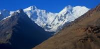
Glacier of Dzerzhinsky.

Tourist routes of mountains Pamirs.
“The expedition is over, but I still see the boundless sands of Takla-Makan and the snowy peaks of the Tien Shan, the wild expanses of Dzungaria and the stone rock of Kunlun. I see how in the loess haze the contours of large and small mountains, bordering the vast depressions of Central Asia, appear and disappear. I feel the searing heat of the hot desert wind and the piercing cold of the highlands. Deserts and mountains remained behind, but their endless blue distances, pink sunsets will forever be remembered, my friends are expedition companions”
EM. Murzaev.
Guide to Pamir mountains in Tajikistan.
The Dzerzhinsky Glacier is located in the Murghab region of the Gorno-Badakhshan Autonomous Region, on the southern slopes of the Zaalai Range in Tajikistan. The length of the glacier is 14.9 kilometers, an area of 19.0 kilometers square.
The Dzerzhinsky Glacier began to advance rapidly in 1973, and by July 1975 its end advanced into the floodplain of the Sauksai River, spreading out over an area of about 0.5 square kilometers. Only a few meters separated the front of the glacier from the opposite side of the valley, leaving a clear passage for the river.
Around the same time, the Vali glacier was moving along, with a length of 7.6 kilometers and an area of 11.9 kilometers square. In May 1976, the front of this glacier did not reach the port side of the Sauksay River valley for about 60 - 80 meters, crawling along the flat bottom of the valley in the form of a “lion's paw”.
The lower 6 kilometers of the glacial snout were split by a network of cracks, and in the upper reaches the surface decreased by 30 - 50 meters. In the spring of 1977, the front of the glacier for 300 meters abutted against the left side of the valley, blocking the channel of the Sauksai River, which flowed under the glacier (Desinov et al. 1977).
here are several more large glaciers to the west, but overall glaciation is becoming less significant. The eastern section of the Zaalaysky ridge 30 kilometers long from the Kyzylart pass to Otchaylo peak has an average height of 5500 meters above sea level, the maximum - 6610 meters above sea level - the peak of Kurumdy.
On this site, 81 glaciers with a total area of 303.6 square kilometers, 45 glaciers with an area of 240.1 square kilometers, are located on the northern slope of the ridge. There are 8 glaciers larger than 5 square kilometers. The largest are the Kyzyl su and Nura glaciers.
Authority:
"Glaciers." L.D. Dolgushin, G.B. Osipova. Series "Nature of the world." Moscow, the publishing house "Thought". 1989.
Photos
Alexander Petrov.