


![]()
You are here
Eastern Tien-Shan.
Mountains of Kyrgyzstan
“You should go to the mountains during the period of spiritual ascent”
N. Stanislavsky.
Traveling in the mountains of Kyrgyzstan.
The eastern part of the Central Tien-Shan refers to the highest mountain region of the Tien-Shan, bounded from the north by the eastern part of the Terskey-Alatau ridge, from the west by the meridian along the Sarydzhaz river valley, from the south by the state border along the Kokshaal-Too ridge and from the east by the Meridional the ridge along which the state border of Kyrgyzstan with the People's Republic of China passes.
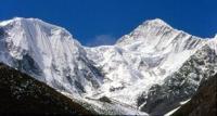
The region is characterized by powerful glaciation, the highest peaks of the Tien Shan are located here - Pobeda peak 7439 meters above sea level - the second and Khan Tengri peak 6995 meters above sea level, according to the latest data 7010 meters above sea level - the fifth highest peak in the CIS.
Administratively, the district is located in two republics - the northern part refers to Kazakhstan (Narynkol district of Almaty region), the southern part - to Kyrgyzstan (Inylchek district of Issyk-Kul region). To enter the area, registration of passes to the border zone is necessary.
The main ranges of the region are latitudinally extended. From north to south they are located in the following order: Terskey-Alatau, Adyrtor, Saryjaz, Tengri-Tag, Inylchek-Tau, Kaindy-Katta, Kokshaal-Too. The only ridge that has a meridional direction is called the Meridional ridge and is located along the eastern border of the region.
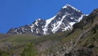
The Terskey-Alatau ridge starts from the Eleven peak in the Sarydzhaz ridge and is poorly developed within the region, has small heights and weak glaciation in the northern spurs. The slopes of the southern exposition of the ridge have no glaciers and snow cover.
The small Adyrtor ridge has the same character, small glaciers are located in its northern spurs, the slope of the southern exposure is screey in nature and completely not dissected. A powerful snow-covered barrier rises the Saryjaz ridge. Its peaks rise above 5000 m (the highest point of the ridge - Semenov peak - 5816 meters above sea level).
The ridge is characterized by powerful glaciation of the slopes of the northern exposure, the southern slopes have less powerful, but quite developed glaciation. The ridge has such a character in the eastern part, west of the peak 5063 meters above sea level, it degrades rather quickly - the heights of the peaks drop sharply, snow and glaciation sharply decrease.
To the south of the Saryjaz ridge is a short but extremely powerful Tengri-Tag ridge. It serves as a grand pedestal of the graceful pyramid of Khan-Tengri peak, which rises for a kilometer above the ridge line of the ridge.
A few more peaks in the eastern part of the ridge exceed the height of 6000 meters above sea level, to the west the ridge is somewhat lower. Further south, the snow-white slopes of the most powerful Tien Shan-Kokshaal-Too ridge with powerful northern spurs rise.
The entire eastern part of the ridge from the junction with the Meridian ridge to the Kirov peak is a grandiose snow-covered wall, the ridge line of which is at the level of 6000 meters above sea level. The rise in the eastern half of this wall with the highest elevation of 7439 meters above sea level is called Victory Peak.
To the west of Kirov peak, the ridge gradually degrades. From the Kirov peak, the Inylchek-Tau ridge branches to the north, which after a few kilometers sharply turns west and continues, gradually lowering, to the Sarydzhaz river valley.
In the eastern part, the ridge, although it cannot be compared in height with the Tengri-Tag and Kokshaal-Too ridges, has quite developed glaciation and snow. From the peak of the Red Army in the Inylchek-Tau ridge, the comparatively low Kaindy-Katta ridge branches to the west, having a developed orography of the northern slopes and completely undivided southern slopes.
In the area of Bulantor peak, the ridge branches into two parallel branches. The meridional ridge has thick glaciation and snow cover from the junction with the Kokshaaltau ridge in the south to the junction with the Saryjaz ridge in the north. Further north, it quickly degrades.
Glaciers are located in the valleys between the ranges and their spurs. The decline between the Meridian ridge in the east, the Terskey-Ala-Too ridge in the west, its spurs in the north and the Saryjaz ridge in the south is filled with the Bayankol glacier system.
Between the Terskey-Ala-Too and Adyrtor ridges, the Semenova Glacier, which is the main source of the Sarydzhaz River, flows to the west. Large glaciers of the northern slopes of the Sarydzhaz ridge are the left channels of the Mushketov glacier, flowing to the west.
The glacier has no right tributaries, since the Adyrtor ridge is the right side of the glacier bed. Between the Sarydzhaz and Tengri-Tag ranges, the large North Inylchek glacier flows to the west. Its length is more than 30 km.
The glacier is inaccessible - its valley is located between powerful ridges, and the neck of the valley is locked by the glacial lake Merzbacher. The lake is formed by the runoff of the North Inylchek glacier, spring-loaded by the ice dam of the body of the South Inylchek glacier.
Regularly once a year, usually in the first ten days of August, the lake breaks down the valley, the mechanism of the breakthrough has not yet been clarified. Between the Tengritag and Kokshaal-Too ranges, the second largest glacier of the CIS flows - South Inylchek.
Starting on the slopes of the Kokshaal-Too ridge in the easternmost part of the ridge, it flows several kilometers to the north, and then sharply turns west. Its length exceeds 60 km. Its powerful left tributaries, lying in the northern spurs of the Kokshaaltau ridge, have their own names: Zvezdochka, Wild, Proletarian tourist, Komsomolets (from east to west).
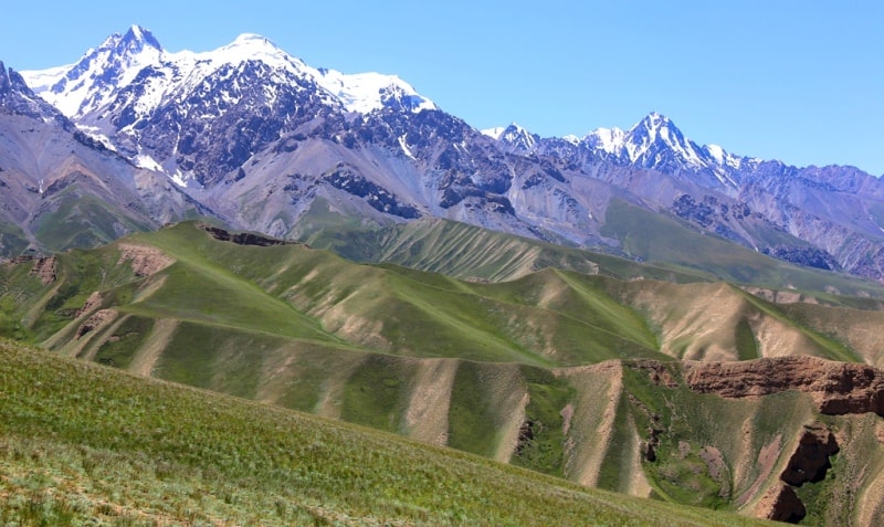
Between the Inylchektau and Kaindy-Katta ridges lies a calm Kaindy glacier about 25 km long. And finally, south of the Kaindy-Katta ridge, there is a small Kuyukap glacier. Complex snow-ice slopes, high aesthetic advantages of the highlands, valleys overgrown with Tien Shan firs and edelweiss always attract travelers to this area.


Authority:
N.A. Gvozdetsky, Yu.N. Golubchikov. Series "Nature of the World", Moscow, "Thought", 1987.
Photos:
Alexander Petrov.