


![]()
You are here
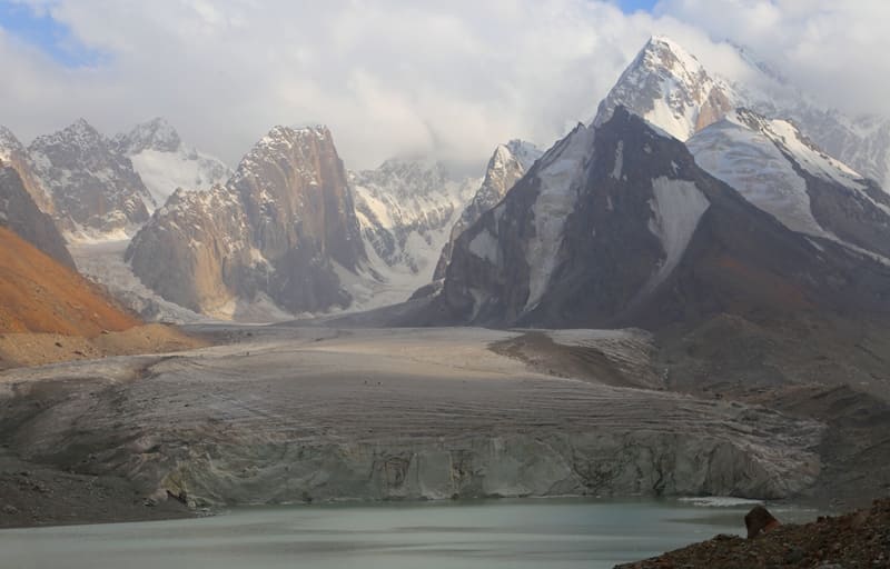
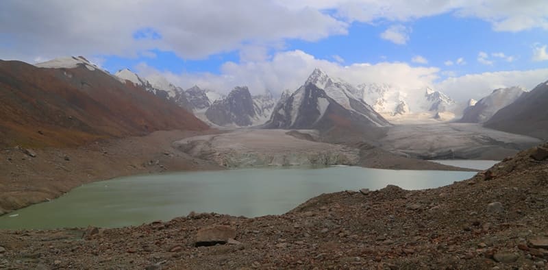
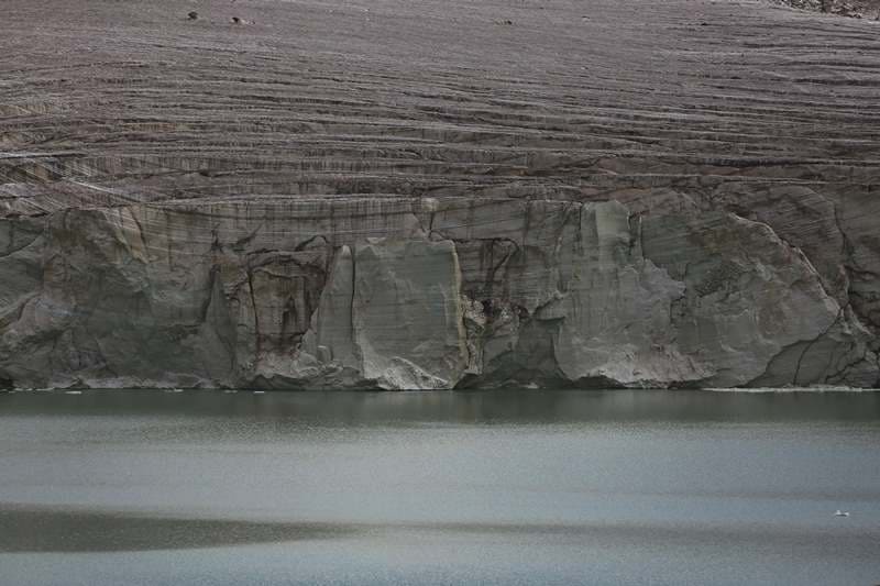
Eastern Kyzyl-Asker Glacier.

Valley glaciers on northern slope of Kakshaal-Too Range.
"In the first of these, the most impressive glaciers have accumulated in the area between an altitude of 5,895 meters and Dankov Peak. I set out to examine some of them, which were depicted as the largest in size on the military topographic map. The glacier near which I stopped on the Kyzyl-Unet River was the first from the west. Nearby, west of it, was another glacier, which could be considered a large one. Its cirque is enclosed by the massif of the 5,895-meter peak. It is not visible from the Kubergenty Pass. Not having much time, I left this glacier unexamined, beginning my work from the upper reaches of the Kyzyl-Unet."
N.N. Palgov. "Along Central Tien-Shan." 1930.
Trip from Naryn to Eastern Aksai River Valley.
Kyzyl-Asker East Valley Glacier No. 80 is located within Kyzyl-Asker mountain range, on northern slope of western Kakshaal-Too Range in upper reaches of East Kyzyl-Asker River in Atbashi District of Naryn Region.
Kyzyl-Asker East Glacier No. 80 extends for 7.4 kilometers, covers an area of 9.06 square kilometers, has a perimeter of 35.65 kilometers, and reaches a maximum width of 1.7 kilometers in the central portion.
The upper boundary of the glacier ranges from 5,842 meters above sea level (Kyzyl-Asker Peak), 5,085 meters above sea level (Kyzyl-Asker East Peak), 5,085 meters above sea level (Kyzyl-Asker East Peak), and 5,300 meters above sea level (Neizvestny Soldat Peak).
The glacier's tongue is located at an altitude of 3,850 meters above sea level. On the eastern side, the Kyzyl-Asker East Glacier is separated from the Komarova West (Kyzylunet) Glacier by an 11-kilometer-long latitudinal ridge. On the western side, a 9-kilometer-long latitudinal ridge separates the Kyzyl-Asker West Glacier.
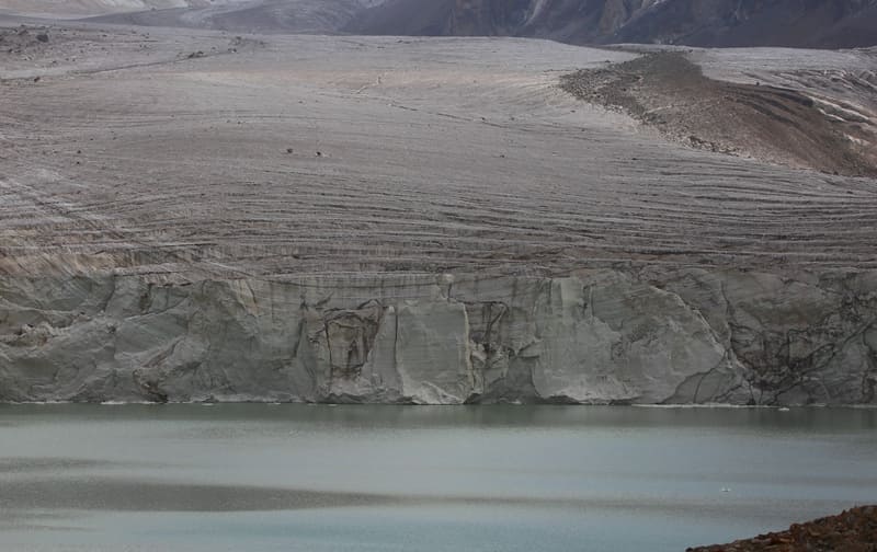
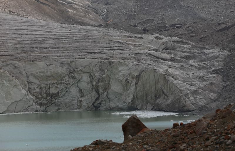
From the glacier's tongue, amidst rugged peaks and silent snowy expanses, the East Kyzyl-Asker River originates, flowing from a lake of the same name fed by the glacier's meltwater. For 5 kilometers, the glacier lies in a wide valley; the rest of its upper reaches lies in a narrow mountain gorge, framed by sheer granite and crystalline schist walls.
To the south, it is backed by the powerful spurs of the northern slopes of the Kakshaal-Too Range. On the northern side, the glacier gradually descends to a glacial lake, which begins immediately behind the glacier tongue and is the source of the Eastern Kyzyl-Asker River.
The ice surface is dissected by crevasses and, in the lower sections, is covered with moraine deposits, giving the glacier its characteristic gray hue. The moraine ridges indicate a gradual retreat of the glacier over recent decades, consistent with the general trend of degradation of Tien-Shan glaciers.
Origin and Geological Context of Eastern Kyzyl-Asker Glacier
The Eastern Kyzyl-Asker Glacier formed in the late Holocene, as a result of the accumulation of snow masses in a closed cirque on the northern slope of the Kakshaal-Too Range. Ancient crystalline rocks of Paleozoic age—gneisses, granites, and metamorphic schists - underlie the glacier's base.
The snow and ice are fed by winter snowfalls and snow drifts from neighboring peaks, where solid precipitation amounts reach up to 1000 mm per year. During the warm season, meltwater streams form on the glacier's surface, creating temporary glacial lakes and subglacial streams that feed the glacial lake.
The waters of these rivers and streams are crystal clear and possess typical mountain transparency and mineral composition.
Research and Observations of Kyzyl-Asker Eastern Glacier.
The first mentions of the glaciers of the Kyzyl-Asker massif date back to the 1930s, when Soviet topographic and glaciological expeditions explored the Kakshaal-Too glaciers. In 1908, V.V. Sapozhnikov visited the area and drew attention to the feasibility of diverting part of the Aksai River's waters into the Naryn basin through the ridge on which the Kubergenty Pass is located.
He cited interesting figures confirming the feasibility of this undertaking. While one cannot disagree with these conclusions, it is also clear that the cost of the work would be very high. First and foremost, two dams would need to be built: one to hold back the waters of the Kyzyl-Unet with other small tributaries of the Aksai River, and another for the Oto-Tash River (the Kotur River, A.P.), also with corresponding tributaries; then direct the waters of the resulting collection basin through the Kubyrgenty Pass, where, according to V.V. Sapozhnikov's rough estimates, it will be necessary to dig a canal or tunnel 3 - 4 kilometers through a 117-meter-thick layer of rock.
It is possible that this rock at depth will be dense, and not a continuation of the moraine deposits lying above. Be that as it may, the idea is bold, and it would be worthwhile to clarify its practical significance through detailed research. In 1930, N.N. Palgov began his journey from the city of Naryn, ascending the upper reaches of the Naryn River and along the Karakol River valley, passing the Kubyurgenty Pass and crossing the high-mountain watershed plateau of Kagaliachap. A week later, he began exploring the glaciers on the northern slope of the western part of the Kakshaal-Too Range.
He surveyed five glaciers, which he named: Komarov, Mushketov, Nalivkin, Malitsky, and Fersman. Subsequently, in the 1970s and 1980s, the glacier was included in the list of monitored objects of the Glaciological Service of Kyrgyzstan under number 80.
Periodic measurements revealed a gradual reduction in the glacier's area - an average of 5 - 7 meters in length annually, consistent with the current melting rate of glaciers in the Central Tien-Shan.
Significance and natural environment of Kyzyl-Asker East Glacier.
Kyzyl-Asker East Glacier No. 80 is an important element of the region's high-altitude water balance. It serves as a natural moisture reservoir, feeding rivers during the dry season and providing stable runoff for the lower valleys of the At-Bashi district. Typical alpine flora and fauna - mosses, lichens, and short grasses adapted to the harsh high-altitude conditions - are found around the glacier.
The slopes of the surrounding peaks are covered with sparse alpine vegetation, including rare blue milkvetch, mountain poppy, and rare species of wormwood. The most common flora representatives here are: Alpine bluegrass (Poa alpina L.), Sheep fescue (Fessuca ovina), three-style chickweed (Cerastium trigynum), ice grass, ice buttercup, Kamchatka buttercup, ice grass (Oxygraphis glaciali), Smelowskia calycina (C. A. Mey), alpine streusel (Draba algida), whiskered saxifrage (Saxifraga flagellaris Willd.), frosty radiola (Sedum algidum Led b.), spicate oxytropis (Oxytropis sp.), hairy rockweed (Androsace villosa L.), large rockweed (Androsace maxima L.), edelweiss richteria (Richteria leontopodium C. W.), white-leaved Saussurea, white-leaved bittersweet, silver-leaved bittersweet, silver-leaved Saussurea, and silver-leaved Saussurea (Saussurea leucophylla Schrenk).
For travelers and explorers visiting glaciers of Kyzyl-Asker massif.
Kyzyl-Asker East Valley Glacier No. 80 is a difficult-to-reach place and therefore rarely visited. The route to it lies through the upper reaches of the East Aksai River valley and further along the East Kyzyl-Asker River valley. Access to the glacier requires good physical fitness and mountaineering equipment.
At altitudes above 4,000 meters, the weather is changeable, with frequent strong winds, snow drifts, and low temperatures even in July. However, it is here that travelers experience the true grandeur of the mountains: a silence in which only the crackling of ice and the rustling of the wind can be heard, the fresh scent of eternal snow, and the sensation of touching the ancient natural forces that have shaped the Inner Tien-Shan for millions of years.
Legend of Kyzyl-Asker Warriors
Since ancient times, local shepherds and hunters have told stories of a detachment of brave warriors once stationed on these peaks, guarding the path between the valleys. They were called Kyzyl-Asker—"Red Warriors." Legend has it that a great snowstorm, unprecedented in its strength and cold, once swept across the country.
The warriors remained at their post and fought the elements, protecting the pass and the people below. In the morning, the snowstorm subsided, but the people who climbed to the pass found not a single living guard. Only blindingly white snow covered the peaks, and above them shone the reddish glow of the rising sun.
Since then, the mountains have been known as Kyzyl-Asker - the Mountains of the Red Warriors - and the glacier on their northern slope - their eternal resting place. It is said that on clear evenings, when the sunset's rays paint the ice pink-gold, one can glimpse the silhouettes of the ancient guardians - as if the mountains still remember them.
Geographical coordinates of Kyzyl-Asker Glacier East No. 80: N41°03'48 E77°20'53
Authority and photos by:
Alexander Petrov.