


![]()
You are here
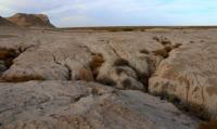
Eastern Kum-kala (Kum-kala II).
Excursion Kazakhstan.
“Our entire history is a product of the nature of that vast land that we have inherited. It was she who scattered us in all directions and scattered us in space from the first days of our existence"
Chaadaev P. Ya.
Cultural walks in Kyzylorda.
The Eastern Kum-kala settlement (Kum-kala II) is located in the Zhalagash district of the Kyzylorda region, 35.5 kilometers southeast of the Akkyr village and 45.9 kilometers southwest of the Zhanadarya village. Eastern Kum-Kala (Kum-Kala II) is located 4.5 kilometers east of the Kum-Kala fortress on the banks of the Zhanadarya.
Eastern Kum-kala is a large, but unfortified feudal estate with an adjoining village. It consists of a large residential complex, which is a rectangle 200 x 155 meters in plan, with the ruins of a residential building, in which rooms and corridors are preserved in a row; ayvans adjoined the house from the north, and a courtyard from the south.
The construction of the walls surrounding the courtyard, as well as the walls of the house itself, was of poor quality: these are interleaved layers of adobe bricks of non-standard sizes and clay. To the north of the residential complex of the estate, there was a large plot (area 160 x 140 meters) of the outer courtyard or garden, enclosed by a clay wall of the duval type without any traces of fortification; the gate was in the northern wall.
Near the eastern wall in the garden there was a building (with an area of about 35 x 22 meters), from which only an oblong hillock with a height of 1.5 meters has survived. This was probably a house for receiving guests, possibly a kaptar-khan; right in front of the house, in the center of the garden, there was a small square pond - hauz.
The ceramics from the Eastern Kum-kala have common features with the ceramics of the Uygarak settlement. There are a lot of glazed dishes, dating by analogy with the Khorezm forms of the XII-XIV centuries, among the unglazed ceramics there are stucco products, various cauldrons, ornamented lids, hive-shaped hearths, lamps.
The ruins of Martyk-kala are located 1.6 kilometers north-east of Eastern Kum-Kala.
Geographic coordinates of the Eastern Kum-Kala settlement (Kum-Kala II): N44 ° 28'35.76 "E64 ° 13'31.94"
Authority:
A.A. Tazhekeyev, R.T. Darmenov. "Bulletin of KazNU". 2012. Almaty
https://articlekz.com/article/7260
Photos by
Alexandr Petrov.